MyTopo
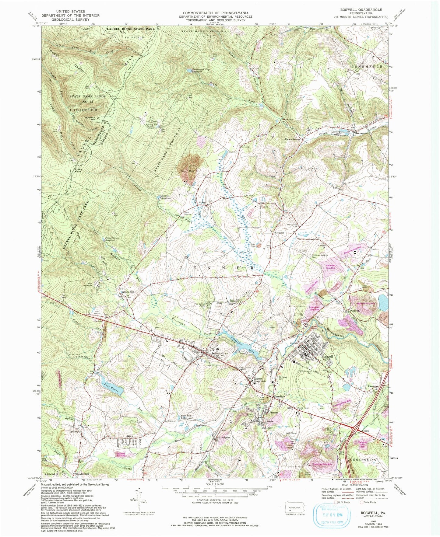
Classic USGS Boswell Pennsylvania 7.5'x7.5' Topo Map
Couldn't load pickup availability
Historical USGS topographic quad map of Boswell in the state of Pennsylvania. Typical map scale is 1:24,000, but may vary for certain years, if available. Print size: 24" x 27"
This quadrangle is in the following counties: Somerset, Westmoreland.
The map contains contour lines, roads, rivers, towns, and lakes. Printed on high-quality waterproof paper with UV fade-resistant inks, and shipped rolled.
Contains the following named places: Ankeny, Beam Church, Beaverdam Creek, Beaverdam Run, Beverly Lake, Boswell, Boswell Reservoir, Camp Sequanota, Card Machine Run, Coal Run, Conemaugh Township Reservoir, Ferrellton, Flat Run, Forwardstown, Gilbert Hollow, Glessner, Lake Gloria, Gray, Gum Run, Hoffman Run, Irwin Hill, Jenners, Jenners Crossroads, Jennerstown, Jennerstown Reservoir, Laurel Hill Tabernacle, Meadowdale, Middle Hill, Mount Carmel Cemetery, Mount Zion Church, Mystery Hill, Calvary Cemetery, Pickings Run, Pikes Peak, Pilltown, Pine Hill, Pine Run, Pine Springs Camp, Randolph, Roaring Run, Roaring Run Camp, Rose Bud Lake, Saint James Church, Saint Josephs Church, Saint Mary's Polish National Cemetery, Saint Marys Church, Saint Stanislaus Cemetery, Saints Peter and Paul Cemetery, Spruce Run, Stoughton Lake, Sugar Camp Hill, Thomasdale, Beam Run, Bearpen Hollow, Laurel Hill, North Branch Quemahoning Creek, North Branch South Fork Bens Creek, State Game Lands Number 42, Lohr's Landing Airport (historical), Gallo Dam, Jennerstown Dam, Conemaugh Township Impounding Dam, Coal Junction, Klines Mill, Beisecker School (historical), Cooper School, Maurer School, Shunk, Thomasdale School, Saylor School, Hare School, Muller School, Oakbrook Golf Course, Morgans Mills, Conner Post Office (historical), Borough of Boswell, Borough of Jennerstown, Township of Jenner, Boswell Volunteer Fire Department - Station 605, Jennerstown Volunteer Fire Department - Station 606, Boswell Quarry, Gray Post Office, Jennerstown Post Office, Boswell Post Office, Boswell Borough Police Department, Jennerstown Borough Police Department, Ankeny, Beam Church, Beaverdam Creek, Beaverdam Run, Beverly Lake, Boswell, Boswell Reservoir, Camp Sequanota, Card Machine Run, Coal Run, Conemaugh Township Reservoir, Ferrellton, Flat Run, Forwardstown, Gilbert Hollow, Glessner, Lake Gloria, Gray, Gum Run, Hoffman Run, Irwin Hill, Jenners, Jenners Crossroads, Jennerstown, Jennerstown Reservoir, Laurel Hill Tabernacle, Meadowdale, Middle Hill, Mount Carmel Cemetery, Mount Zion Church, Mystery Hill, Calvary Cemetery, Pickings Run, Pikes Peak, Pilltown, Pine Hill, Pine Run, Pine Springs Camp, Randolph, Roaring Run, Roaring Run Camp, Rose Bud Lake, Saint James Church, Saint Josephs Church, Saint Mary's Polish National Cemetery, Saint Marys Church, Saint Stanislaus Cemetery, Saints Peter and Paul Cemetery, Spruce Run, Stoughton Lake, Sugar Camp Hill, Thomasdale, Beam Run, Bearpen Hollow, Laurel Hill, North Branch Quemahoning Creek, North Branch South Fork Bens Creek, State Game Lands Number 42, Lohr's Landing Airport (historical), Gallo Dam, Jennerstown Dam, Conemaugh Township Impounding Dam, Coal Junction, Klines Mill, Beisecker School (historical), Cooper School, Maurer School, Shunk, Thomasdale School, Saylor School, Hare School, Muller School, Oakbrook Golf Course, Morgans Mills, Conner Post Office (historical), Borough of Boswell, Borough of Jennerstown, Township of Jenner, Boswell Volunteer Fire Department - Station 605, Jennerstown Volunteer Fire Department - Station 606, Boswell Quarry, Gray Post Office, Jennerstown Post Office, Boswell Post Office, Boswell Borough Police Department, Jennerstown Borough Police Department