MyTopo
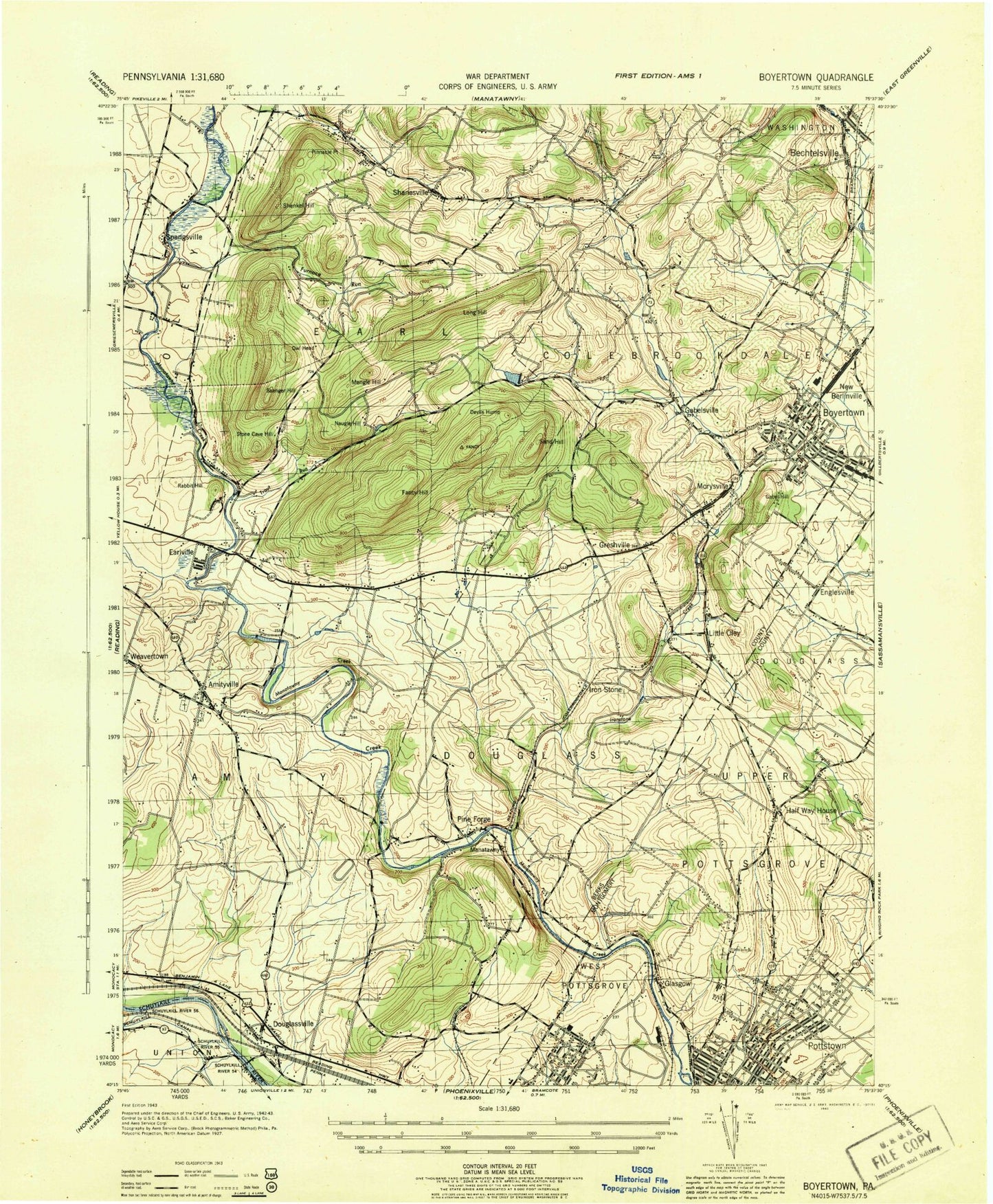
Classic USGS Boyertown Pennsylvania 7.5'x7.5' Topo Map
Couldn't load pickup availability
Historical USGS topographic quad map of Boyertown in the state of Pennsylvania. Typical map scale is 1:24,000, but may vary for certain years, if available. Print size: 24" x 27"
This quadrangle is in the following counties: Berks, Montgomery.
The map contains contour lines, roads, rivers, towns, and lakes. Printed on high-quality waterproof paper with UV fade-resistant inks, and shipped rolled.
Contains the following named places: Bechtelsville, Boyertown, Boyertown Reservoir, Brookside Country Club, Camp Grove, Camp Manatawny, Camp Taggart, Devils Hump, Douglassville, Earlville, Englesville, Fairview Cemetery, Fancy Hill, Furnace Hill, Furnace Run, Gabel Hill, Half Way House, Hanawas Sachem Cemetery, Highland Memorial Park, Holy Trinity Cemetery, Ironstone Creek, Mengle Hill, Mission Church, Morysville, Naugle Hill, New Berlinville, Oley Valley, Owl Head, Pine Forge Institute, Pottstown Community Camp, Rabbit Hill, Saenger Hill, Saint Aloysius School, Saint Gabriel School, Salem Church, Sand Hill, Shanesville Chapel, Stone Cave Hill, Stowe, Trout Run, Union Cemetery, Union Cemetery, Union Mission Camp, Washington Hill, West End School, Worman, Long Hill, Pinnacle Point, Shenkel Hill, Pottstown Municipal Airport, Dimascio Field, Morysville Body Works Airport (historical), Trout Run Reservoir, Trout Run Dam, Boyertown Reservoir Dam, Little Oley, Colebrookdale Station (historical), Manatawny Station (historical), WPAZ-AM (Pottstown), Hanover Court, West Pottsgrove, Amityville, Cedar Grove, Colebrookdale, Gabelsville, Glasgow, Greshville, Ironstone, Pine Forge, Shanesville, Spangsville, Upper Glasgow, Woodchoppertown, Pottstown Airport Industrial Park, Congregation Mercy and Truth Cemetery, Saint Johns Greek Catholic Cemetery, Hillside Gospel Chapel, North End Shopping Center, Pottstown Cemetery - West, Pottsgrove Mansion, Leader Nursing Rehabilation Center, West Farm Dam, Spotts Mill Dam, Weidner Dam, Pottstown Senior High School, Pottstown Junior High School, West Pottstown Elementary School, Franklin Elementary School, Lincoln Elementary School, Borough of Bechtelsville, Borough of Boyertown, Borough of Pottstown, Township of Amity, Township of Colebrookdale, Township of Douglass, Township of Earl, Township of Upper Pottsgrove, Amity Gardens, Halfway House, Amity Gardens Census Designated Place, Halfway House Census Designated Place, Stowe Census Designated Place, Franklin Mini-park, Boyertown Area Fire and Rescue Station 95 - 1, Fritz Cemetery, Full Gospel Church of the Living Waters, Gabelsville Athletic Association Field, Gabelsville Athletic Association Headquarters, Gabelsville Church of Christ, Garrett Hall, General Douglass House, Alpha Omega Christian Academy, Amity Fiire Department Station 49, Amity Gardens Apartments, Amity Industrial Park, Amity Intermediate School, Amity Manor, Amity Primary Center, Amity Township Municipal Building, Amity Township Sewage Treatment Plant, Amityville Community Park, Ark Bible Chapel, Bahr's Mill, Bear Stadium, Bechtelsville Borough Hall, Bechtelsville Recreation Park, Boone Area Library, Boyertown Area High School, Boyertown Area Multi-Service Office, Boyertown Borough Hall, Boyertown Community Center, Boyertown Community Park, Boyertown Elementary School, Boyertown Industrial Park, Boyertown Junior High West, Boyertown Community Ambulance Service, Boyertown Medical Services Center, Boyertown Mennonite Church, Boyertown Museum of Historic Vehicles, Boyertown Museum of Historic Vehicles Office, Boyertown Pool, Boyertown Post Office, Boyertown Rod and Gun Club, Boyertown Water Treatment Plant, Boyertown Area Historical Society, Brookview, Catacombs Church, Charles B. Yerger American Legion Post 471, Christ Lutheran Church, Cider Mill Open Space, Cider Mill Run, Colebrookdale Chapel, Colebrookdale District Police Department, Colebrookdale Elementary School, Colebrookdale Township Office, Colebrookdale Township Public Works, Colebrookdale Village Shopping Center, Covered Bridge Keepers House, Daniel Boone Middle School, Douglass Township Building, Douglassville Post Office, Douglassville Shopping Center, Earl Elementary School, Earl Municipal Park, Earl Township Building, Earl Township Volunteer Fire Company 1 Station 19, Lake Drive Park and Recreation Area, Laurel Mountain Ministries Chapel, Lazy K Campground, Boyertown Area Fire and Rescue Station 95, Liberty Fire Company Hall, Little Oley Post Office (historical), Locust Grove Park, Old Airport Road Open Space, Old Dutchman Trail, Oley Cemetery, Orchard Hills, Pheasantland Roller Dome, Pine Forge Academy Pool, Pine Forge Commissary, Pine Forge Elementary School, Pine Forge Sportsmen's Club, Retreat Center, Rolling Hills Landfill, Salvation Army, Salvation Army, Second Baptist Church Cemetery, Rosecliff, Saint Columbkill's Roman Catholic Church, Saint Gabriel's Episcopal Church, Saint Johns Evangelical Lutheran Church, Saint Michael's Ukrainian Catholic Cemetery, Saint Pauls Section 1 Cemetery, Saint Paul's Lutheran Church, Saint Pauls United Church of Christ, Masonic Lodge Number 741, Mouns Jones House, Mountain View Chapel, Municipal Park, Myron S. Wheeler Park, Glen Dale Swimming Association, Glen Dale Swimming Association Pool, Good Shepherd United Church of Christ, Goose Run Park, Grace Independent Baptist Church, Greenbriar, Greenbriar Open Space, Griesemers Mill, Griesemers Mill Covered Bridge, High Meadows, I O O F Hall, Indian Springs Village, Irey Mansion, Ironstone Park, Ironstone Station (historical), J. K. Boyer Boyertown Community Library, Jehovah's Witnesses Kingdom Hall, Boyertown Area Fire and Rescue Station 95 - 2, Thomas Rutter Mansion, Trinity Evangelical Lutheran Church, Wagner Hall, Walnut Woods, Weidner Mill, White Horse Tavern, Woods Edge, Woods Edge Open Space, YMCA, Douglassville Census Designated Place, New Berlinville Census Designated Place, Pottstown Fire Department - North End Fire Company - Station 69 - D, Upper Pottsgrove Township Fire Company 1 Station 79, West End Fire Company 1 - Station 57, Eastern Berks Fire Department 97 - 3, Bechtelsville Post Office, New Berlinville Post Office, Boyertown Union Church Cemetery