MyTopo
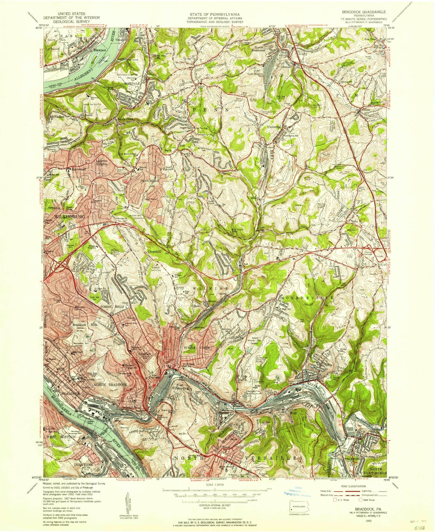
Classic USGS Braddock Pennsylvania 7.5'x7.5' Topo Map
Couldn't load pickup availability
Historical USGS topographic quad map of Braddock in the state of Pennsylvania. Typical map scale is 1:24,000, but may vary for certain years, if available. Print size: 24" x 27"
This quadrangle is in the following counties: Allegheny, Westmoreland.
The map contains contour lines, roads, rivers, towns, and lakes. Printed on high-quality waterproof paper with UV fade-resistant inks, and shipped rolled.
Contains the following named places: William Penn Gardens of Remembrance, Advent Church, Atlantic School, Bell Avenue School, Ben Franklin School, Bessemer, Bethel Church, Beulah Church, Black Ridge, Blawnox, Braddock, Braddock Cemetery, Braddock Hills, Brush Creek, Cavettsville, Center, Chalfant, Chalfant Run, Christ Church, Christian School, Churchill, Churchill Cemetery, Churchill Valley, Convenant Church, Copeland School, Crescent Hills, Crossroads Cemetery, Davidson School, Dixon Avenue School, East McKeesport, East Pittsburgh, Eastmont, Eastvue, Electric Heights Church, Electric Heights School, Fairview Cemetery, Forest Hills, Forest Hills Park, Fox Chapel School, Franklin School, Garden City, Gascola, Gateway High School, Gilmore School, Grace Church, Graham Field, Grandview Cemetery, Gray Elementary School (historical), Hall, Hanatown School, Harding School, Hartman Junior High School, Hawthorne School, Hebron Cemetery, Hebron School (historical), Holy Trinity Priory, Hope Church, Howard Street School, Jordan School, Keats School, Laketon Heights, Leak Run, Leak Run, Linhart, Little Plum Creek, Marian School, Mellon School, Monongahela Cemetery, Monroe Heights, Mount Hope Cemetery, Mount Hope Church, Nadine, Newtown, Ninemile Island, North Bessemer, North Bessemer Yards, North Braddock, Oak Hill, Park Terrace School, Patton School, Penn Hills Church, Penn Ridge, Pitcairn, Port Perry Bridge, Quigley Creek, Rodi, Rosedale, Saint Bartholomews Church, Saint Bernadette Church, Saint Brendans Church, Saint James Church, New Saint Josephs Cemetery, Saint Martins Church, Saint Maurice School, Saint Nicholas Cemetery, Saint Robert Bellarmine School, Sandy Creek, Sandy Creek, Sawmill Run, Sco High School, Semple School, Shadow Shuttle, Shady Park School, Shannon Heights, Sycamore Island, The Good Shepherd Church, Thompson Run, Thompson Run, Trafford, Turtle Creek, Unity, Universal, Wall, Washington School (historical), West Wilmerding, Westinghouse Bridge, Wilkins Township School, Wilmerding, Woodlawn Cemetery, Woodside Elementary School (historical), Zion Church, New Texas, Turtle Creek, Westinghouse E Pittsburgh Airport (historical), Howard Johnsons Motor Lodge Airport (historical), Pittsburgh-Monroeville Airport, O'Brien Airport (historical), Monongahela River Pool Two, Braddock Locks and Dam, William D Boyce Regional Park, Clifford M Dible Elementary, Hebron Elementary, Stewart, Forest Hills Middle School, Turtle Creek High School, Regency Park, Eastwood, WHYW-FM (Braddock), WHYW-AM (Braddock), WRUA-AM (Monroeville), WPCB-TV (Greensburg), Monroeville, Bessemer Junction, Kennywood Park, Port Perry, Unity Junction, Bellwood Preschool and Kindergarten, Center Elementary School, East Mont Elementary School, Electric Plant Elementary School, Evergreen Elementary School, Forbes Elementary School, Homeville Elementary School, Johnston Elementary School, Gateway Junior High School, Northern Pike Elementary School, John Morrow Elementary School, Gateway Upper Elementary School, West Mifflin Area High School, Roberts Vocational Center, Seneca Junior High School (historical), Turner Elementary School, Wilkins Middle School, Leohmans Plaza, Monroeville Mall, Monroe Plaza, Miracle Mile Shopping Center, Churchill High School, Sanford B Shaffer Elementary School, Shenandoah Elementary School, Washington Elementary School, Penn Hills Senior High School, John H Linton Junior High School, Plum Senior High School, Regency Park Elementary School, East Hill Elementary School, Westinghouse Elementary School, Pitcairn Building Plus Three Elementary School, Unity Junction, Hall Station, Taylor, Pitcarin Station, Fort Perry Station, Newton Station, Oak Hill Station, Hindu Temple, Tower Station, Duquesne Wharf Station, Bessemer Station, Monongahela Junction Station, Braddocks Field (historical), Alcoma Golf Course, Churchill Valley Country Club, Edgewood Country Club, Restland Memorial Park, Temple Sinai Memorial Park, Westmoreland Country Club, Peter Mans Corner, Duquesne, Trafford Station, Trafford Elementary School (historical), Trafford High School (historical), B Y Recreational Park Lake, South Trafford, The Terrace, Penn Trafford Middle School, Duffs Run, Borough of Blawnox, Borough of Braddock, Borough of Braddock Hills, Borough of Chalfant, Borough of Churchill, Borough of East McKeesport, Borough of East Pittsburgh, Borough of Forest Hills, Borough of North Braddock, Borough of Pitcairn, Borough of Turtle Creek, Borough of Wall, Borough of Wilkinsburg, Borough of Wilmerding, Township of North Versailles, Township of Penn Hills, Township of Wilkins, Borough of Trafford, Municipality of Monroeville, North Versailles, Children's Hospital of Pittsburgh East, North Versailles Census Designated Place, O'Hara Township Census Designated Place, Penn Hills Census Designated Place, Wilkins Township Census Designated Place, American Diabetes Association Building, Auberle Girls Group Home, Banks Childrens Learning Center, Ben Fairless Intermediate School Library