MyTopo
Classic USGS Brandywine Maryland 7.5'x7.5' Topo Map
Couldn't load pickup availability
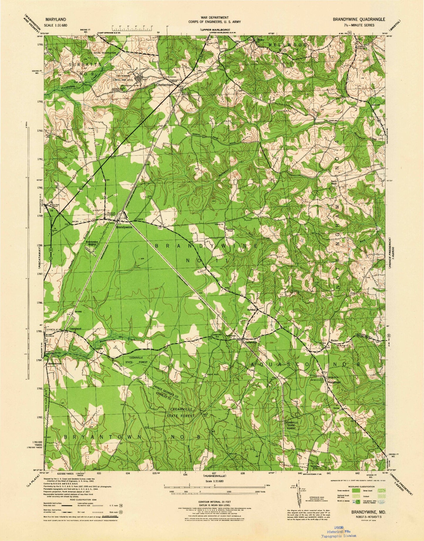
Historical USGS topographic quad map of Brandywine in the state of Maryland. Typical map scale is 1:24,000, but may vary for certain years, if available. Print size: 24" x 27"
This quadrangle is in the following counties: Charles, Prince George's.
The map contains contour lines, roads, rivers, towns, and lakes. Printed on high-quality waterproof paper with UV fade-resistant inks, and shipped rolled.
Contains the following named places: Hidden Spring Trail, Left Trail, Panhandle Trail, South Trail, Sunset Trail, West Trail, Wolf Den Trail, Ashbox, Baden, Bee Oak Trail, Boys Village of Maryland, Brandywine, Brandywine Church, Brandywine Heights, Cedarville, Cedarville School, Cedarville State Forest, Cheltenham, County Line Trail, Cross Road Trail, Duley, Gibbons Church, Gwynn Park High School, Horsehead, Immanuel Church, Loop Trail, Magnolia Trail, Mistletoe Trail, North Keys, Orme, Orme School, Saint Michael Church, Saint Pauls Church, Saint Simons Church, Saint Thomas Church, T B, Townshend, NOS Magnetic Observatory, Curtis Field (historical), Cedarville Natural Resources Management Area, Cedarville Pond, Country Club South, Mattawoman Estates, Pinefield, Pinefield Community Park, Trinity Baptist Church, Western Regional Park, Baden Branch Prince George's County Memorial Library, Baden Elementary School, Brandywine Area Recreation Area, Brandywine Bible Church, Brandwine Elementary School, Brandywine Forest, Brandywine Post Office, Brandywine School (historical), Cedarville Assembly of God Church, Cedarville Mobile Home Park, Chapel of the Incarnation, Cheltenham Acres, Cheltenham Acres Recreation Area, Cheltenham United Methodist Church Cemetery, Cheltenham Post Office, Cheltenham United Methodist Church, Maryland Veterans Cemetery, Church of the Atonement (historical), Church of the Atonement Cemetery, Early Manor, Edgemeade School, Cedarville Assembly of God Church Cemetery, Grace Methodist Episcopal Church (historical), Gwynn Park, Gwynn Park Middle School, Heatherwick, Holt Manor, Immanuel United Methodist Church Cemetery, Land Tree, Marlton South, North Keys Estates, Saint Pauls Episcopal Cemetery, Saint Simons Church Cemetery, Saint Simons School (historical), Saint Thomas Episcopal Church Cemetery, Sunrise Hills, T B School (historical), Talbert (historical), The Village, West End Farms, Windsor Manor, Mattaponi Elementary School, District 11 Brandywine, Croom High School, Baden Branch Library, Brandywine Volunteer Fire Department Station 840, Baden Volunteer Fire Department Station 836, Concordia Lutheran Preschool, William Schmidt Environmental Center School, Concordia Lutheran School and Child Care Center, Cedarville Census Designated Place, Croom Census Designated Place, Good Fortune Farm, Hidden Spring Trail, Left Trail, Panhandle Trail, South Trail, Sunset Trail, West Trail, Wolf Den Trail, Ashbox, Baden, Bee Oak Trail, Boys Village of Maryland, Brandywine, Brandywine Church, Brandywine Heights, Cedarville, Cedarville School, Cedarville State Forest, Cheltenham, County Line Trail, Cross Road Trail, Duley, Gibbons Church, Gwynn Park High School, Horsehead, Immanuel Church, Loop Trail, Magnolia Trail, Mistletoe Trail, North Keys, Orme, Orme School, Saint Michael Church, Saint Pauls Church, Saint Simons Church, Saint Thomas Church, T B, Townshend, NOS Magnetic Observatory, Curtis Field (historical), Cedarville Natural Resources Management Area, Cedarville Pond, Country Club South, Mattawoman Estates, Pinefield, Pinefield Community Park, Trinity Baptist Church, Western Regional Park, Baden Branch Prince George's County Memorial Library, Baden Elementary School, Brandywine Area Recreation Area, Brandywine Bible Church, Brandwine Elementary School, Brandywine Forest, Brandywine Post Office, Brandywine School (historical), Cedarville Assembly of God Church, Cedarville Mobile Home Park, Chapel of the Incarnation, Cheltenham Acres, Cheltenham Acres Recreation Area, Cheltenham United Methodist Church Cemetery, Cheltenham Post Office, Cheltenham United Methodist Church, Maryland Veterans Cemetery, Church of the Atonement (historical), Church of the Atonement Cemetery, Early Manor, Edgemeade School, Cedarville Assembly of God Church Cemetery, Grace Methodist Episcopal Church (historical), Gwynn Park, Gwynn Park Middle School, Heatherwick, Holt Manor, Immanuel United Methodist Church Cemetery, Land Tree, Marlton South, North Keys Estates, Saint Pauls Episcopal Cemetery, Saint Simons Church Cemetery, Saint Simons School (historical), Saint Thomas Episcopal Church Cemetery, Sunrise Hills, T B School (historical), Talbert (historical), The Village, West End Farms, Windsor Manor, Mattaponi Elementary School, District 11 Brandywine, Croom High School, Baden Branch Library, Brandywine Volunteer Fire Department Station 840, Baden Volunteer Fire Department Station 836, Concordia Lutheran Preschool, William Schmidt Environmental Center School, Concordia Lutheran School and Child Care Center, Cedarville Census Designated Place, Croom Census Designated Place, Good Fortune Farm