
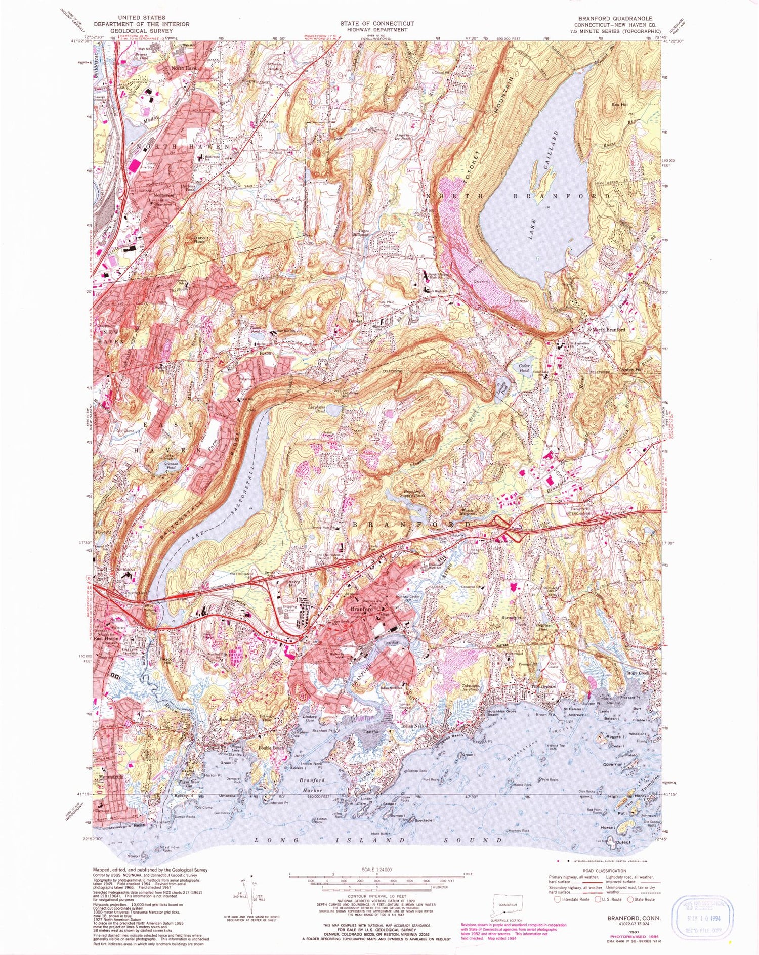
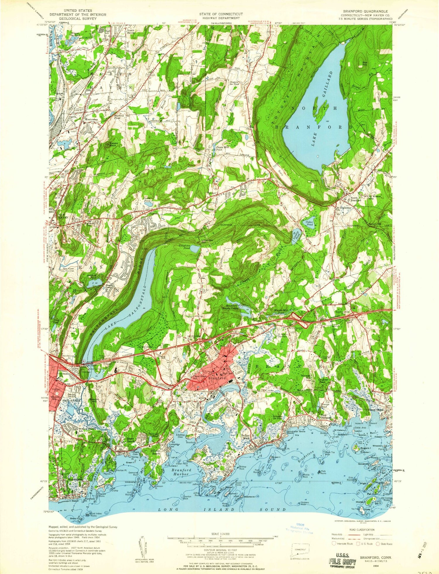
MyTopo
Classic USGS Branford Connecticut 7.5'x7.5' Topo Map
Couldn't load pickup availability
Historical USGS topographic quad map of Branford in the state of Connecticut. Typical map scale is 1:24,000, but may vary for certain years, if available. Print size: 24" x 27"
This quadrangle is in the following counties: -.
The map contains contour lines, roads, rivers, towns, and lakes. Printed on high-quality waterproof paper with UV fade-resistant inks, and shipped rolled.
Contains the following named places: All Saints Cemetery, Andrews Island, Augurs Ice Pond, Bare Plain Cemetery, Beacon Hill, Belden Island, Bishop Rock, Blackstone Rocks, Branford, Branford Center Cemetery, Branford Harbor, Branford High School, Branford Hills School, Branford Point, Branford Supply Ponds, Brown Point, Bruces Ice Pond, Mary T Murphy School, Burr Island, Burrs Brook, Camp Hubinger, Canoe Brook School, Cedar Island, Cedar Lake School, Cedar Pond, Cherry Hill, Clam Island, Crooked Brook, Damascus Cemetery, Mary R Tisko School, Darrow Rocks, Deer Run School, Democrat Rock, Dick Rocks, Double Beach, East Haven, East Indies Rocks, East Lawn Cemetery, Farm River, Farm River Gut, Dominic H Ferrara School, Fivemile Brook, Flying Point, Foot Rocks, Foxon, Foxon Pond, Frisbie Island, Lake Gaillard, Gillis School, Governor Island, Graniss Pond, Green Island, Green Island, Greenlawn Cemetery, Griffins Pond, Gull Rocks, Harbor Street School, Harrison Avenue School, Jerome Harrison School, Hartens Pond, Haycock Point, Hays School, High Island, Highland School, Hookers Rock, Horse Island, Horton Point, Hotchkiss Grove Beach, Indian Neck, Indian Neck, Indian Neck Point, Indian Neck School, Jeffrey Rock, Juniper Point, Kelsey Island, Lamphier Cove, Laurel Street School, Lewis Island, Lidyhites Hill, Lidyhites Pond, Limewood Beach, Linden Point, Lindsey Cove, Linsley Pond, Lovers Island, Maloney Brook, Mansfield Point, Middle Rock, Mill Plain Cemetery, Momauguin Beach, Money Island, Montowese, Montowese Elementary School, Moon Rock, Muddy River, Munger Brook, North Branford, North Branford High School, Notch Hill, Notch Hill Brook, Old Stone Church, Outer Island, Pages Cove, Paynes Point, Pine Orchard, Pine Orchard School, Pirot Pond, Pisgah Brook, Pleasant Point, Pork Rocks, Pot Island, Potato Island, Rabbit Rock, Red Point Rocks, Rogers Island, Roses Brook, Saint Agnes Cemetery, Saint Augustines Church, Saint Helena Island, Saint Marys School, Saltonstall Ridge, Lake Saltonstall, Sea Hill, Sedge Island, Short Beach, Spectacle Island, Squaw Rocks, Stanley Point, Stony Island, Sumac Island, Sunset Hill, Tabor Cemetery, Talmage Pond, Talmages Ice Pond, Taunton Rock, The Thimbles, Totoket, Tuttle Elementary School, Umbrella Island, East Haven Academy, Village Street School, Wards Millpond, Wheeler Island, White Top Rock, Youngs Pond, Bowman Rock, House Chimney Island, West Crib, East Crib, Blyn Rock, Pawnson Park, Parker Memorial Park, Goshen Rock, Cow and Calf, Bird Rock, Big Mermaid, Jeffrey Point, Johnson Point, North Branford Heliport, USSC/NH Heliport, Outer Thimble, Inner Reef, Gangway Rock, Totoket Bar, Five Foot Rock, WTVU-TV (New Haven), Town of Branford, Town of East Haven, Town of North Branford, Graniss Pond Dam, Lake Saltonstall Dam, Branford Supply Ponds Dam, Wards Millpond Dam, Pages Millpond Dam, Pages Millpond, Lake Gaillard Dam, Michael Street Park, Momauguin School, Montowese Baptist Church, Montowese Shopping Plaza Shopping Center, New Life Apostolic Church, North Branford Congregational Church, North Branford Intermediate School, North Branford Post Office, North Branford Town Hall, North Haven High School, North Haven Middle School, Orchard Hill Plaza Shopping Center, Our Lady of Pompeii Church, Parker Memorial Park, Pawson Park Marsh Wildlife Area, Pawson Point, Peters Rock Park, Pine Orchard Club, Robert W Carbone School, Rose Swamp, Sackett Point, Saint Clare Church, Saint Elizabeths Church, Saint Marys Church of Branford, Saint Stephens African Methodist Episcopal Zion Church, Saint Thereses Church, Short Beach, Stony Creek-Thimble Island Historic District, Sunset Beach, Supply Pond Park, Sylvan Point, Tabor Lutheran Church, Thimble Island Harbor, Thompson Corner (historical), Totoket Historical Society Building, Totoket Valley Church, Town Neck, Trinity Episcopal Church, Trolley Museum, Trolley Square Shopping Center, Turkish Islamid Cultural Associates, Tuttle Bridge (historical), Twin Lakes Golf Course, United Methodist Church, Veddar Point, Vernon Hays School, Veterans Memorial Park, Wightwood School, Willoughby Wallace Memorial Library, Youngs Pond Park, Zion Episcopal Church, Academy on the Green, Alling Memorial Golf Course, Baldwin Hill, Baldwin Rock, Beaver Swamp Brook, Bishop Woods School, Branford Bible Church, Branford Center Historic District, Branford Counseling Center


