

MyTopo
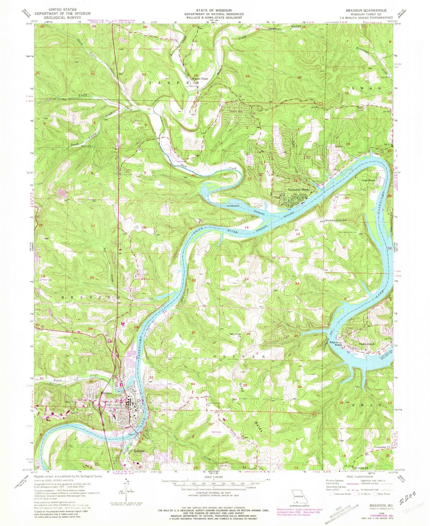
Classic USGS Branson Missouri 7.5'x7.5' Topo Map
Couldn't load pickup availability
Historical USGS topographic quad map of Branson in the state of Missouri. Typical map scale is 1:24,000, but may vary for certain years, if available. Print size: 24" x 27"
This quadrangle is in the following counties: Taney.
The map contains contour lines, roads, rivers, towns, and lakes. Printed on high-quality waterproof paper with UV fade-resistant inks, and shipped rolled.
Contains the following named places: Turkey Creek, Bee Creek, Coon Creek, Edgewater Beach, Howard Cemetery, Mountain Grove Cemetery, Mountain Grove School, Oak Grove Church (historical), Ozark Beach, Ozarks Memorial Park, Renshaw Cemetery, Silver Creek, Snapp Balds, Walnut Shade, Chula Vista, Ironside School (historical), Bee Creek School North (historical), Riverview School (historical), Long Beach, Saint James Church, Victor Church, Walnut Shade Cemetery, Walnut Shade Community Hall, Ozark Mountain Church, Cantwell Park, Boston Ferry Natural History Area, Missouri Conservation Department-Branson Headquarters, Mang Field, Branson Middle School, Branson Adult Community Center, Branson Public Library, Epps Park, Branson School, Sunset Park, Alexander Park, Mount Branson Christian Church, Kingdom Hall, Evangelical Free Church, Friendship Church, Edwards Cemetery, Merriam Woods, Silver Creek Lake, Branson Hills Church, The Church of Jesus Christ of Latter Day Saints, Branson Senior High School, Branson Junior High School, Eiserman Park, Parnell Park, Cox Medical Center, Branson City Cemetery, North Beach Park, Branson, Bear Creek, Bull Creek, Emory Creek, Gettman Hollow, North Emory Creek, Roark Creek, South Emory Creek, Lake Taneycomo, Rockaway Beach, KRZK-FM (Branson), Walnut Shade Post Office, Branson Post Office, Ozark Beach Dam, Rockwood Hills Lake Dam, Rockwood Hills Lake, Bull Creek, City of Rockaway Beach, Village of Bull Creek, Village of Kirbyville, Village of Merriam Woods, Murphy Park, Stockstill Park, Old School Park, Lakeside Forest Wilderness Area, Branson North Park, Nygard Park, Branson City Campground, Western Taney County Fire Protection District Station 5, Western Taney County Fire Protection District Station 6, Missouri Department of Conservation Forestry Southwest Regional Field Fire Office Branson, Western Taney County Fire Protection District Station 2, Branson Fire Department Station 1, Western Taney County Fire Protection District Station 7 Headquarters, Walnut Shade Golf Course (historical), Cedar Point Resort, Camp Leal (historical), Hollywood Hills (historical), Sunset Inn (historical), Palisades, Taneycomo Park (historical), Bee Creek Camp (historical), Camp Isaac Walton (historical), Young Mens Christian Association Camp (historical), Sleepy Hollow Camp (historical), Valley View (historical), Shore Acres (historical), Camp Ideal (historical), Camp Perfecto (historical), Sharps Log Cabin Camp (historical), Camp Roark (historical), Camp Ponca (historical), Sammy Lane Tourist Park (historical), Presbyterian Assembly (historical), Oak Wood (historical), Browns Landing (historical), Don Gardner Golf Course, Holiday Hills Golf Course, Payne Stewart Front Golf Course, Payne Stewart Back Golf Course, Branson Police Department, Rockaway Beach Police Department, Rockaway Beach Post Office


