MyTopo
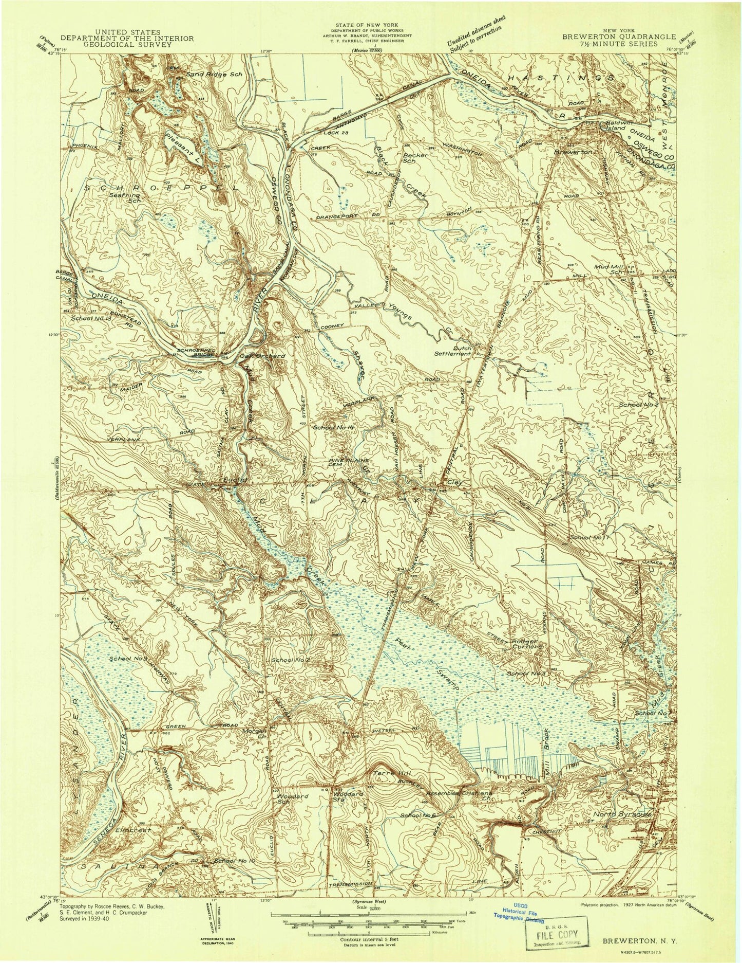
Classic USGS Brewerton New York 7.5'x7.5' Topo Map
Couldn't load pickup availability
Historical USGS topographic quad map of Brewerton in the state of New York. Map scale may vary for some years, but is generally around 1:24,000. Print size is approximately 24" x 27"
This quadrangle is in the following counties: Onondaga, Oswego.
The map contains contour lines, roads, rivers, towns, and lakes. Printed on high-quality waterproof paper with UV fade-resistant inks, and shipped rolled.
Contains the following named places: Airlane Enterprises Airport, Allen Road Elementary School, Andrews Memorial United Methodist Church, Anglican Church of Saint Mary, Anthony Cut, Bayberry, Bayberry Post Office, Beacon Baptist Church, Black Creek, Black Creek Road Bridge, Brewerton, Brewerton Census Designated Place, Brewerton Christian Church, Brewerton Elementary School, Brewerton Fire Department, Brewerton Post Office, Brewerton United Methodist Church, Buckley Landing Assisted Living Facility, Buckley Road Baptist Church, Calvary Baptist Church, Calvary Chapel of Syracuse, Casual Estates, Caughdenoy Volunteer Fire Department West Side Station, Christ the King Church, Church of God, Clay, Clay Fire Department, Clay Fire Training Center, Clay Post Office, Crawford School, Cross of Christ Lutheran Church, Denmans Island, Elmcrest, Elmcrest Elementary School, Euclid, Faith Gospel Tabernacle Church, Family Worship Center, Fort Brewerton State Park, Glosky Island, Grace Evangelical Covenant Church, Great Northern Mall Shopping Center, Immanuel Lutheran Church, Karl W Saile Bear Road Elementary School, King of Kings Lutheran Church, Kingdom Hall of Jehovahs Witnesses, Liverpool High School, Lock 23, Long Branch Elementary School, Luther Memorial Lutheran Church, Main Street Elementary School, Messiah Reformed Presbyterian Church, Michael Field-Onondaga Flight School Airport, Mill Brook, Morgan Cut, Morgan Road Elementary School, Morgan's Cemetery, Moyers Corner Fire Department, Mud Creek, Nazarene Community Church, North Area Volunteer Ambulance Corps, North Central Assembly of God, North Syracuse, North Syracuse Cemetery, North Syracuse Fire Department, North Syracuse Junior High School, North Syracuse Police Department, North Syracuse Post Office, North Syracuse Village Hall, Northern Onondaga Public Library at Brewerton, Northern Onondaga Public Library at North Syracuse, Northern Onondaga Volunteer Ambulance, Northminster Presbyterian Church, Northside Baptist Church, Oak Orchard, Ohsahaunytahseughka, Oneida River Bridge, Peat Swamp, Pine Plains Cemetery, Pleasant Lake, Redeemer Evangelical Covenant Church, Riveredge Airpark, Riverside Cemetery, Riverview Mobile Court, Rodger Corner, Saint Agnes Roman Catholic Church, Saint Johns Church, Saint Rose of Lima Church, Saint Rose School, Sandridge Cemetery, Schroeppel Bridge, Schroeppel Island, Shaver Creek, Skyline Country Club, Soule Road Middle School, Terre Hill, The Church of Jesus Christ of Latter Day Saints, Town of Clay, Tri - Bridge Marina, Trinity Assembly of God, Trinity Church, Trinity Evangelical Presbyterian Church, Trinity United Methodist Church, United Church, United Church of Christ, Village of North Syracuse, West Side Manor Adult Care Facility, Wetzel Road Church of Christ, Wetzel Road Elementary School, WEZG-FM (North Syracuse), WFBL-AM (Syracuse), Willow Field Elementary School, Winter Harbor Marina, Woodard, WXRA-AM (North Syracuse), Youngs, Youngs Creek, ZIP Codes: 13029, 13041, 13090, 13212