MyTopo
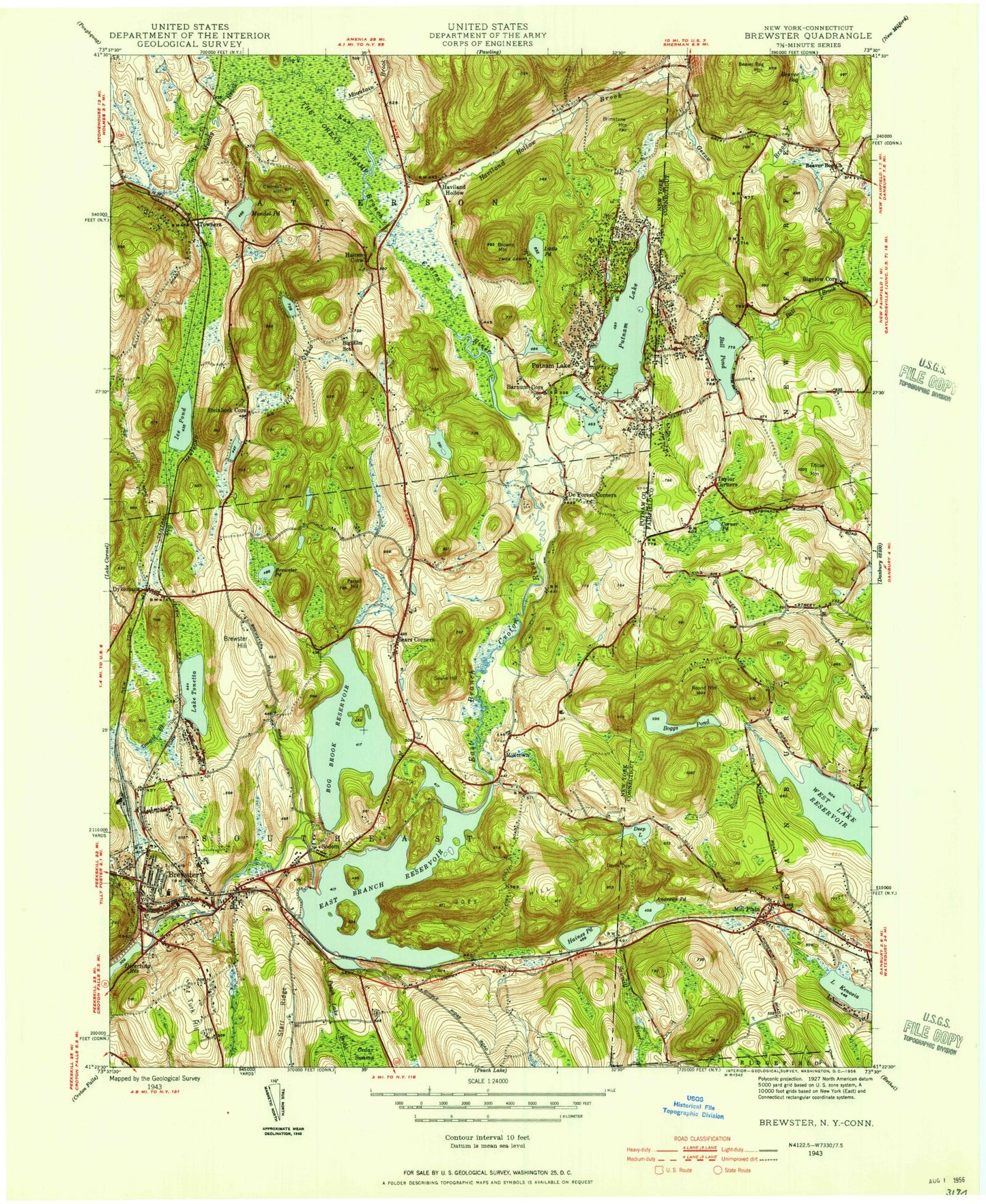
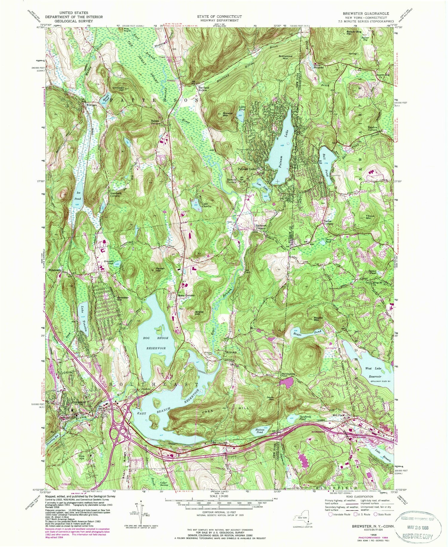
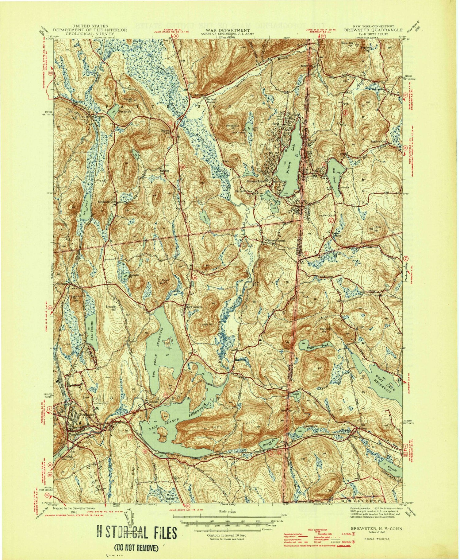
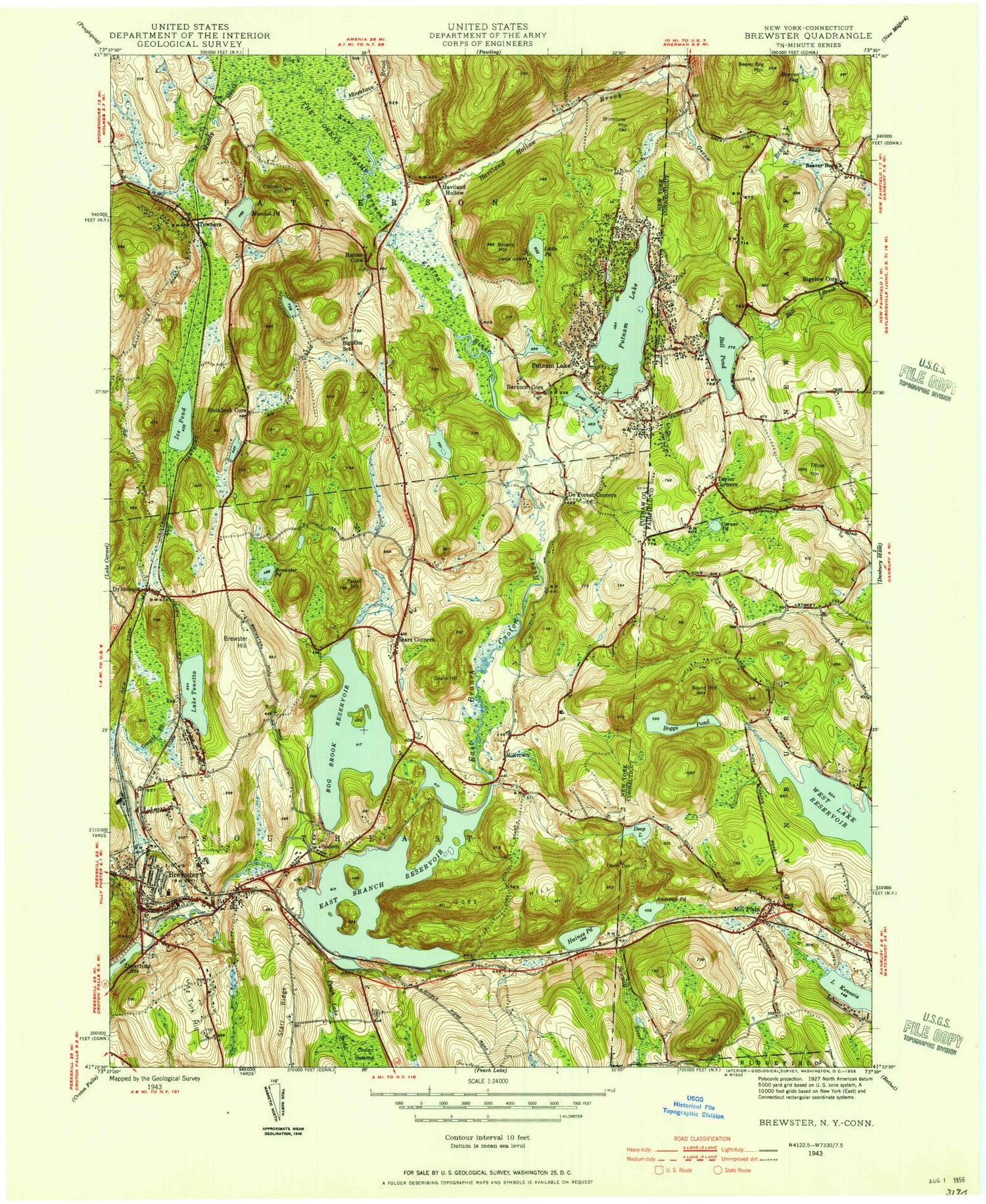
Classic USGS Brewster New York 7.5'x7.5' Topo Map
Couldn't load pickup availability
Historical USGS topographic quad map of Brewster in the states of New York, Connecticut. Typical map scale is 1:24,000, but may vary for certain years, if available. Print size: 24" x 27"
This quadrangle is in the following counties: Fairfield, Putnam.
The map contains contour lines, roads, rivers, towns, and lakes. Printed on high-quality waterproof paper with UV fade-resistant inks, and shipped rolled.
Contains the following named places: Salmons Daily Brook, Barnum Corners, Bog Brook Reservoir, Brewster, Brewster Hill, Brewster Pond, Brimstone Mountain, Browns Mountain, Cedar Swamp, Lake Charles, Cornwall Hill, Deforest Corners, Devils Den, Dykemans, East Branch Reservoir, Farrell Hill, Haines Corners, Haines Pond, Haviland Hollow Brook, Ice Pond, Joes Hill, Little Pond, Lost Lake, Mendel Pond, Milltown Cemetery, Mountain Brook, Muddy Brook, Peach Lake Brook, Putnam Lake, Putnam Lake, Sears Corners, Snake Hill, Sodom, Steinbeck Corners, Tonetta Brook, Lake Tonetta, Turk Hill, Starr Ridge, Haviland Hollow, Milltown, Towners, WPUT-AM (Brewster), Town of Patterson, Town of Southeast, Brewster Hill, Brewster High School, Henry W Wells Middle School, John F Kennedy Elementary School, Old Southeast Church, Longridge Corporate Park, Morefar Golf Club, Mount Ebo Corporate Center, Hillside Outdoor Education Center, Brewster Presbyterian Church, Saint Andrew's Episcopal Church, Saint Lawrence O'Toole Church, First Baptist Church of Brewster, First United Methodist Church, Saint Lawrence O'Toole School, Brewster Hill Census Designated Place, Putnam Lake Census Designated Place, Village of Brewster, Sacred Heart Roman Catholic Church, Doanesburgh (historical), Brewster Village Wastewater Treatment Plant, Brewster Heights Sewer District Sewage Treatment Plant, Grace Assembly of God, Iglesia Pentecostal Unida, Kingdom Hall of Jehovahs Witnesses, New Life Christian Church, Brewster Post Office, Putnam Ridge Nursing Home, Prospect Hill Road Bridge, Brewster Public Library, Marvin Peat Bed, Gayville, Mount Ebo, School Number 3 (historical), Elwell's Mills (historical), Corner Pond Brook, School Number 6 (historical), Brewster Fire Department, Couch Corners, Elm Tree Corner, School Number 5 (historical), Schoolhouse Number 3 (historical), Valleyville, School Number 4 (historical), Putnam Lake Volunteer Fire Department 2, Brush Hollow Cemetery, Haines Family Burial Ground, Townsend - Gilbert Cemetery, Barnum Cemetery, Saint Lawrence O'Toole Catholic Cemetery, Methodist Cemetery, Sears Burying Ground, Sherwood - Minor Cemetery, Ball Pond, Beaver Bog, Beaver Bog Church, Beaver Bog Mountain, Bigelow Corners, Boggs Pond, Corner Pond, Gerow Brook, Gerow Millpond, Lake Kenosia, King Street Church, Mill Plain, Round Mountain, Sawmill River, Sterns Pond, Taylor Corners, Titicus Mountain, West Lake Reservoir, Farringtons Pond, Sanfords Pond, Union Carbide Corp Heliport, Farringtons Pond Dam, Boggs Pond Dam, Ball Pond, Farringtons Park, Hidden Valley Nature Center, Kenosia Park, King Street School, Merton Mill Pond, New Fairfield High School, New Fairfield Middle School, Stanley Lasker Richter Memorial Park, Stanley Lasker Richter Municipal Golf Course, Mill Plain Volunteer Fire Company 12, Danbury Fire Department Engine 25, New Fairfield Volunteer Fire Department Ball Pond Fire Company, Beaver Bogs Cemetery, Union - Ball Pond Cemetery, King Street United Church Cemetery, Ball Pond Census Designated Place, Bigelow Corners Census Designated Place, Taylor Corners Census Designated Place, Taylor Corners Census Designated Place, Salmons Daily Brook, Barnum Corners, Bog Brook Reservoir, Brewster, Brewster Hill, Brewster Pond, Brimstone Mountain, Browns Mountain, Cedar Swamp, Lake Charles, Cornwall Hill, Deforest Corners, Devils Den, Dykemans, East Branch Reservoir, Farrell Hill, Haines Corners, Haines Pond, Haviland Hollow Brook, Ice Pond, Joes Hill, Little Pond, Lost Lake, Mendel Pond, Milltown Cemetery, Mountain Brook, Muddy Brook, Peach Lake Brook, Putnam Lake, Putnam Lake, Sears Corners, Snake Hill, Sodom, Steinbeck Corners, Tonetta Brook, Lake Tonetta, Turk Hill, Starr Ridge, Haviland Hollow, Milltown, Towners, WPUT-AM (Brewster), Town of Patterson, Town of Southeast, Brewster Hill, Brewster High School, Henry W Wells Middle School, John F Kennedy Elementary School, Old Southeast Church, Longridge Corporate Park, Morefar Golf Club, Mount Ebo Corporate Center, Hillside Outdoor Education Center, Brewster Presbyterian Church, Saint Andrew's Episcopal Church, Saint Lawrence O'Toole Church, First Baptist Church of Brewster, First United Methodist Church, Saint Lawrence O'Toole School, Brewster Hill Census Designated Place, Putnam Lake Census Designated Place, Village of Brewster, Sacred Heart Roman Catholic Church, Doanesburgh (historical), Brewster Village Wastewater Treatment Plant, Brewster Heights Sewer District Sewage Treatment Plant, Grace Assembly of God, Iglesia Pentecostal Unida, Kingdom Hall of Jehovahs Witnesses, New Life Christian Church, Brewster Post Office, Putnam Ridge Nursing Home, Prospect Hill Road Bridge, Brewster Public Library, Marvin Peat Bed, Gayville, Mount Ebo, School Number 3 (historical), Elwell's Mills (historical), Corner Pond Brook, School Number 6 (historical), Brewster Fire Department, Couch Corners, Elm Tree Corner, School Number 5 (historical), Schoolhouse Number 3 (historical), Valleyville, School Number 4 (historical), Putnam Lake Volunteer Fire Department 2, Brush Hollow Cemetery, Haines Family Burial Ground, Townsend - Gilbert Cemetery, Barnum Cemetery, Saint Lawrence O'Toole Catholic Cemetery, Methodist Cemetery, Sears Burying Ground