MyTopo
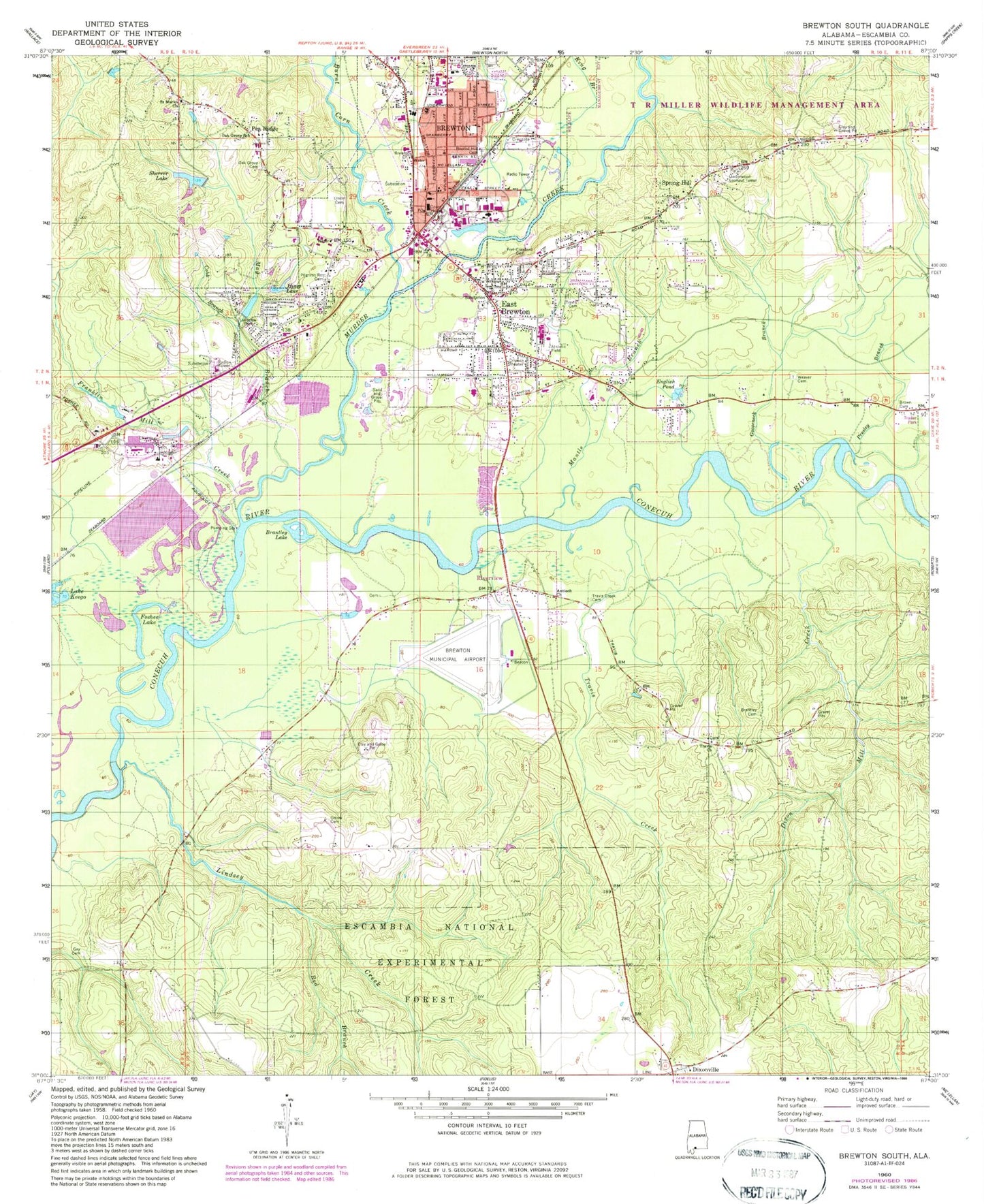
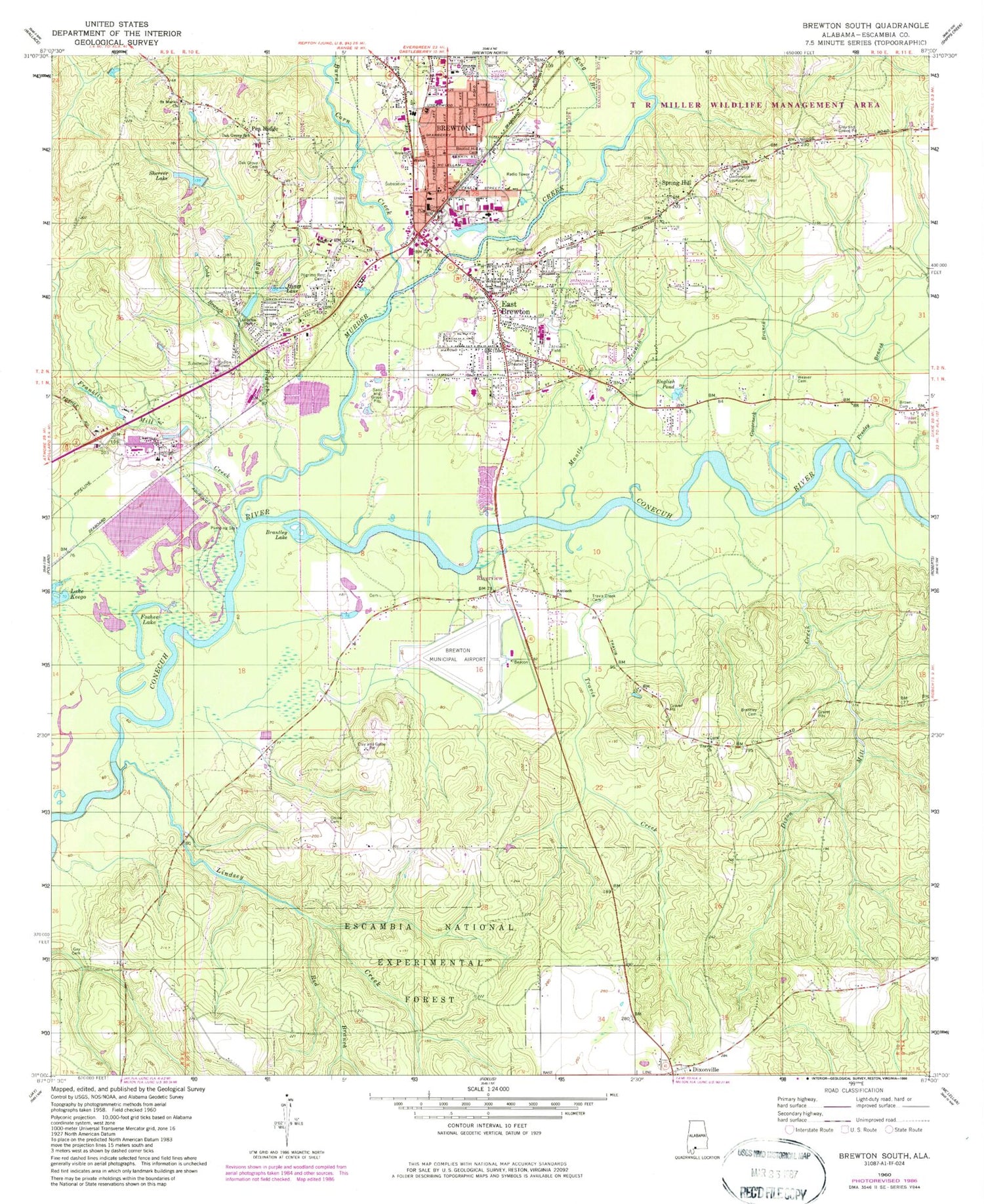
Classic USGS Brewton South Alabama 7.5'x7.5' Topo Map
Couldn't load pickup availability
Historical USGS topographic quad map of Brewton South in the state of Alabama. Map scale is 1:24000. Print size is approximately 24" x 27"
This quadrangle is in the following counties: Escambia.
The map contains contour lines, roads, rivers, towns, and lakes. Printed on high-quality waterproof paper with UV fade-resistant inks, and shipped rolled.
Contains the following named places: Ader Hill Church, Alco Baptist Church, Alco United Methodist Church, Antioch Church, Ashtown Pond, Baptist Hill Baptist Church, Baptist Hill Cemetery, Brantley Lake, Brewton, Brewton Elementary School, Brewton Fire Department, Brewton Grammer School (historical), Brewton Heights Shopping Center, Brewton High School, Brewton Historic Commercial District, Brewton Industrial Park, Brewton Municipal Airport, Brewton Pentecostal Holiness Church, Brewton Police Department, Brewton Post Office, Brewton Public Library, Brewton Revival Center, Brewton Sewage Lagoon, Brewton Sewage Lagoon Dam, Brown Cemetery, Burnt Corn Creek, Cedar Hill Baptist Church, Church of Christ, City of Brewton, City of East Brewton, Cobb Branch, Container Corporation Treatment Dam, Container Corporation Treatment P, Dixon Cemetery, Dixon Mill Creek, Dixonville, Dixonville Cemetery, Dixonville Volunteer Fire Department, Downing Industrial School (historical), East Brewton, East Brewton Church of God, East Brewton Fire Department, East Brewton Missionary Baptist Church, East Brewton Pentecostal Holiness Church, East Brewton Police Department, East Brewton Post Office, East Brewton Wastewater Treatment Plant, Edendale Church, English Pond, Escambia County Courthouse, Escambia County Fire and Rescue Squad, Escambia County Sheriff's Office, Escambia National Experimental Forest, Escambia-Brewton Area Vocational School, First Assembly of God Church, First Baptist Church, First Baptist Church of East Brewton, First Church of the Nazarene, First Presbyterian Church, First Saint Siloam Missionary Baptist Church, First United Methodist Church of Brewton, First United Methodist Church of East Brewton, Fort Crawford (historical), Fort Crawford Cemetery, Foshee Lake, Franklin Mill Creek, Gay Cemetery, Gooseneck Branch, Henley Bridge, Hines Lake, Holy Temple Church of God, Hortons Plaza Shopping Center, Jefferson Davis Community College, King Branch, Lake Keego, Lakeview Park, Liberty Fellowship Church, Lindsey Creek, Mantle Branch, May Branch, Mount Zion African Methodist Episcopal Church, Murder Creek, Nathansville Post Office (historical), Oak Grove Cemetery, Oak Grove Junior High School, Odie Sherrer Dam, Odom Cemetery, Pea Ridge, Pilgrims Rest (historical), Pilgrims Rest Cemetery, Prayer House Church of God in Christ, Presley Branch, Red Branch, Red Branch, Ridge Road Baptist Church, Riverview, Saint Marks Church, Second Saint Johns Baptist Church, Second Saint Siloam Missionary Baptist Church, Sherrer Lake, Shiloah United Methodist Church, Spring Hill, Spring Hill Cemetery, Thomas E McMillan Museum, Town of Riverview, Travis Cemetery, Travis Church, Travis Creek, Travis Creek Cemetery, Travis School (historical), Travis Toll Bridge (historical), Triumph the Church and Kingdom of God in Christ, Underwood Lookout Tower, Union Cemetery, Universalist Church, W S Neal High School, Weaver Cemetery, WEBJ-AM (Brewton), West Gate Village Nursing Home, WKNU-FM (Brewton), Zion Fountain African Methodist Episcopal Church