MyTopo
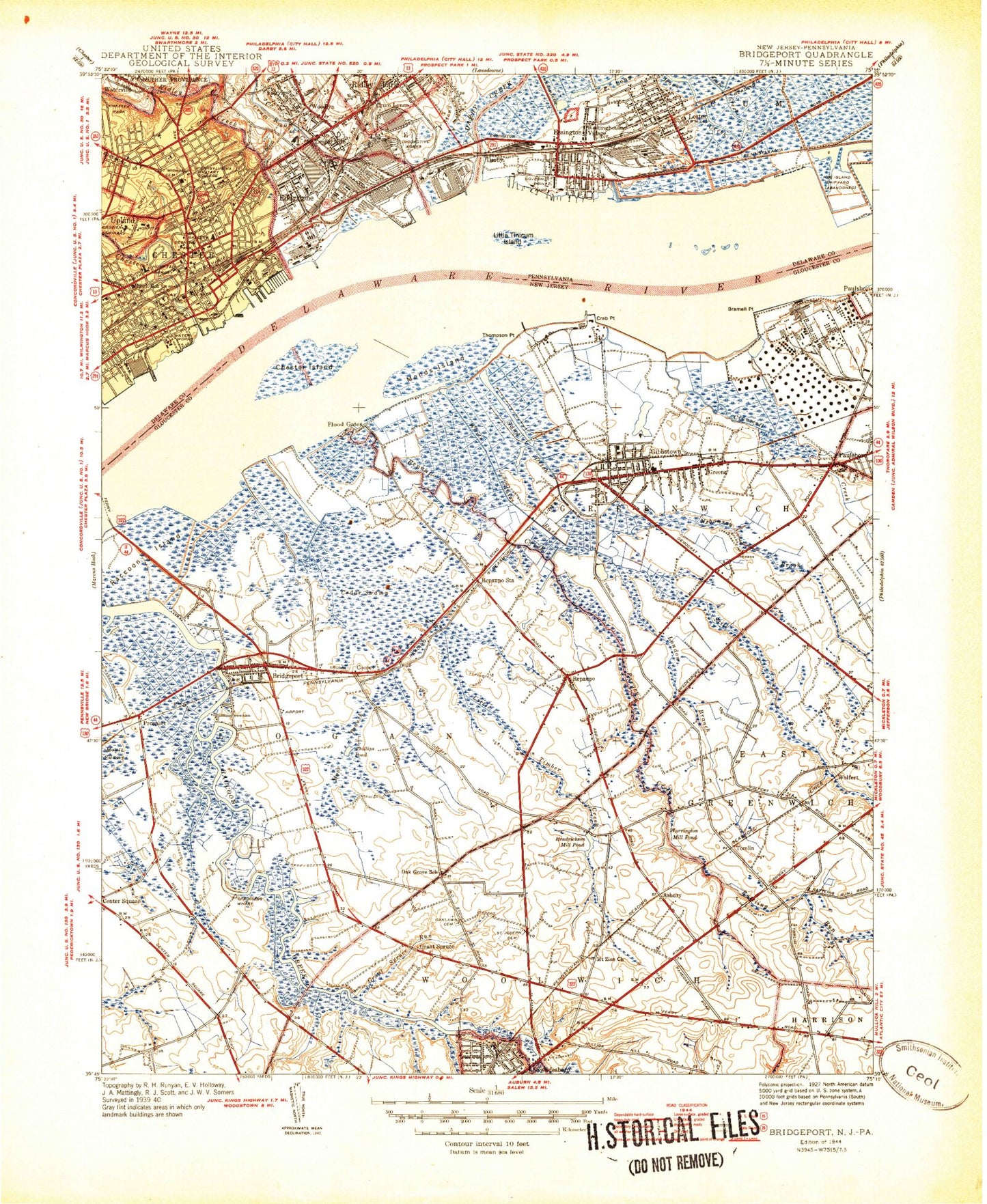
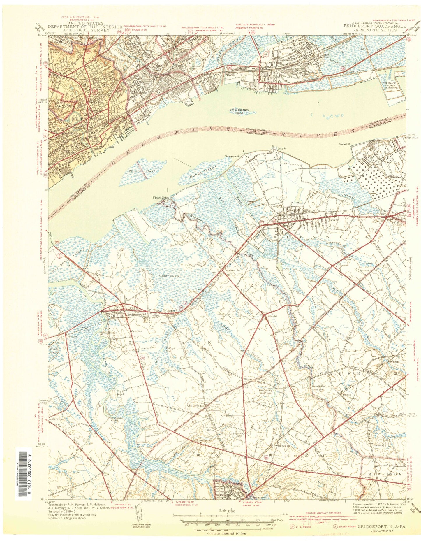
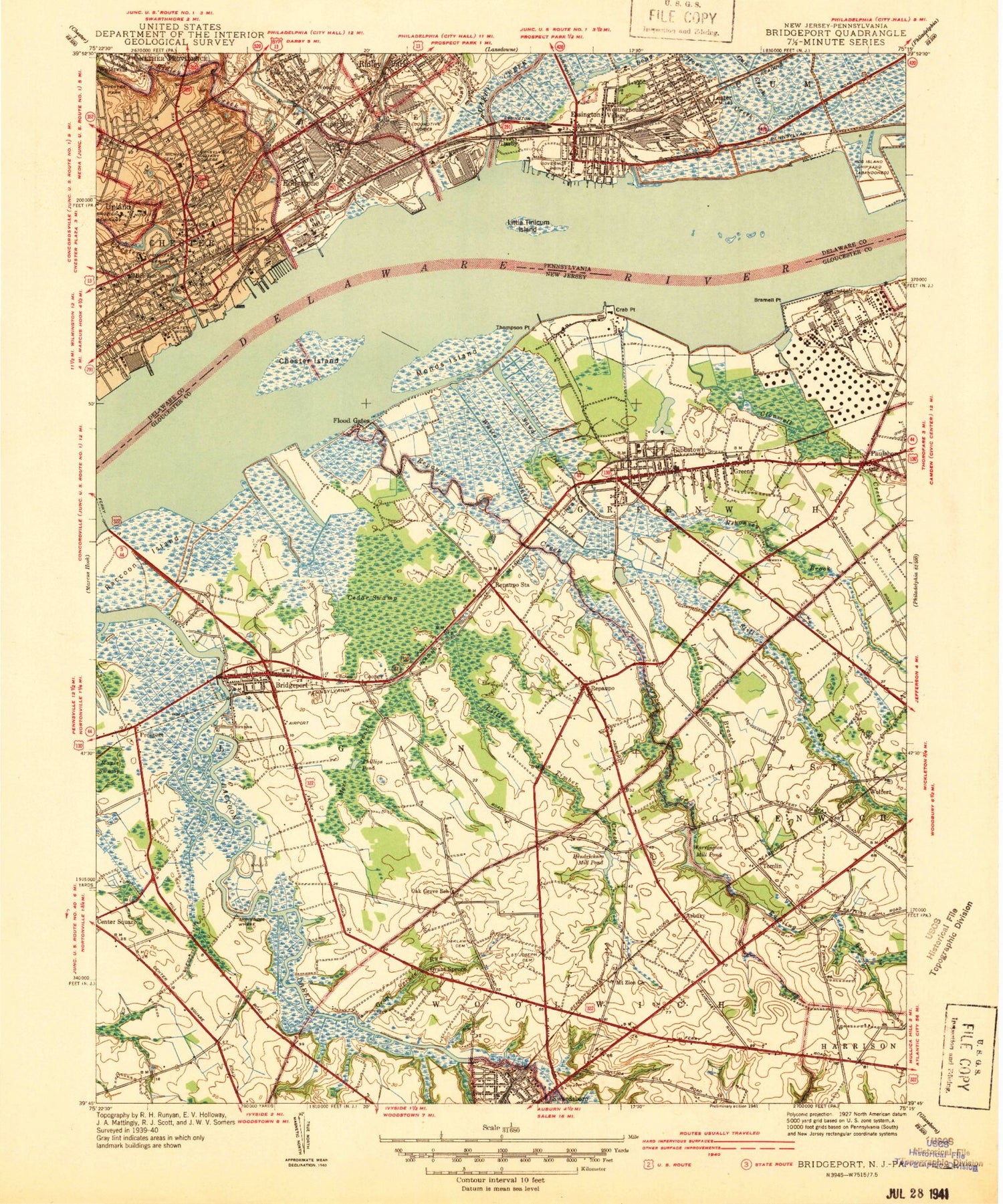
Classic USGS Bridgeport New Jersey 7.5'x7.5' Topo Map
Couldn't load pickup availability
Historical USGS topographic quad map of Bridgeport in the states of New Jersey, Pennsylvania. Map scale is 1:31680. Print size is approximately 24" x 27"
This quadrangle is in the following counties: Delaware, Gloucester.
The map contains contour lines, roads, rivers, towns, and lakes. Printed on high-quality waterproof paper with UV fade-resistant inks, and shipped rolled.
Contains the following named places: Asbury, Asbury, Aunt Debs Ditch, Aunt Debs Ditch, Baldwin, Baldwin Station, Beckett, Beckett Census Designated Place, Billingsport Range, Billingsport Range, Blessed Katharine Drexel Church, Boeing Fire Department, Boeing-Vertol Company Center Three South Heliport, Borough of Eddystone, Bramell Point, Bramell Point, Bridgeport, Bridgeport, Bridgeport (historical), Bridgeport Census Designated Place, Bridgeport Post Office, Bridgeport Speedway, Bridgeport Volunteer Fire Department, Bridgeport Volunteer Fire Department Station 2, Bridgeport-Cahill Field, Broad Street Elementary School, Calcon Hook (historical), Cedar Swamp, Cedar Swamp, Center Square Elementary School, Chester, Chester City Fire Company Station 82, Chester Creek, Chester Friends Cemetery, Chester High School, Chester Island, Chester Island, Chester Park, Chester Police Department, Chester Post Office, Chester Range, Chester Range, Chester Rural Cemetery, Chester Station, Christopher Columbus Elementary School, Church Run, City of Chester, Clonmell Creek, Clonmell Creek, Cooper, Cooper, Cooper Lake, Cooper Lake, Crab Point, Crab Point, Crosbyville, Crozer - Chester Medical Center, Crozer Chester Medical School, Crozer Seminary, Crum Creek, Crum Lynne, Crum Lynne Post Office, Crumlynn Station, Curtis Pit, Darby Creek, Darby Creek, Deshong Park, Doctor Chester I Ulmer Park, East Greenwich Township Police Department, Eddystone, Eddystone Borough Hall, Eddystone Elementary School, Eddystone Fire Company Station 12, Eddystone Police Department, Eddystone Police Department, Eddystone Range, Eddystone Range, Eddystone Station, Essington, Essington Company 1 Fire Station, Essington Post Office, Excelsior Bar, Exelon Fire Company, Fairview, Franklin School, Gibbstown, Gibbstown, Gibbstown Census Designated Place, Gibbstown Post Office, Gibbstown Volunteer Fire Company, Gloucester County Emergency Medical Services Station 80 - 1, Governor Printz Park, Grand Sprute, Grand Sprute, Grand Sprute Run, Grand Sprute Run, Greenwich Elementary School, Greenwich Lake, Greenwich Lake, Greenwich Lake Park, Greenwich Township Branch Library, Greenwich Township Building, Greenwich Township Little League Ball Fields, Greenwich Township Park, Greenwich Township Police Department, Guardian Angels Regional Catholic School, Guardian Angels Regional Catholic School, Hendrickson Mill Dam, Hendrickson Millpond, Hendrickson Millpond, Hercules Heliport, Jefferis School, Keystone Center, Kingsway Regional High School, Kingsway Regional High School, Kingsway Regional Middle School, Larkin School, Lazaretto Cemetery, Leedom Estates, Leedom Fire Company Station 70, Leiperville, Leiperville School, Lester, Lester Fire Station, Lester School, Lincoln School, Little Crum Creek, Little Timber Creek, Little Timber Creek, Little Tinicum Island, Logan Elementary School, Logan Plant Heliport, Logan Township Police Department, London Branch, London Branch, Louis Silvastro Lake Park, Maple Swamp, Maple Swamp, Mickleton Post Office, Middle Creek (historical), Monds Island, Monds Island, Morton Street School, Moss Branch, Moss Branch, Mount Zion Church, Mount Zion Church, Nehaunsey Middle School, Nehonsey Brook, Nehonsey Brook, Oaklawn Cemetery, Oaklawn Cemetery, Old Canal, Old Chester Courthouse, Pargey Creek, Pargey Creek, Paulsboro Refinery, Pennsylvania Mil College, Phillips Pond, Phillips Pond, Plum Hook Creek (historical), Prospect, Prospect, Raccoon Island, Raccoon Island, Rattling Run, Rattling Run, Repaupo, Repaupo, Repaupo Creek, Repaupo Creek, Repaupo Station, Repaupo Station, Repaupo Volunteer Fire Company, Ridley Creek, Ridley Park Police Department, Rulon Road, Rulon Road, S M Vauclain Fire Company, Saint Anthonys School, Saint James High School, Saint Josephs Cemetery, Saint Josephs Cemetery, Saint Margaret Mary Alacoque Church Cemetery, Saint Margaret Marys School, Saint Michaels Roman Catholic Cemetery, Saint Michaels School, Saint Pauls Burying Ground, Saint Roberts School, Sand Ditch, Sand Ditch, Smedley Middle School, Solomons Graveyard, Solomons Graveyard, Springers Wharf, Springers Wharf, State Correctional Institution Chester, Stetser School, Still Run, Still Run, Stony Creek, Taylor Arboretum, Thompson Point, Thompson Point, Tinicum Elementary School, Tinicum Industrial Park, Tinicum Island (historical), Tinicum Library, Tinicum Range, Tinicum Range, Tinicum Township Building, Tinicum Township Census Designated Place, Tinicum Township Fire Company Station 48, Tinicum Township Police Department, Tinicum Township Police Department, Tomlin, Township of Greenwich, Township of Logan, Township of Tinicum, Union Cemetery, Union Church, Warrington Mill Dam, Warrington Millpond, Washington Park, Waterville, WDNR-FM (Chester), Westinghouse Village, Wetherill School, White Sluice Race, Widener University Post Office, Widener University Technology Park, William Penns Landing Site (historical), Wolfert, Woodlyn, Woodlyn Police Department, Woodlyn Shopping Center