MyTopo
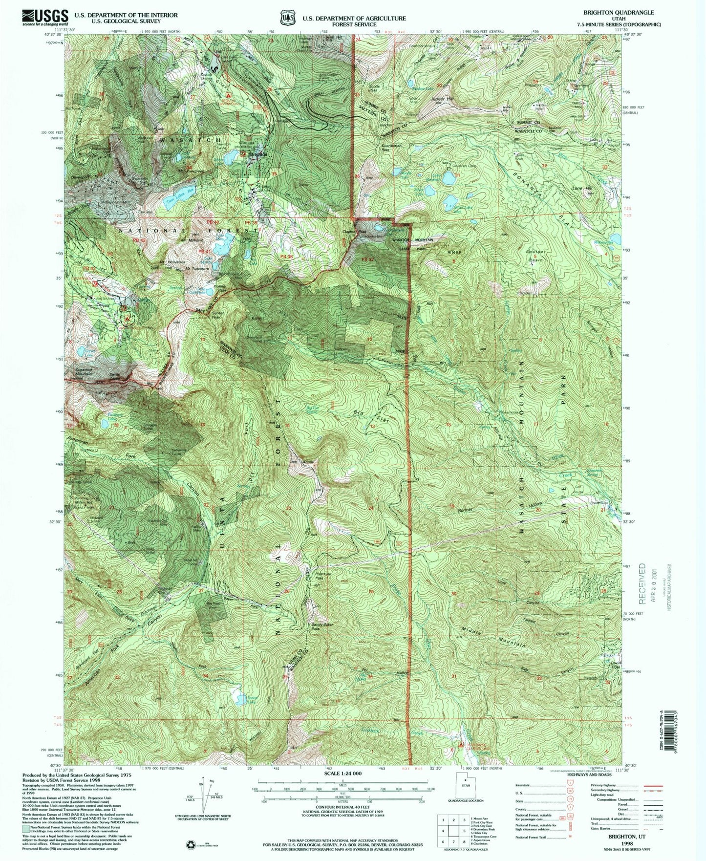
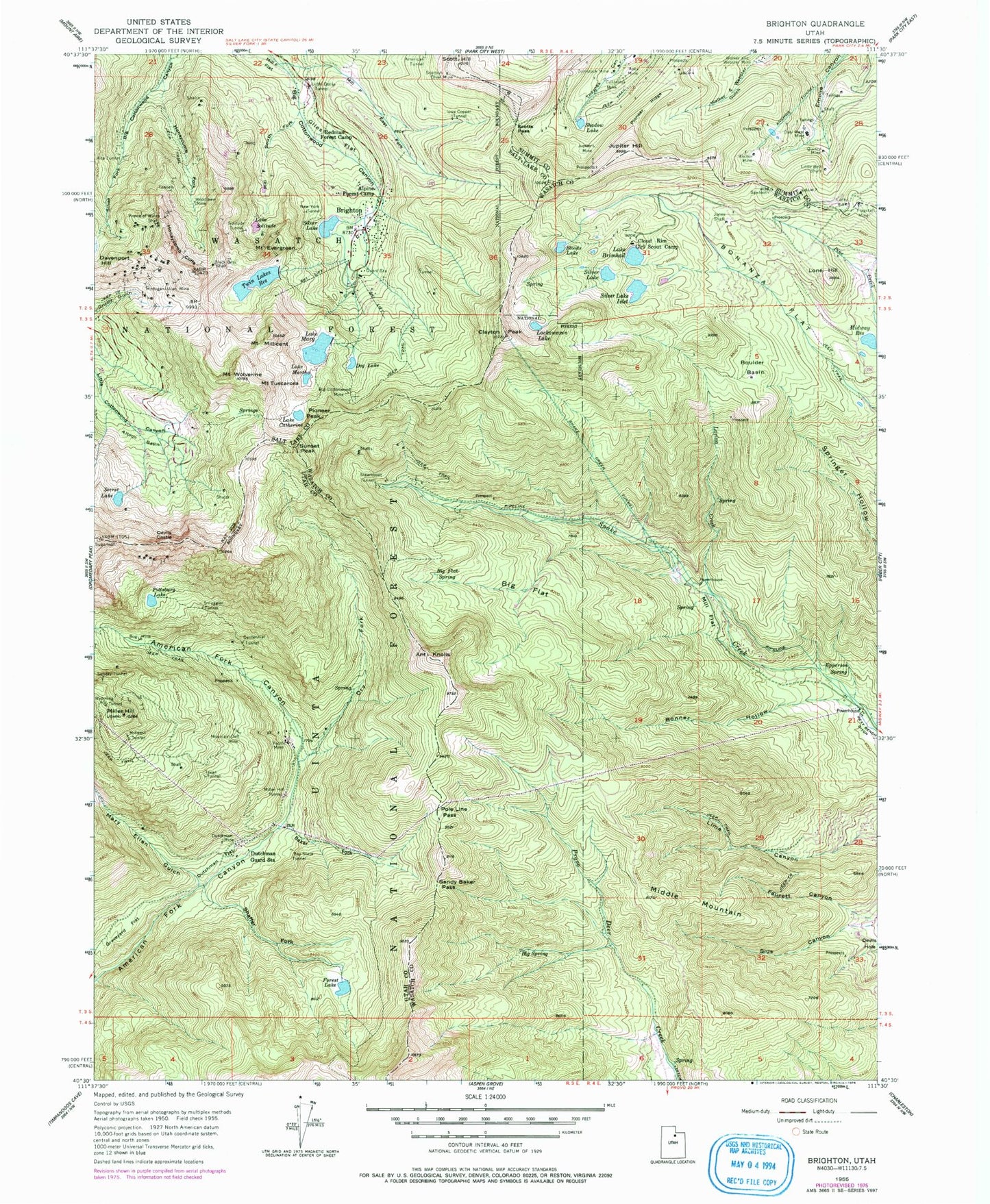
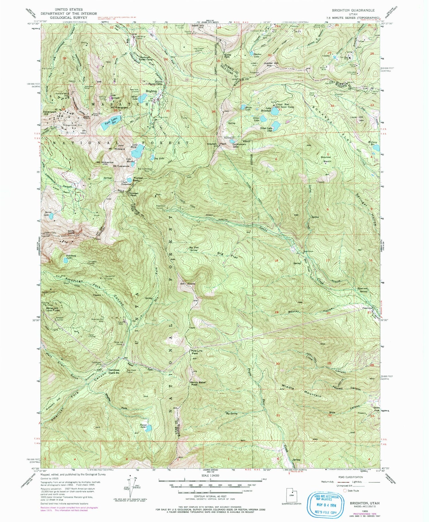
Classic USGS Brighton Utah 7.5'x7.5' Topo Map
Couldn't load pickup availability
Historical USGS topographic quad map of Brighton in the state of Utah. Typical map scale is 1:24,000, but may vary for certain years, if available. Print size: 24" x 27"
This quadrangle is in the following counties: Salt Lake, Summit, Utah, Wasatch.
The map contains contour lines, roads, rivers, towns, and lakes. Printed on high-quality waterproof paper with UV fade-resistant inks, and shipped rolled.
Contains the following named places: Albion Basin, Alpine Forest Camp, Alta Tunnel, American Tunnel, Anchor Mine, Anchor Tunnel, Ant Knolls, Apex Mine, Baker Fork, Bay State Tunnel, Big Cottonwood Mine, Big Flat, Big Flat Spring, Big Spring, Black Bess Shaft, Bloods Lake, Bog Mine, Bonanza Flat, Bonner Hollow, Boulder Basin, Brighton, Lake Brimhall, California Mine, Lake Catherine, Centennial Tunnel, Clayton Peak, Cloud Rim Girl Scout Camp, Comstock Mine, Daly West Mine, Davenport Hill, Devils Castle, Dog Lake, Dry Fork, Dutchman Guard Station, Dutchman Mine, Epperson Spring, Mount Evergreen, Faucett Canyon, Flagstaff Mine, Forest Lake, Giles Flat, Graveyard Flat, Honeycomb Cliffs, Honeycomb Fork, Iowa Copper Tunnel, Jones Shaft, Jupiter Hill, Jupiter Mine, Lackawaxen Lake, Lavina Creek, Lime Canyon, Little Bell Shaft, Little Dollie Tunnel, Lone Hill, Lucky Bill, Lake Martha, Mary Ellen Gulch, Lake Mary, Michigan-Utah Mine, Middle Mountain, Midway Reservoir, Midwest Tunnel, Mill F East Fork, Mill F South Fork, Mill Flat, Miller Hill, Miller Hill Tunnel, Mount Millicent, Mountain Dell Mine, New York Tunnel, Pacific Mine, Pioneer Peak, Pioneer Ridge, Pittsburg Lake, Pole Line Pass, Prince of Wales Shaft, Quincy Mine, Redman Forest Camp, Sandy Baker Pass, Scott Hill, Scottish Chief Mine, Scotts Pass, Secret Lake, Shadow Lake, Shaffer Fork, Sids Canyon, Silver Lake, Silver Lake, Smuggler Tunnel, Snake Creek Tunnel, Solitude Tunnel, Lake Solitude, Steamboat Tunnel, Sunday Tunnel, Sunset Peak, Texan Tunnel, Mount Tuscarora, Twin Lakes Reservoir, USLM 4 Mine, Walker and Webster Mine, Mount Wolverine, Woodlawn Mine, Wyoming Tunnel, Lake Mary Dam, Silver Lake Islet, Silver Lake Islet Dam, Silver Lake Dam, Twin Lakes Dam, Brighton Ski Area Heliport, Solitude Ski Area Heliport, The Church of Jesus Christ of Latter Day Saints, Brighton Ski Resort, Deer Creek Campground, Lady of the Lake, Silver Lake Estates, Albion Alps, Albion Basin, Albion Basin Campground, Brighton Guard Station, Brighton Recreation Area, Brighton Ski Area, Guardsman Pass, Lundeen Creek, Pot Hollow, Solitude, Sugarloaf Mountain, Brighton Post Office (historical), Town of Alta, Unified Fire Authority Station 108, Town of Brighton