MyTopo
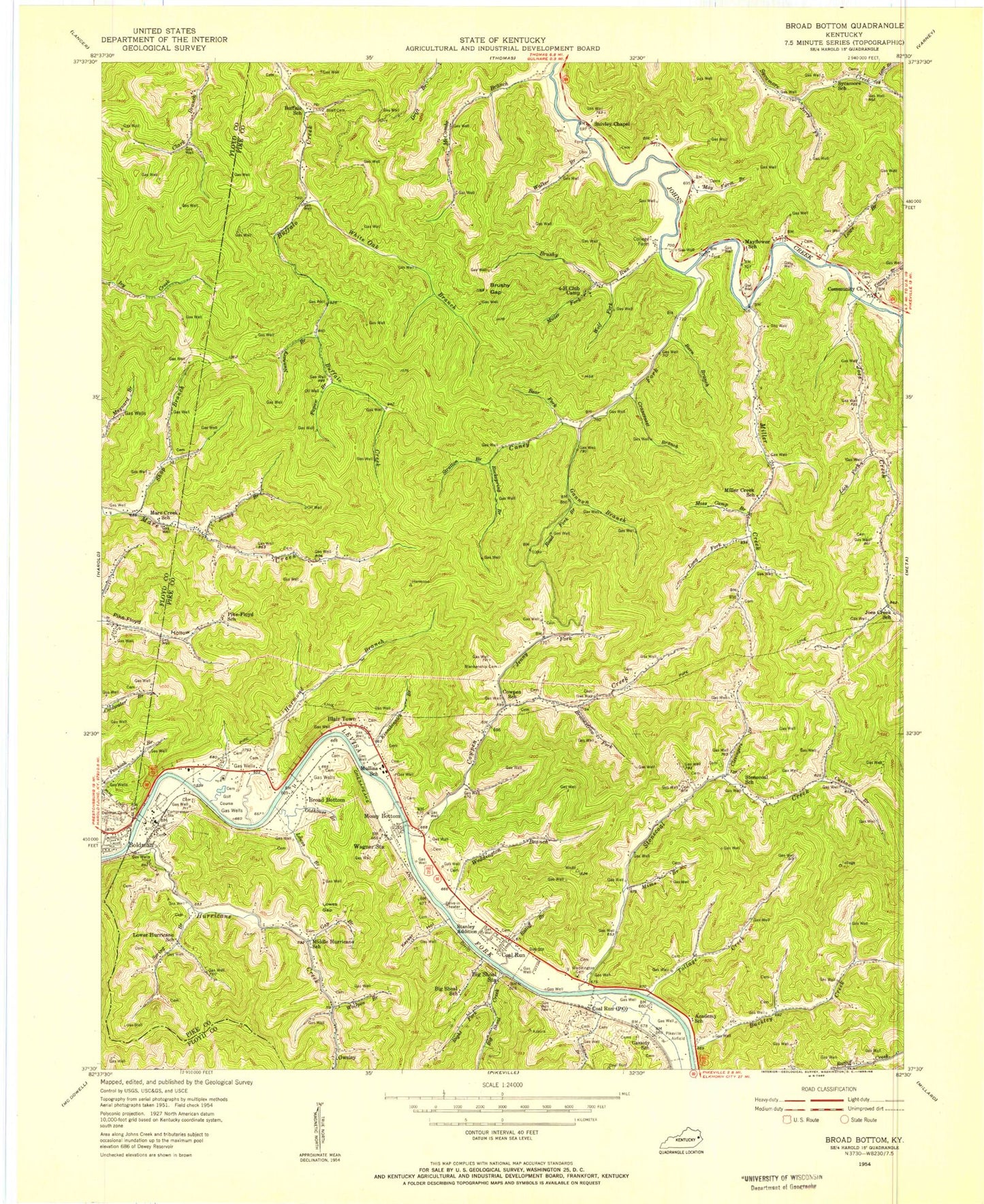
Classic USGS Broad Bottom Kentucky 7.5'x7.5' Topo Map
Couldn't load pickup availability
Historical USGS topographic quad map of Broad Bottom in the state of Kentucky. Map scale may vary for some years, but is generally around 1:24,000. Print size is approximately 24" x 27"
This quadrangle is in the following counties: Floyd, Pike.
The map contains contour lines, roads, rivers, towns, and lakes. Printed on high-quality waterproof paper with UV fade-resistant inks, and shipped rolled.
Contains the following named places: 4-H Club Camp, Barn Branch, Bear Fork, Big Shoal, Big Shoal Creek, Big Shoal Post Office, Big Shoal School, Big Shoal Station, Blair Cemetery, Blair Town, Blankenship Cemetery, Boldman, Boldman Bridge, Boldman School, Broad Bottom, Broomstraw Fork, Brushy Gap, Brushy Run, Buckley Creek, Buffalo School, Cabin Branch, Caney Fork, Cassidy School, Christ Central School, City of Coal Run Village, Clevingers Branch, Coal Run Hill, Coal Run Post Office, Coal Run Railroad Station, Coal Run School, Coal Run Village, Coal Run Village Police Department, Coal Run Village Volunteer Fire Department, Cold Run Bridge, College Farm, Community Church, Cow Pen Church, Cowpen Creek, Cowpen School, Cranesnest Branch, Crossroads Shopping Center, Cushaw Branch, Cynthiann Church, Damron Cemetery, Deskins Hollow, Diaz Post Office, Edmonds Hollow, Fox Bottom, Freedom Church, Gannon Branch, Gap Branch, Hamlack, Hamlack Railroad Station, Harmond Branch, Holy Spirit Lutheran Church, Honaker Academy, Horse Pen Branch, Hurricane Creek, Hurricane Creek Volunteer Fire Department, Hurricane Creek Volunteer Fire Department Station 2, Immanuel Baptist Church, Jake Post Office, Jenny Fork, Jerry Fork, Jimmy Branch, Joe Post Office, Joes Creek, Joes Creek School, John Post Office, Johns Post Office, Kelthly Fork, Kentucky State Police Post 9, Keyser Heights, Keyser Hollow, Keyser Post Office, Keyser Railroad Station, Kinnikinnick Branch, Lackens Branch, Lake Joann, Laura Church, Liberty Hope Church, Lick Fork, Little Floyd County, Little Minnie Church, Long Branch, Long Fork, Lowe Branch, Lower Hurricane School, Lowes Branch, Lowes Gap, Mare Creek Church, Mare Creek School, Marrs Cemetery, May Cemetery, May Farm Branch, May Flower Post Office, Mayflower Church, Mayflower School, McCombs Branch, Middle Hurricane School, Miller Creek, Miller Creek School, Miller Fork, Mims Branch, Moss Camp Branch, Mossy Bottom, Mossy Bottom Bridge, Mossy Bottom School, Mullins Cemetery, Mullins School, Nunnary Branch, Oldhouse Branch, Owsley, Owsley Church, Owsley Post Office, Papaw Branch, Pike County Airport-Hatcher Field, Pike-Floyd School, Pikeville Airfield, Pikeville Division, Pikeville Post Office, Pikeville Sportsman Club, Pinson Branch, Pinson Cemetery, Ratliff Branch, Right Fork Big Shoal Creek, Road Fork Branch, Rockspring Branch, Scalf Cemetery, Sharondale Railroad Station, Shop Branch, Snivley Chapel, Spring Branch, Stanley, Stanley Addition, Stonecoal Church, Stonecoal Creek, Stonecoal School, Stratton Branch, Sycamore School, Tollage Creek, Victory Church, Wagner Station, Wagoner, Wagoner Church, Walker Branch, Wedding Plaza Shopping Center, Wedding Square Shopping Center, Weddington Branch, Weddington Cemetery, White Oak Branch, Wolf Fork, Wolfpen Branch, Woodlands Acres, ZIP Codes: 41501, 41605, 41659