MyTopo
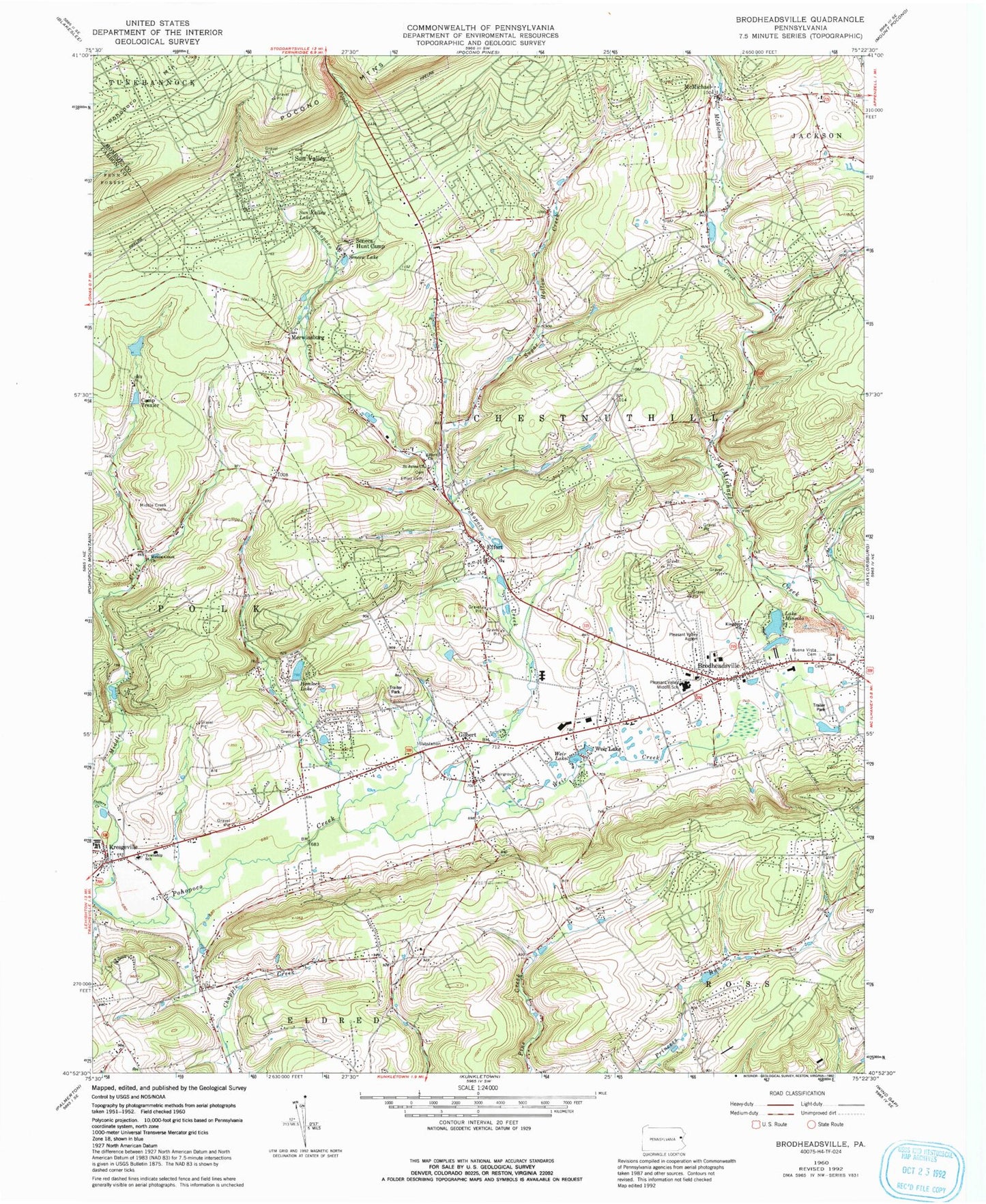
Classic USGS Brodheadsville Pennsylvania 7.5'x7.5' Topo Map
Couldn't load pickup availability
Historical USGS topographic quad map of Brodheadsville in the state of Pennsylvania. Typical map scale is 1:24,000, but may vary for certain years, if available. Print size: 24" x 27"
This quadrangle is in the following counties: Carbon, Monroe.
The map contains contour lines, roads, rivers, towns, and lakes. Printed on high-quality waterproof paper with UV fade-resistant inks, and shipped rolled.
Contains the following named places: Brodheadsville, Buena Vista Cemetery, Camp Trexler, Effort, Hillside Memorial Cemetery, Effort Church, Fall Creek, Gilbert, Hemlock Lake, Kingdom Church, McMichael, Middle Creek Cemetery, Middle Creek Church, Lake Mineola, Saint Johns Church, Seneca Hunt Camp, Seneca Lake, Sugar Hollow Creek, Sun Valley, Sun Valley Lake, Weir Creek, Weir Lake, Weir Lake, Pohopco Mountains, Zion Church, Hypsy Creek, Poplar Creek, Pleasant Valley Airport (historical), Hemlock Lake Dam, Camp Trexler Dam, Sun Valley Dam, Weir Mountain, Dotters Creek, Merwinsburg, Vista Estates, Chestnut Lake Campground, Country Terrace Acres, Robinhood Country Estates, Pleasant Valley Middle School, John C Mills Elementary School, Chestnuthill Elementary School, Weir Lake Dam, Polk Township Elementary School, Mexico School (historical), Gower School, Michael Valley School, Pleasant View Lake, Pleasant Valley High School, Township of Chestnuthill, Brodheadsville Census Designated Place, Effort Census Designated Place, Sierra View Census Designated Place, Sun Valley Census Designated Place, West End Fire Company Station 43 Mount Effort, West End Fire Company Station 43 Sun Valley, West End Fire Company Station 43, Gilbert Post Office, Brodheadsville Post Office, Effort Post Office, Kresgeville Post Office, Gilbert Cemetery, McMichaels Cemetery, Old Brodheadsville Cemetery, Brodheadsville, Buena Vista Cemetery, Camp Trexler, Effort, Hillside Memorial Cemetery, Effort Church, Fall Creek, Gilbert, Hemlock Lake, Kingdom Church, McMichael, Middle Creek Cemetery, Middle Creek Church, Lake Mineola, Saint Johns Church, Seneca Hunt Camp, Seneca Lake, Sugar Hollow Creek, Sun Valley, Sun Valley Lake, Weir Creek, Weir Lake, Weir Lake, Pohopco Mountains, Zion Church, Hypsy Creek, Poplar Creek, Pleasant Valley Airport (historical), Hemlock Lake Dam, Camp Trexler Dam, Sun Valley Dam, Weir Mountain, Dotters Creek, Merwinsburg, Vista Estates, Chestnut Lake Campground, Country Terrace Acres, Robinhood Country Estates, Pleasant Valley Middle School, John C Mills Elementary School, Chestnuthill Elementary School, Weir Lake Dam, Polk Township Elementary School, Mexico School (historical), Gower School, Michael Valley School, Pleasant View Lake, Pleasant Valley High School, Township of Chestnuthill, Brodheadsville Census Designated Place, Effort Census Designated Place, Sierra View Census Designated Place, Sun Valley Census Designated Place, West End Fire Company Station 43 Mount Effort, West End Fire Company Station 43 Sun Valley, West End Fire Company Station 43, Gilbert Post Office, Brodheadsville Post Office, Effort Post Office, Kresgeville Post Office, Gilbert Cemetery, McMichaels Cemetery, Old Brodheadsville Cemetery