MyTopo
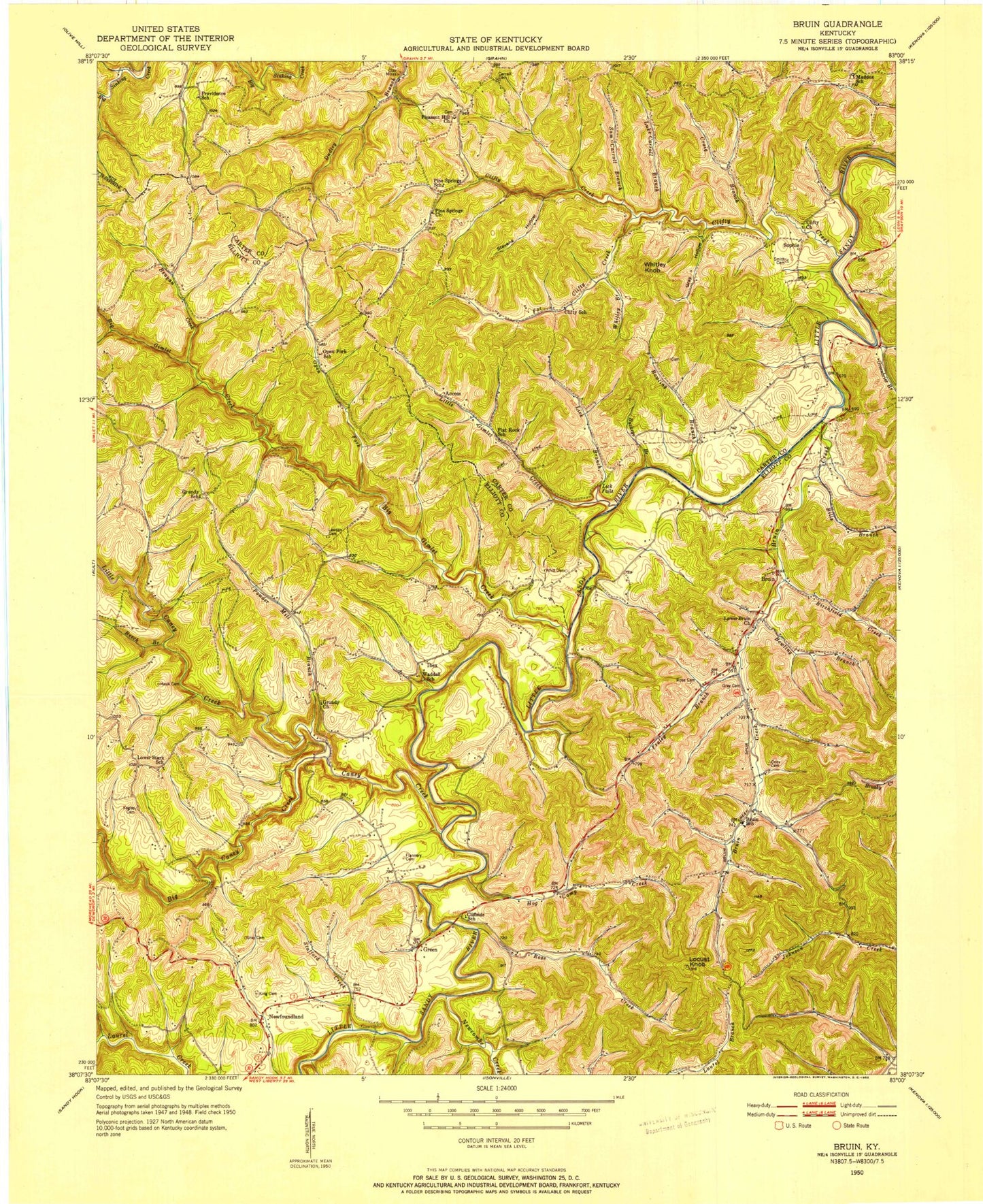
Classic USGS Bruin Kentucky 7.5'x7.5' Topo Map
Couldn't load pickup availability
Historical USGS topographic quad map of Bruin in the state of Kentucky. Map scale is 1:24000. Print size is approximately 24" x 27"
This quadrangle is in the following counties: Carter, Elliott.
The map contains contour lines, roads, rivers, towns, and lakes. Printed on high-quality waterproof paper with UV fade-resistant inks, and shipped rolled.
Contains the following named places: Access, Access, Bat Williams Flat, Bat Williams Flat, Bear Flats, Bear Flats, Beech Branch, Beech Branch, Benyan Creek, Benyan Creek, Bet Post Office (historical), Bet Post Office (historical), Big Caney Creek, Big Caney Creek, Big Gimlet Creek, Big Gimlet Creek, Bills Branch, Bills Branch, Birchfield Creek, Birchfield Creek, Boggs Cemetery Two, Boggs Cemetery Two, Bowling Branch, Bowling Branch, Bowling Branch, Bowling Branch, Brokers Neck Ridge, Brokers Neck Ridge, Bruin, Bruin, Bruin Creek, Bruin Creek, Bruin Post Office (historical), Bruin Post Office (historical), Bruin School (historical), Bruin School (historical), Buckeye Branch, Buckeye Branch, Caney Creek, Caney Creek, Carroll Cemetery, Carroll Cemetery, Chalybeate Spring, Chalybeate Spring, Citico Fire Department, Citico Fire Department, Cliffside School (historical), Cliffside School (historical), Clifty (historical), Clifty (historical), Clifty Creek, Clifty Creek, Clifty School (historical), Clifty School (historical), Craig Creek, Craig Creek, Crisco Post Office (historical), Crisco Post Office (historical), Far Clifty Creek, Far Clifty Creek, Flannery Cemetery, Flannery Cemetery, Flannery Cemetery (historical), Flannery Cemetery (historical), Flannery Flats, Flannery Flats, Flat Rock School (historical), Flat Rock School (historical), Fraley Branch, Fraley Branch, Gray Cemetery, Gray Cemetery, Gray Cemetery (historical), Gray Cemetery (historical), Gray Hollow, Gray Hollow, Grayson Lake, Grayson Lake, Grayson Lake State Park, Grayson Lake State Park, Grayson Lake Wildlife Management Area, Grayson Lake Wildlife Management Area, Green, Green, Green Bridge, Green Bridge, Green Post Office (historical), Green Post Office (historical), Greenbrier Branch, Greenbrier Branch, Grundy Church, Grundy Church, Grundy School (historical), Grundy School (historical), Hog Camp Creek, Hog Camp Creek, Horton Flat, Horton Flat, Horton Flat, Horton Flat, Ibex, Ibex, Kegley Cemetery, Kegley Cemetery, Kentucky Gap, Kentucky Gap, King Cemetery, King Cemetery, Klein Post Office (historical), Klein Post Office (historical), Lakeside School, Lakeside School, Lawson Cemetery, Lawson Cemetery, Lick Branch, Lick Branch, Lick Falls, Lick Falls, Lick Falls Post Office (historical), Lick Falls Post Office (historical), Little Caney Creek, Little Caney Creek, Little Gimlet Creek, Little Gimlet Creek, Little Sandy Correctional Complex, Little Sandy Correctional Complex, Locust Knob, Locust Knob, Lower Bruin Church, Lower Bruin Church, Lower Stark School (historical), Lower Stark School (historical), Luke Carroll Branch, Luke Carroll Branch, Maddox Post Office (historical), Maddox Post Office (historical), Maddox School (historical), Maddox School (historical), Mock Cemetery, Mock Cemetery, Newcombe Creek, Newcombe Creek, Newfoundland, Newfoundland, Newfoundland Post Office (historical), Newfoundland Post Office (historical), Oney Cemetery, Oney Cemetery, Open Fork, Open Fork, Open Fork School (historical), Open Fork School (historical), Pine Springs Church, Pine Springs Church, Pines Springs School (historical), Pines Springs School (historical), Pleasant Hill Church, Pleasant Hill Church, Powder Mill Branch, Powder Mill Branch, Providence School (historical), Providence School (historical), Rose Cemetery (historical), Rose Cemetery (historical), Rose Creek, Rose Creek, Ross Chapel Creek, Ross Chapel Creek, Rowe Cemetery, Rowe Cemetery, Sam Carroll Branch, Sam Carroll Branch, Simmons Cemetery, Simmons Cemetery, Sophi, Sophi, Sophie Post Office (historical), Sophie Post Office (historical), Sophie Post Office (historical), Sophie Post Office (historical), Stafford Creek, Stafford Creek, Stevens Hollow, Stevens Hollow, Trench Post Office (historical), Trench Post Office (historical), Waddell School (historical), Waddell School (historical), Whitley Branch, Whitley Branch, Whitley Knob, Whitley Knob, Whitt Post Office (historical), Whitt Post Office (historical)