MyTopo
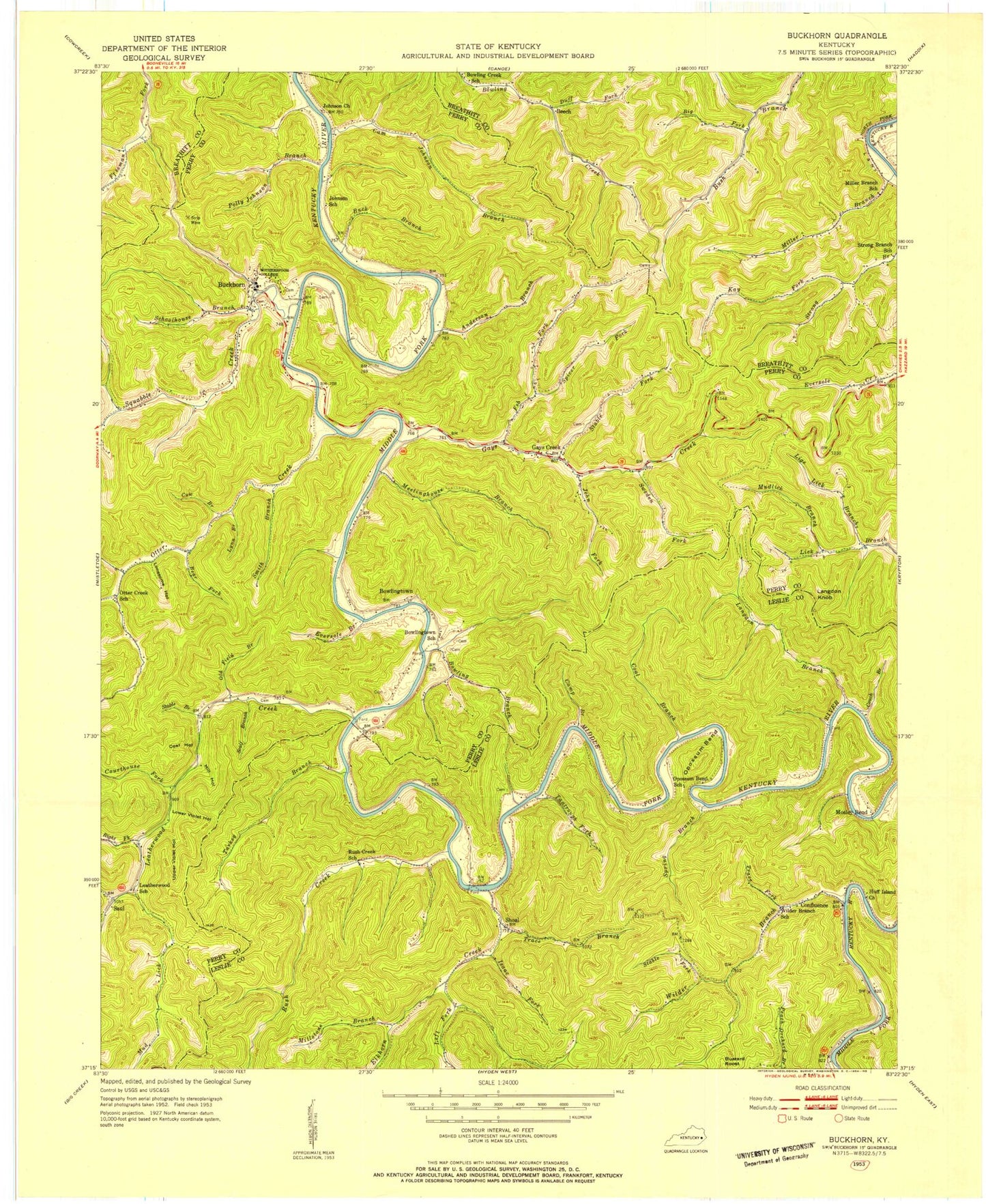
Classic USGS Buckhorn Kentucky 7.5'x7.5' Topo Map
Couldn't load pickup availability
Historical USGS topographic quad map of Buckhorn in the state of Kentucky. Map scale may vary for some years, but is generally around 1:24,000. Print size is approximately 24" x 27"
This quadrangle is in the following counties: Breathitt, Leslie, Perry.
The map contains contour lines, roads, rivers, towns, and lakes. Printed on high-quality waterproof paper with UV fade-resistant inks, and shipped rolled.
Contains the following named places: Abner Fork, Aims Cemetery, Anderson Branch, Bear Fork, Beech, Big Fork, Big Hill, Bowling Branch, Bowling Creek School, Bowlingtown, Bowlingtown Post Office, Bowlingtown School, Buck Branch, Buck Fork, Buckhorn, Buckhorn Dam, Buckhorn Division, Buckhorn Lake, Buckhorn Lake State Resort Park, Buckhorn Post Office, Buckhorn Presbyterian Church, Buckhorn Volunteer Fire Department, Cam Johnson Branch, Camp Branch, City of Buckhorn, Coal Branch, Coal Hollow, Coneva Railroad Station, Confluence, Confluence Post Office, Couch Branch, Courthouse Fork, Cow Branch, Deaton Cemetery, Duff Fork, Elkhorn Creek, Eversole Branch, Feb Fork, Gay Post Office, Gays Creek, Gays Creek Post Office, Isaac Fork, John Fork, Johnson, Johnson Cemetery, Johnson Church, Kay Fork, Langdon Branch, Langdon Knob, Laurel Point, Leatherwood Boat Ramps, Leatherwood Church, Leatherwood Creek, Leatherwood School, Left Fork Elkhorn Creek, Lige Lick Branch, Lonesome Hollow, Lower Leatherwood, Lower Violet Hollow, Lynn Branch, Mary Breckinridge Memorial Park, Meetinghouse Branch, Mill Hollow, Miller Branch, Miller Branch School, Millstone Branch, Mosley Bend, Mud Lick, Mudlick Branch, Old Field Branch, Opossum Bend, Otter Creek, Otter Creek School, Polly Johnson Branch, Right Fork Leatherwood Creek, Rockhouse Fork, Rush Creek, Saul, Saul Post Office, Scalf Branch, Schoolhouse Branch, Shoal, Shoal Post Office, Shoal School, Smith Branch, Spicer Fork, Spring Branch, Squabble Creek, Stable Branch, Stable Fork, Strong Branch School, Sweden Fork, Tantrough Fork, Trace Branch, Trace Fork, Turkey Branch, Upper Violet Hollow, Wharton Post Office, Wilder Branch, Wilder Branch School, ZIP Codes: 41721, 41745, 41762