MyTopo
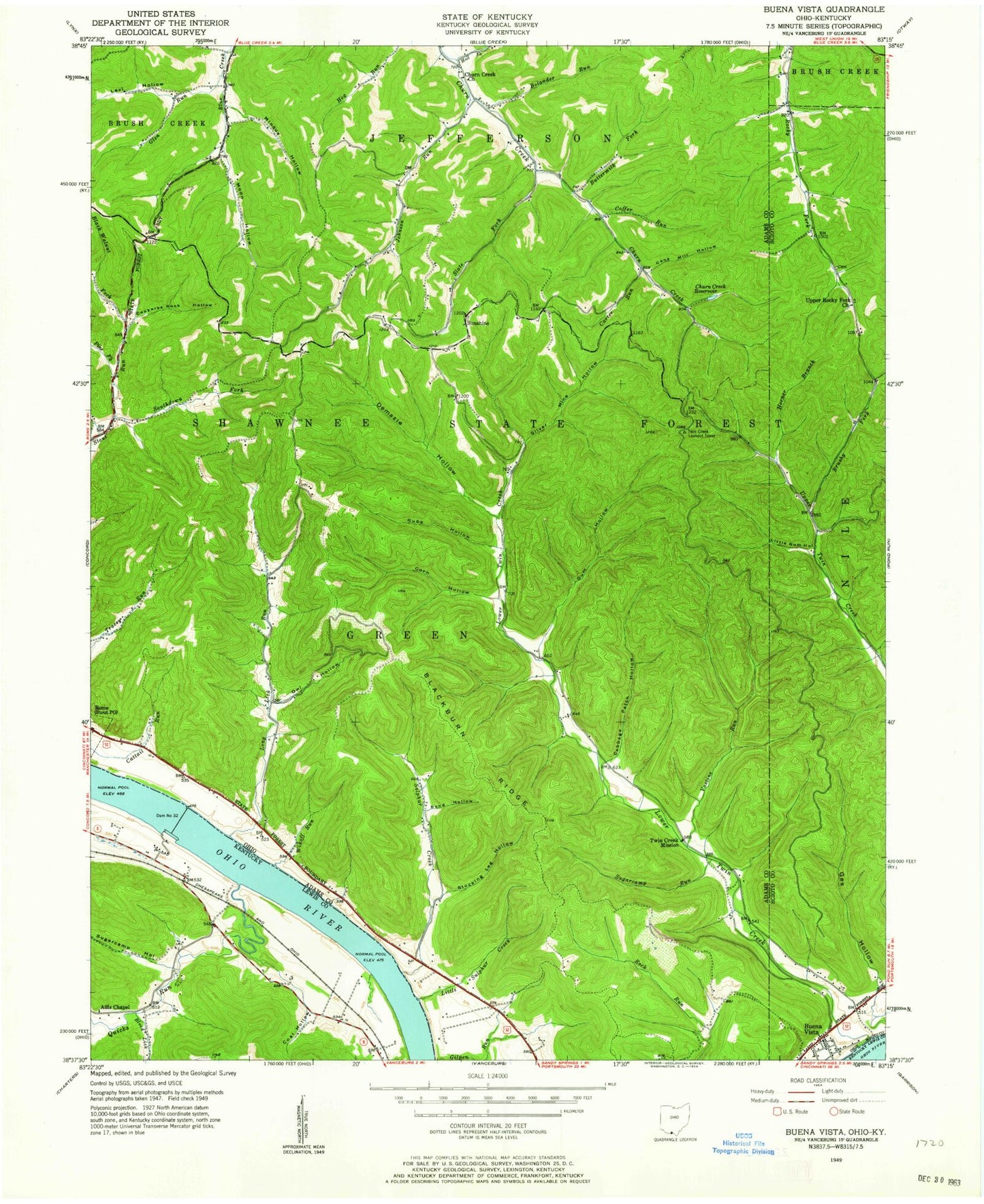
Classic USGS Buena Vista Ohio 7.5'x7.5' Topo Map
Couldn't load pickup availability
Historical USGS topographic quad map of Buena Vista in the states of Ohio, Kentucky. Typical map scale is 1:24,000, but may vary for certain years, if available. Print size: 24" x 27"
This quadrangle is in the following counties: Adams, Lewis, Scioto.
The map contains contour lines, roads, rivers, towns, and lakes. Printed on high-quality waterproof paper with UV fade-resistant inks, and shipped rolled.
Contains the following named places: Black Walnut Fork Stout Creek, Bolander Run, Bond Hollow, Brushy Fork Upper Twin Creek, Buttermilk Fork Churn Creek, Cabbage Patch Hollow, Churn Creek Church, Churn Creek Reservoir, Coffer Run, Copperas Rock Hollow, Corn Hollow, Demazie Hollow, Gas Hollow, Glen Run, Gum Hollow, Hall Fork, High Hill Cemetery, Horner Branch Upper Twin Creek, Johnson Run, Little Gum Hollow, Lower Twin Creek, Manchester Cemetery, Minque Hollow, Moon Hollow, Owl Hollow, Rube Hollow, Slate Fork Churn Creek, Southdown Fork Stout Run, Step Church Cemetery, Stocking Leg Hollow, Sugarcamp Run, Upper Blue Creek Tabernacle, Upper Rocky Fork Church, Vastine Run, Wikoff Run, Brushy Fork School (historical), Twin Creek Bar, Blue Creek School (historical), Bradfords Landing, Fosters Landing, High Hill School (historical), Johnson Run School (historical), Lock and Dam Number 32 (historical), Long Lick School (historical), Lower Churn Creek School (historical), Lower Twin Creek School (historical), Needmore School (historical), Selig, Shamrock Landing, Sulphur Lick School (historical), Twin Creek Mission (historical), Wyckoffs Landing, Wyckoffs Run, Silver Mine Hollow, Shawnee State Wilderness, Buena Vista, Sunshine, Forsythes Landing, Carter Run, Long Lick Run, Pine Fork, Little Sulphur Creek, Sulphur Creek, Minque Run, Moon Run, Twin Creek Lookout Tower, Blackburn Ridge, Township of Green, Step Church, Sunshine Ridge Cemetery, Buena Vista Post Office (historical), Nile Township Volunteer Fire Department Station 2, Blood Lick, Coal Hollow, Quicks Run, Sugarcamp Hollow, Aills Chapel Church, Grahams Railroad Station (historical), Halbert Post Office (historical), Kimballs Landing (historical), Meldahls Landing (historical), Moores Landing (historical), Stone Chimney Landing, Swearingens Landing (historical), Williams Landing (historical), Dam Number 32, Black Walnut Fork Stout Creek, Bolander Run, Bond Hollow, Brushy Fork Upper Twin Creek, Buttermilk Fork Churn Creek, Cabbage Patch Hollow, Churn Creek Church, Churn Creek Reservoir, Coffer Run, Copperas Rock Hollow, Corn Hollow, Demazie Hollow, Gas Hollow, Glen Run, Gum Hollow, Hall Fork, High Hill Cemetery, Horner Branch Upper Twin Creek, Johnson Run, Little Gum Hollow, Lower Twin Creek, Manchester Cemetery, Minque Hollow, Moon Hollow, Owl Hollow, Rube Hollow, Slate Fork Churn Creek, Southdown Fork Stout Run, Step Church Cemetery, Stocking Leg Hollow, Sugarcamp Run, Upper Blue Creek Tabernacle, Upper Rocky Fork Church, Vastine Run, Wikoff Run, Brushy Fork School (historical), Twin Creek Bar, Blue Creek School (historical), Bradfords Landing, Fosters Landing, High Hill School (historical), Johnson Run School (historical), Lock and Dam Number 32 (historical), Long Lick School (historical), Lower Churn Creek School (historical), Lower Twin Creek School (historical), Needmore School (historical), Selig, Shamrock Landing, Sulphur Lick School (historical), Twin Creek Mission (historical), Wyckoffs Landing, Wyckoffs Run, Silver Mine Hollow, Shawnee State Wilderness, Buena Vista, Sunshine, Forsythes Landing, Carter Run, Long Lick Run, Pine Fork, Little Sulphur Creek, Sulphur Creek, Minque Run, Moon Run, Twin Creek Lookout Tower, Blackburn Ridge, Township of Green, Step Church, Sunshine Ridge Cemetery, Buena Vista Post Office (historical), Nile Township Volunteer Fire Department Station 2, Blood Lick, Coal Hollow, Quicks Run, Sugarcamp Hollow, Aills Chapel Church, Grahams Railroad Station (historical), Halbert Post Office (historical), Kimballs Landing (historical), Meldahls Landing (historical), Moores Landing (historical), Stone Chimney Landing, Swearingens Landing (historical), Williams Landing (historical), Dam Number 32