MyTopo
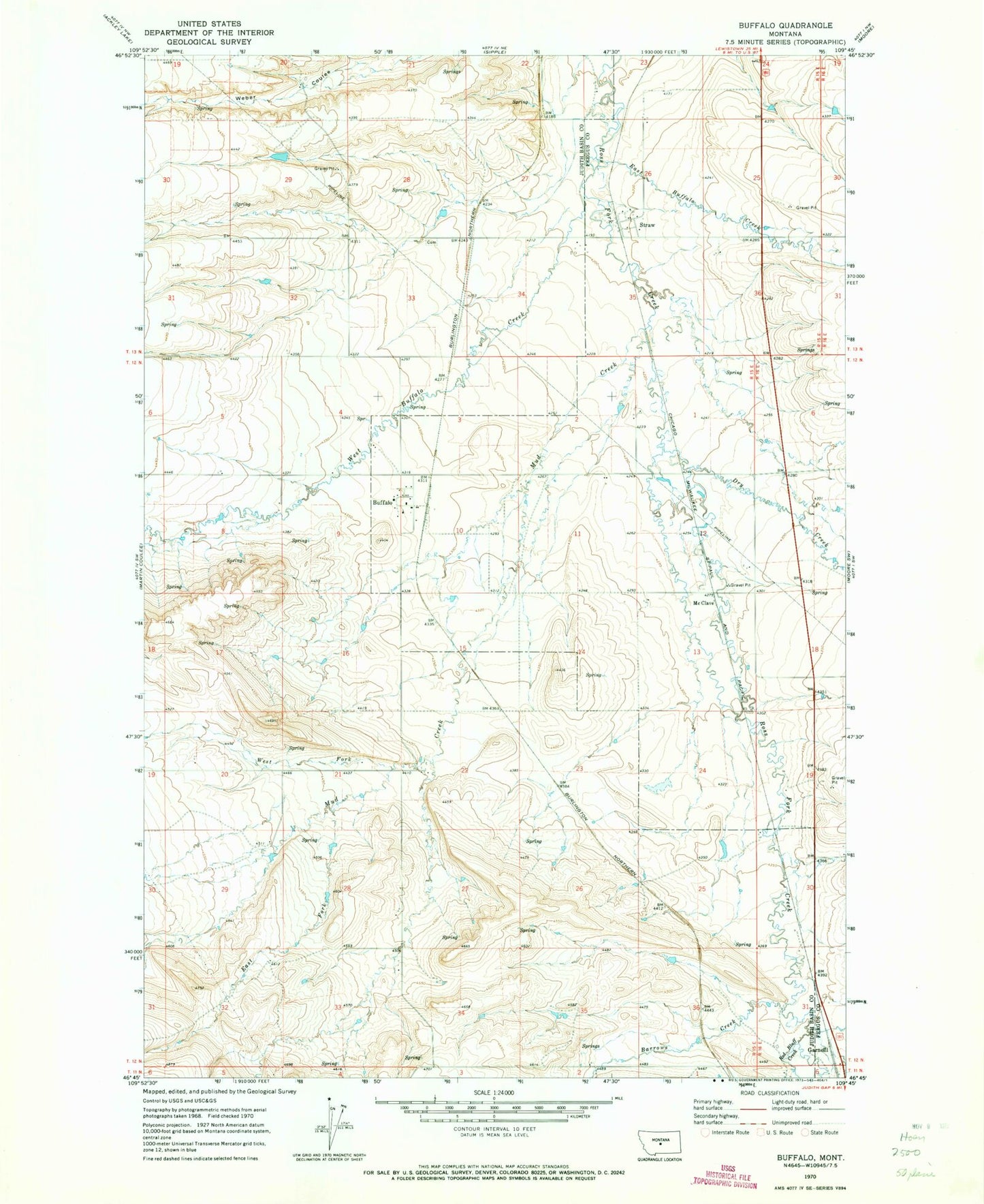
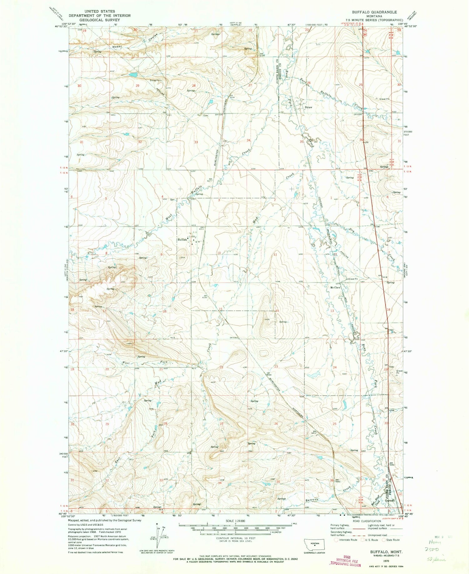
Classic USGS Buffalo Montana 7.5'x7.5' Topo Map
Couldn't load pickup availability
Historical USGS topographic quad map of Buffalo in the state of Montana. Map scale may vary for some years, but is generally around 1:24,000. Print size is approximately 24" x 27"
This quadrangle is in the following counties: Fergus, Judith Basin.
The map contains contour lines, roads, rivers, towns, and lakes. Printed on high-quality waterproof paper with UV fade-resistant inks, and shipped rolled.
Contains the following named places: 11N15E05AA__01 Spring, 11N16E06BB__01 Well, 11N16E06BB__02 Well, 12N15E01BC__01 Well, 12N15E01BC__02 Well, 12N15E04CD__01 Well, 12N15E04CD__02 Well, 12N15E04DC__01 Well, 12N15E04DD__01 Well, 12N15E04DD__02 Well, 12N15E04DD__03 Well, 12N15E04DD__04 Well, 12N15E04DD__05 Well, 12N15E05CD__01 Well, 12N15E08AA__01 Well, 12N15E08AA__02 Well, 12N15E08AD__01 Well, 12N15E08AD__02 Well, 12N15E09AA__01 Well, 12N15E09AA__02 Well, 12N15E10AA__01 Well, 12N15E10AA__02 Well, 12N15E10AA__03 Well, 12N15E10BB__01 Well, 12N15E10BB__02 Well, 12N15E10BB__03 Well, 12N15E10BC__01 Well, 12N15E10BC__02 Well, 12N15E11AA__01 Well, 12N15E11AA__02 Well, 12N15E12DD__01 Well, 12N15E12DD__02 Well, 12N15E13BB__01 Well, 12N15E20AC__01 Spring, 12N15E20BC__01 Well, 12N15E20BC__02 Well, 12N15E20BC__03 Spring, 12N15E21AC__01 Well, 12N15E21AC__02 Well, 12N15E22BC__01 Well, 12N15E22BC__02 Well, 12N15E22BCDC01 Well, 12N15E22BD__02 Well, 12N15E22BD__03 Well, 12N15E22CB__01 Well, 12N15E25AA__01 Well, 12N15E28DA__01 Well, 12N15E29AA__01 Well, 12N15E29AD__01 Spring, 12N15E29DD__01 Well, 12N15E33AA__01 Well, 12N15E33AA__02 Well, 12N15E33BB__01 Well, 12N15E34AA__01 Well, 12N15E34BD__01 Well, 12N15E35DC__01 Well, 12N16E07BB__01 Well, 12N16E19CD__01 Well, 12N16E19CD__02 Well, 12N16E30AB__01 Well, 12N16E30BB__01 Well, 12N16E30BB__02 Well, 12N16E30BB__03 Well, 12N16E30DCC_01 Well, 12N16E31AC__01 Well, 12N16E31CC__01 Well, 12N16E31CC__02 Well, 12N16E31CD__01 Well, 12N16E31DC__01 Well, 13N15E22DC__01 Spring, 13N15E23CC__01 Well, 13N15E23DB__01 Well, 13N15E25CC__01 Well, 13N15E26AB__01 Well, 13N15E26CC__01 Well, 13N15E26CD__01 Well, 13N15E26CD__02 Well, 13N15E26CD__03 Well, 13N15E26CD__04 Well, 13N15E26CD__05 Well, 13N15E31BD__01 Spring, 13N15E32AD__01 Well, 13N15E34AA__01 Well, 13N15E34AA__02 Well, 13N15E34AA__03 Well, 13N15E35BB__01 Well, 13N15E35BB__02 Well, 13N15E36BB__01 Well, 13N15E36BB__02 Well, Barrows, Barrows Creek, Buffalo, Buffalo Cemetery, Buffalo Community Church, Buffalo Creek, Buffalo Post Office, Buffalo School, Bye-Bye Dam, Dry Creek, East Fork Mud Creek, Farmers Elevator, Garneill, Garneill Cemetery, Garneill Elevator, Garneill Post Office, McCall-Webster Elevator, McClave, Meadow Creek, Monk Coulee, Montana Elevator, Mud Creek, Red Bluff Creek, Rocky, Straw, Straw Post Office, West Buffalo Creek, West Fork Mud Creek