MyTopo
Classic USGS Burnt Hickory Ridge Georgia 7.5'x7.5' Topo Map
Couldn't load pickup availability
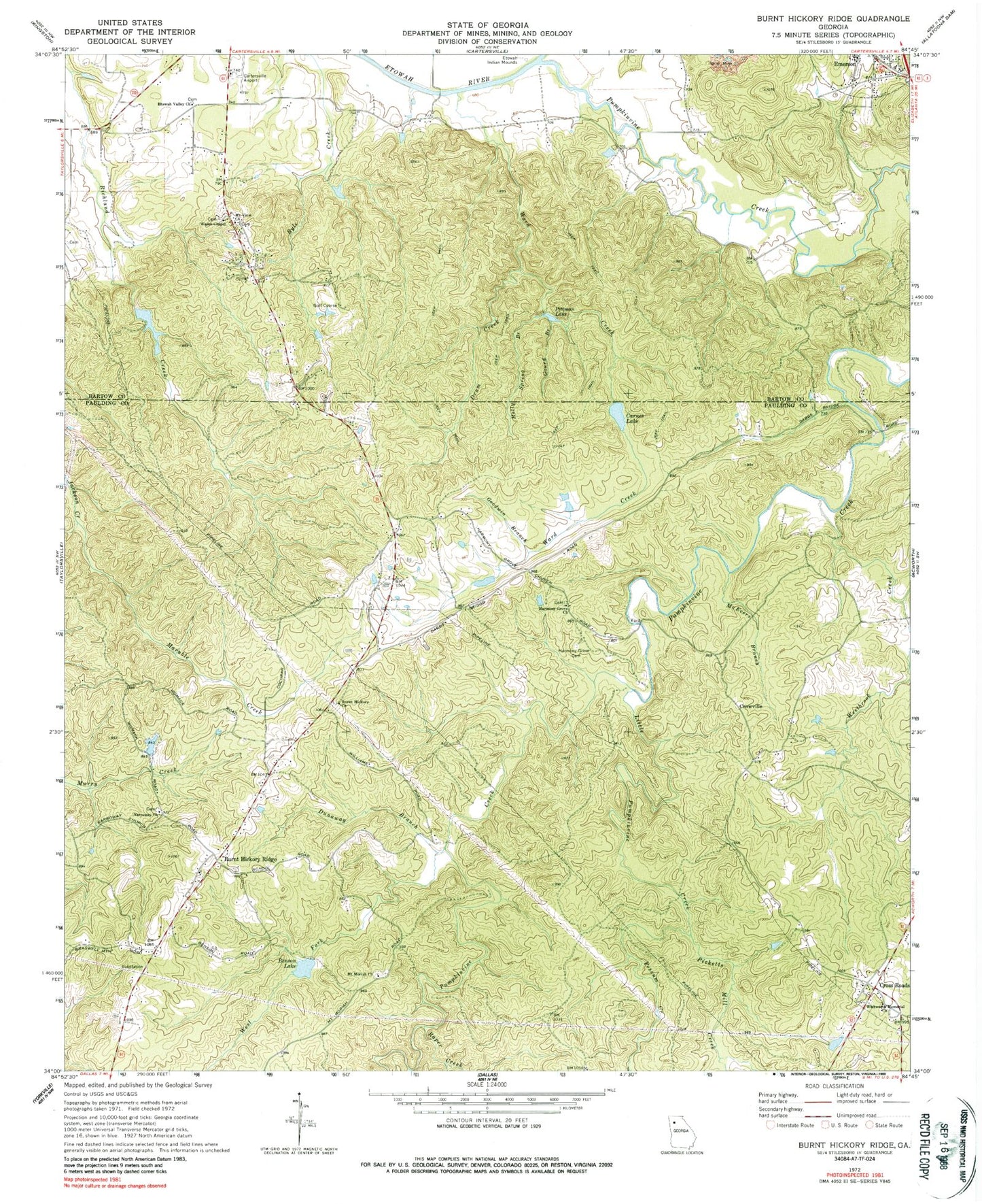
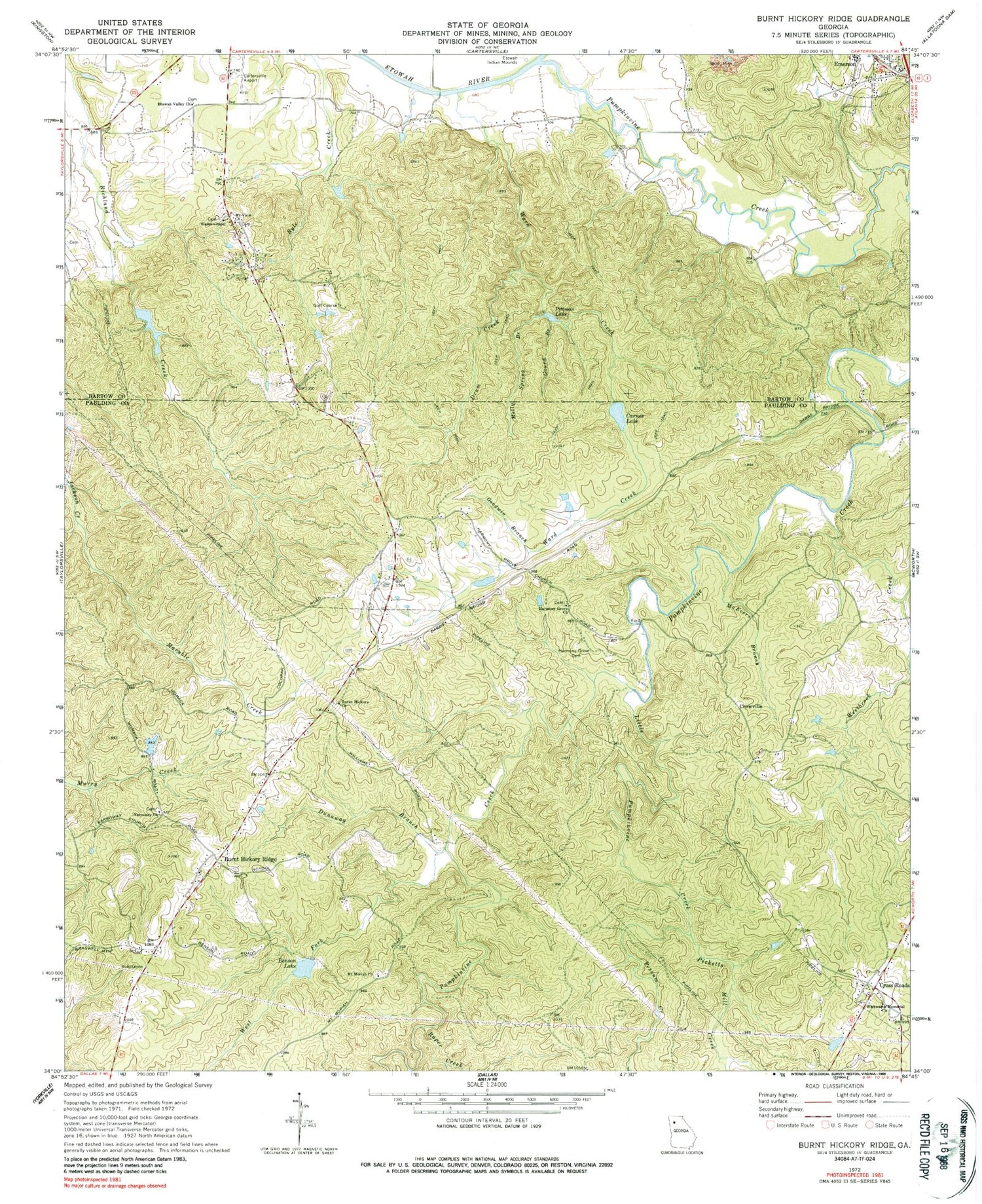
Historical USGS topographic quad map of Burnt Hickory Ridge in the state of Georgia. Map scale is 1:24000. Print size is approximately 24" x 27"
This quadrangle is in the following counties: Bartow, Paulding.
The map contains contour lines, roads, rivers, towns, and lakes. Printed on high-quality waterproof paper with UV fade-resistant inks, and shipped rolled.
Contains the following named places: Bartow County Fire Department Station 9, Benson Lake, Browns Lake, Burnt Hickory Church, Burnt Hickory Elementary school, Burnt Hickory Farms, Burnt Hickory Ridge, Burnt Hickory Ridge Estates, Carnes Lake, Cartersville Airport, Cedar Ridge, Conner Lake, Cross Road Farms, Cross Roads, Cross Roads Cemetery, Cross Roads Church, Crossroads United Methodist Church, Crowville, Dellinger Lake, Dellinger Lake Dam, Douthit Family Cemetery, Drum Creek, Dunaway Branch, Dunaway Mine, Emerson City Cemetery, Emerson Elementary School, Etowah Valley Baptist Church Cemetery, Etowah Valley Church, George H McMillan Bridge, Goodwin Branch, Gourd Branch, Harmony Grove Cemetery, Harmony Grove Church, Hodges Prospect, Holly Spring Branch, Indian Valley, Little Pumpkinvine Creek, Lucas Family Cemetery, Marable Creek, McEvers Branch, Merritt Mine, Mount Moriah Cemetery, Mount Moriah Church, Mount View Church, Mountain Ridge Estates, Mountain View Church of God Cemetery, Narroway Cemetery, Narroway Church, North Paulding Division, North Paulding High School, Oak Hill, Parkerosa, Pathway Church, Paulding County Fire and Rescue Bureau Station 6, Paulding County Fire and Rescue Bureau Station 8, Picketts Creek, Picketts Mill Creek, Pittman Lake, Possum Creek, Pumpkinvine Creek, Pumpkinvine Creek Structure Number 16 Dam, Pumpkinvine Creek Structure Number One Dam, Pumpkinvine Creek Structure Number Two Dam, Racoon Creek Structure Number Eight Dam, Racoon Creek Structure Number Seven Dam, Raper Creek, Royal Oaks Golf Course, Russell Mine, Sammy McClure Middle School, Sheffield-Heidt Prospect, Shelton Elementary School, South Central Middle School, Taylor Lake, Taylor Lake Dam, Twilley Mine, Valley Oak Acres, Wade Chapel Holiness Church Cemetery, Wades Chapel, Ward Creek, West Fork Pumpkinvine Creek, Westbrook Creek, Westfork, Whitworth Memorial Church, Woodland High School