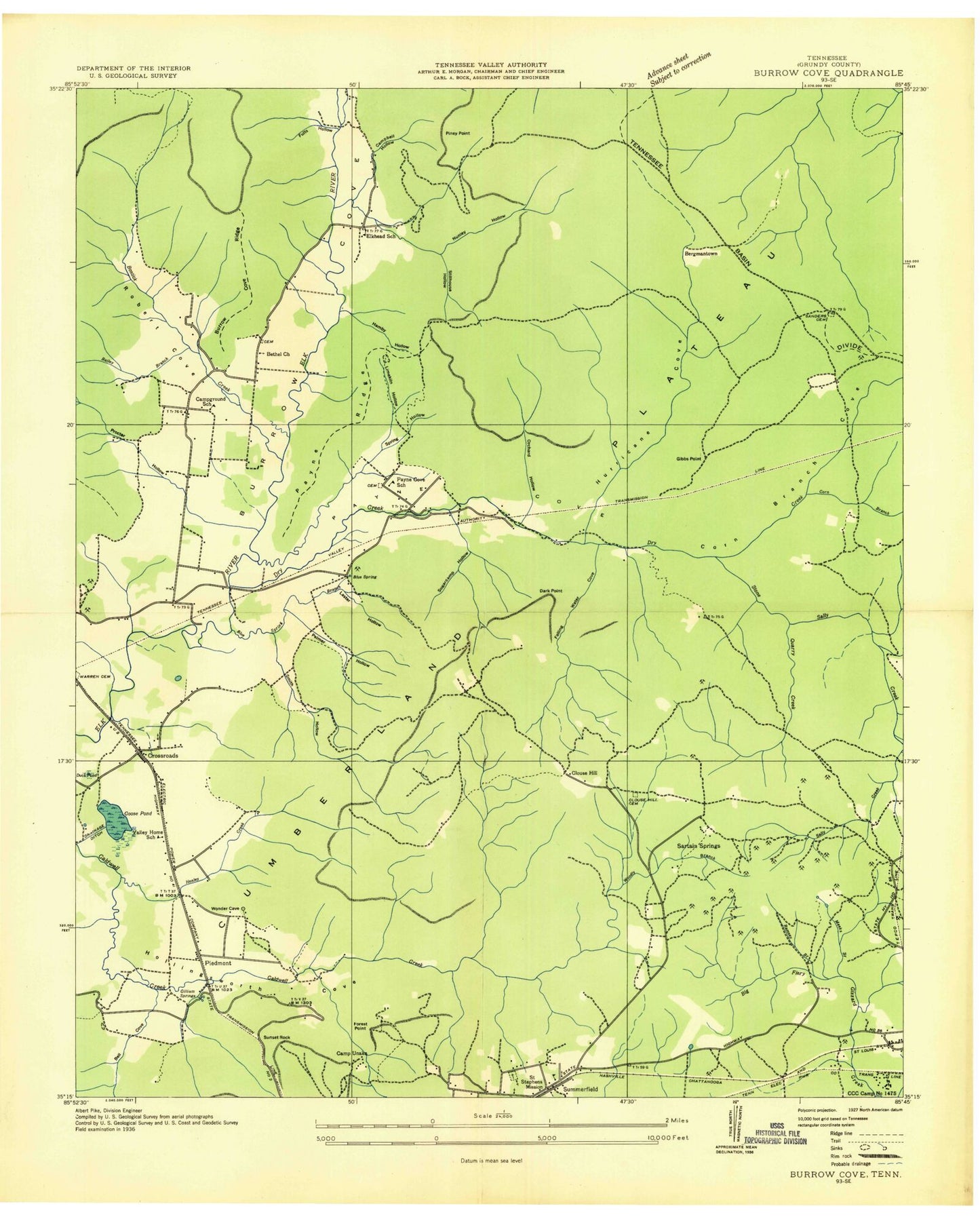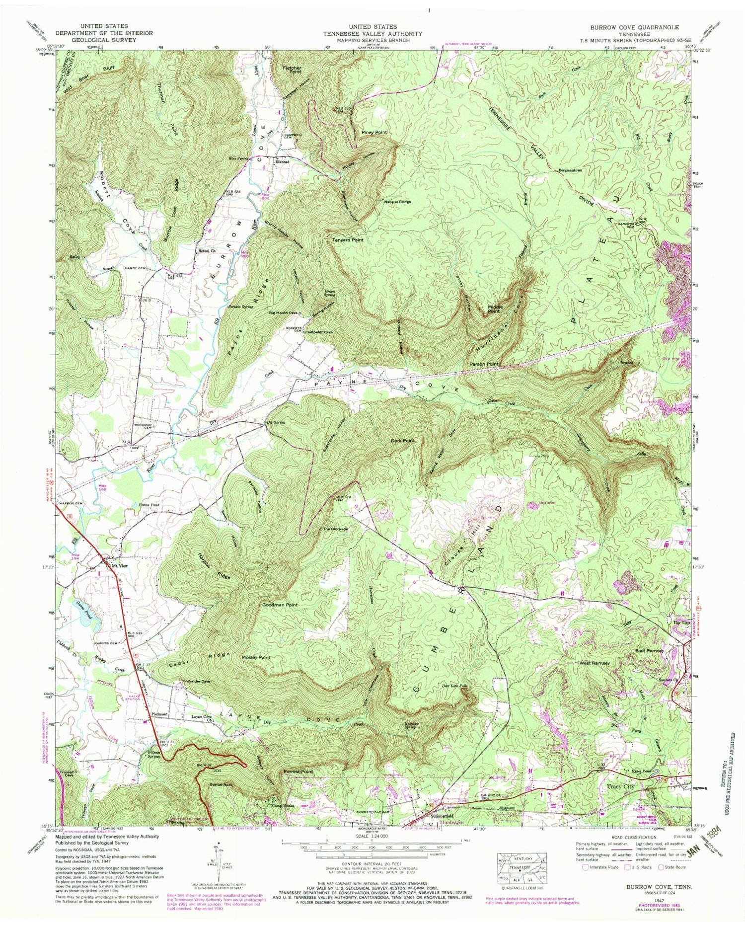

MyTopo
Classic USGS Burrow Cove Tennessee 7.5'x7.5' Topo Map
Couldn't load pickup availability
Historical USGS topographic quad map of Burrow Cove in the state of Tennessee. Typical map scale is 1:24,000, but may vary for certain years, if available. Print size: 24" x 27"
This quadrangle is in the following counties: Coffee, Grundy.
The map contains contour lines, roads, rivers, towns, and lakes. Printed on high-quality waterproof paper with UV fade-resistant inks, and shipped rolled.
Contains the following named places: Eagle Cliff, Smith Hollow, Spring Hollow, Stillhouse Hollow, Sugarcamp Hollow, Summerfield, Summerfield Cemetery, Tanyard Point, The Blockade, The Hurricane, Thurman Point, Tip Top, Trussell Creek, Valley Home School, West Ramsey, Bailey Branch, Bethel Church, Blue Spring, Bostick Creek, Burrow Cove Ridge, Camp Unaka, Campbell Cemetery, Campbell Hollow, Cedar Ridge, Clouse Hill, Clouse Hill School, Corn Branch, Deer Lick Falls, Dry Creek, Dry Creek, Duck Point, Duck Pond, East Ramsey, Elkhead School, Falling Water Cove, Flatrock Branch, Fletcher Point, Forrest Point, Gilliam Creek, Gilliam Springs, Goodman Cemetery, Goodman Point, Goose Pond, Granny Hamby Hollow, Gravel Spring, Hamby Cemetery, Hargiss Cemetery, Hargiss Ridge, Henley Creek, Hines Pond, Hurricane Cove, Hurricane Creek, Joy Creek, Laurel Creek, Layne Cove, Layne Cove Church, Limekiln Hollow, Little Fiery Gizzard Creek, Maple Branch, Meeks Branch, Middle Point, Milksick Hollow, Mosley Point, Mount View, Nunley Hollow, Orchard Hollow, Parmley Hollow, Parson Point, Patton Pond, Payne Cove School, Payne Ridge, Piney Hollow, Piney Point, Procter Hollow, Rainbow Spring, Ramsey Branch, Robert Cove, Roberts Cemetery, Sally Creek, Sanders Cemetery, Sanders Church, Sanders School, Sartain Spring, Highlander Pond, Highlander Pond Dam, Littell Number One Lake, Littell Number One Lake Dam, Plainview Lake, Plainview Dam, Stonequarry Creek, Sunset Rock, Trussell Cove, Warren Cemetery, Big Spring, Burrow Cove, Campground School, Blue Spring Branch, Broad Mountain, Civilian Conservation Corps Camp Number 1455 (historical), Clouse Hill, Clouse Hill Cemetery, Corn Branch Cove, Elk Bridge, Fults Hollow, Grundy Forest State Natural Area, Laster Hollow, Payne Cove, Saint Stephens Mission (historical), Sartain Springs, Woodly Branch, Valley Home, Bergmantown, Piedmont, Bethel Cemetery, Bethel Cemetery, Big Spring Cemetery, Paynes Cove Cemetery, Paynes Cove Methodist Church, Clouse Hill Mines, Shetter Quarry, Summerfield School (historical), Patrick Cemetery, Payne Cove, Pelham Division (historical), Elkhead, Town of Tracy City, Commissioner District 3, Pelham Census Designated Place, Pelham Valley Volunteer Fire Department, Krashinsky Airfield