MyTopo
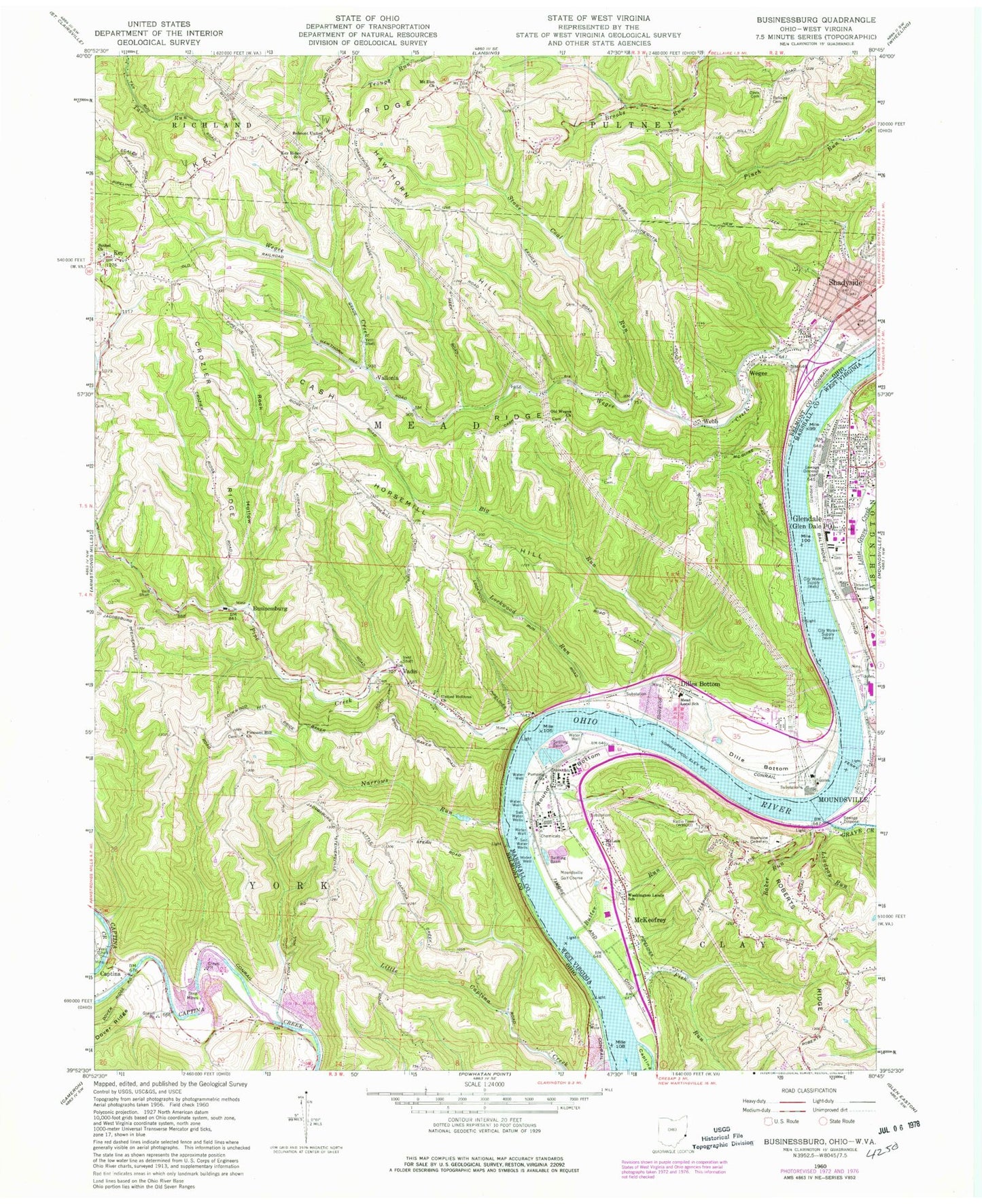
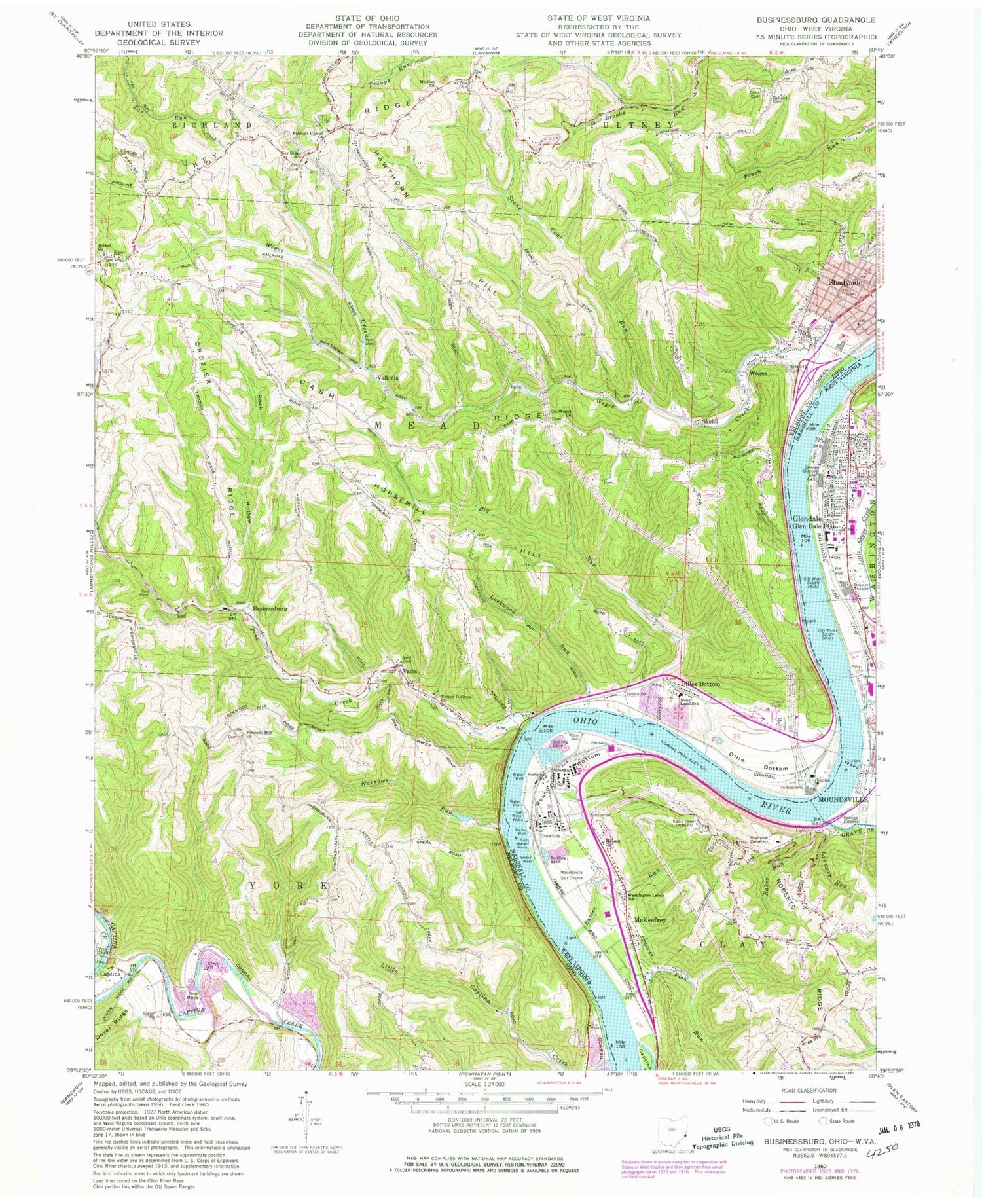
Classic USGS Businessburg Ohio 7.5'x7.5' Topo Map
Couldn't load pickup availability
Historical USGS topographic quad map of Businessburg in the states of Ohio, West Virginia. Map scale may vary for some years, but is generally around 1:24,000. Print size is approximately 24" x 27"
This quadrangle is in the following counties: Belmont, Marshall.
The map contains contour lines, roads, rivers, towns, and lakes. Printed on high-quality waterproof paper with UV fade-resistant inks, and shipped rolled.
Contains the following named places: Alexander Mine, Anvil, Anvil Post Office, Arch A Moore Bridge, B M Spurr School of Practical Nursing, Baker Run, Bellaire Cemetery, Belmont Cemetery, Belmont United Church, Bethel Christian Fellowship Church, Bethel Church, Big Run, Businessburg, Businessburg Post Office, Butter Run, Captina, Captina Island, Captina Post Office, Cash Ridge, Christ United Methodist Church, Church of Christ, City of Glen Dale, Crozier Ridge, Davis Cemetery, Dille Bottom, Dille Station, Dilles Bottom, Dilles Bottom Pot Office, Dowdell Park, Dunfee, Dunfee Cemetery, Eugene Fitzwater Spring, Fish Run, Glen Dale Drive-In, Glen Dale Elementary School, Glen Dale Police Department, Glen Dale Post Office, Glen Dale United Methodist Church, Glen Dale Volunteer Fire Department Station 1, Glen Dale Volunteer Fire Department Station 2, Glendale, Glendale City Hall, Glendale Fokker Field, Glendale Public School, Grave Creek, Haven On The Ohio Park, Hawthorn Hill, Heath, Heath Post Office, Hog Run Post Light, Horsemill Hill, Hughes Memorial Chapel, John Marshall Adult Preparatory School, John Marshall High School, Key, Key Cemetery, Key Post Office, Key Ridge, Key Ridge Elementary School, Lindsay Run, Little Captina Creek, Little Grave Creek, Little Grave Creek Bar, Lockwood Cemetery, Lockwood Run, Lower Wegee Cemetery, Maloneys Mobile Home Park, McKeefrey, McKeefrey School, McLain Church, Mead Elementary School, Moundsville Boat Club, Moundsville Bridge, Moundsville Country Club Golf Course, Moundsville Plaza Shopping Center, Moundsville Seaplane Base, Mount Zion Cemetery, Narrows Run, North Lafayette Shopping Center, Old Wegee Church, Pentecostal Mission, Pipe Creek, Pleasant Hill Cemetery, Pleasant Hill Church, Praise Christian Academy, Praise Fellowship Church, R E Burger Power Plant, Reynolds Memorial Hospital, Riggs School, Riverside Park, Riverview Cemetery, Rock Hollow, Round Bottom, Round Bottom School, Saint Jude Catholic Church, Shadyside, Shadyside Fire Department Station 35, Spirit of 76 Volunteer Fire Department, Stone Coal Run, Township of Mead, Township of York, United Holiness Church, Upper Wegee Cemetery, Vadis, Vadis Post Office, Vallonia, Vallonia Area Cemetery, Vallonia Post Office, Village of Shadyside, Washington Lands Elementary School, Washington Lands Volunteer Fire Department, Webb, Wegee, Wegee Creek, Wegee Post Office, WEIF-AM (Moundsville), West Virginia State Police Troop 1 - Moundsville Detachment, Workman Cemetery, Zitko Terrace, ZIP Code: 43947