
MyTopo
Classic USGS Butte North Montana 7.5'x7.5' Topo Map
Couldn't load pickup availability
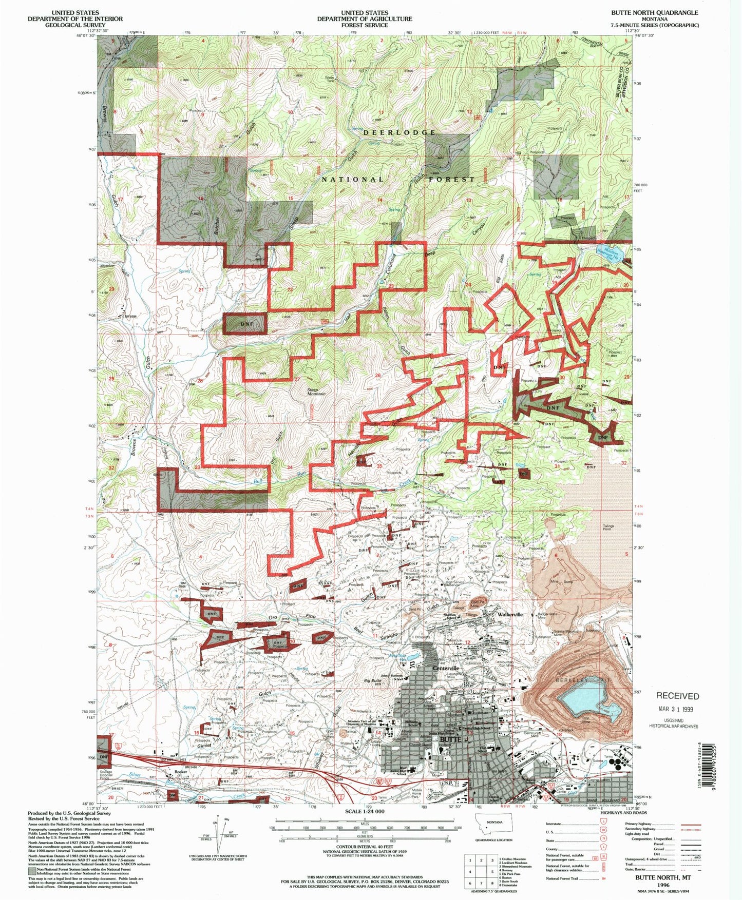
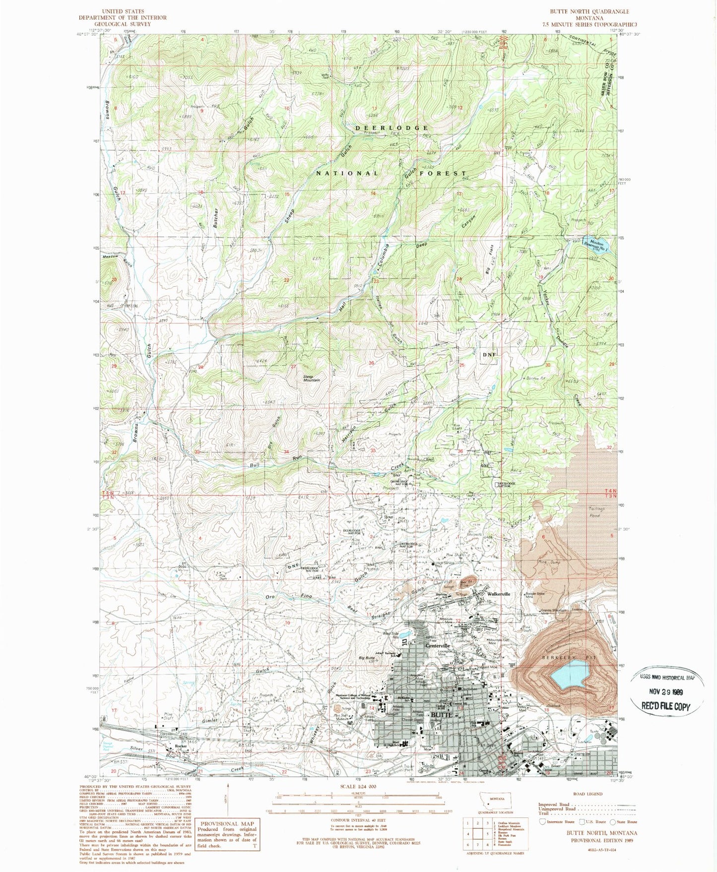
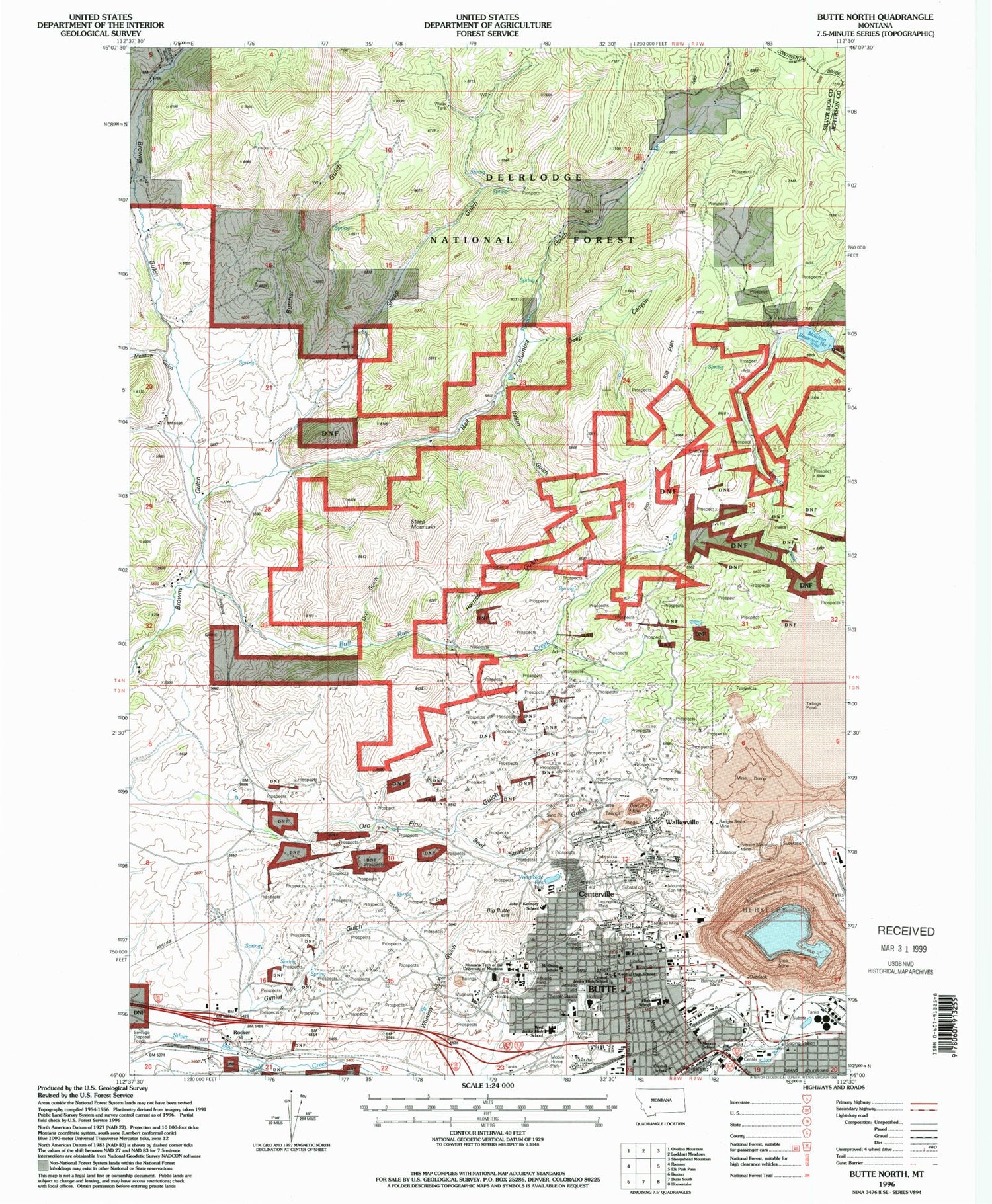
Historical USGS topographic quad map of Butte North in the state of Montana. Map scale is 1:24000. Print size is approximately 24" x 27"
This quadrangle is in the following counties: Jefferson, Silver Bow.
The map contains contour lines, roads, rivers, towns, and lakes. Printed on high-quality waterproof paper with UV fade-resistant inks, and shipped rolled.
Contains the following named places: 1706 North Main Street Mine, 21 East Gagnon Street Mine, 400 West Porphyry Street Mine, 401 West Boardman Mine, 43 West La Plata Street Mine, 937 Sutter Street Mine, AA Westside Mobile Estates, Abundant Life Fellowship Church, Advanced Dermatology of Butte, Advanced Pediatrics, Alice Pit, Allendale (historical), Anderson Post Office (historical), Anderson Spur (historical), Anselmo (historical), Anselmo Air Shaft, Anselmo Mine, Anselmo Mine, Anselmo Sand Pass Mine, Antonioli Mine, Artic Mine, Arts Chateau, Associated Missoula Podiatry, Badger State Mine, Badlands, Baker Spring, Beer Straight Gulch, Belle of Butte Mine, Belmont Mine, Belmont Mine, Benham Mine, Berkeley Pit, Berkeley Pit Information Center, Berkeley Pit Viewing Stand, Big Butte, Big Flats, Blaine School Mine, Blue Bird (historical), Bonanza Air Shaft, Bradley Spring, Britania Number 1 Mine, Bull Run Creek, Burlington (historical), Burlington Post Office (historical), Burlington School (historical), Butcher Gulch, Butchertown (historical), Butte, Butte - Silver Bow County Sheriff's Office, Butte - Silver Bow Courthouse, Butte - Silver Bow Fire Department Station 1, Butte Central High School, Butte Church of God-Cleveland Tennessee Affiliates, Butte High School, Butte Hill (historical), Butte Orthopedic Fracture Clinic, Butte Police Department, Butte Radiology Associates, Butte Rescue Mission, Butte Unity Truth Church, Canada Creek, Carpenter Ranch, Centerville, Central Junior High School, Central School, Chester Steele Park, Church of God of Prophecy, Clear Grit Mine, Colorado Mine, Congregation B'Nai Israel, Copper King National Mansion Historic Place, Corra Mine, Davis-Daly Shaft, Deep Canyon, Deerlodge Supervisors Office, Diamond Mine, Dry Gulch, East Gray Rock Mine, East Little Mina Mine, Elba Number 1 and 2 Mine, Ellingswood Mine, Emma Mine, Emma Park, Emma Waste Dump Mine, Evangelical Covenant Church, Eveline Mine, First Baptist Church, First Christian Church, First Christian Church, First Church of Christ Scientist, First Presbyterian Church, Flume Gulch, Gagnon Coal Spur (historical), Gagnon Mine, Gagnon Ore Spur (historical), Garibaldi Mine, Germania Numbers 1 2 3 Mine, Gimlet Gulch, Glengarry Mine, Gold Hill Lutheran Church, Goldsmith, Goldsmith Mine, Grace Bible Baptist Church, Granite Mountain Memorial, Granite Mountain Mine, Great Republic Mine, Greeley Elementary School, Green Copper Mine, Green Mountain Mine, Hail Columbia Gulch, Hamblin Heights Mobile Village, Harrison Gulch, Heany Mine, Hebgen Childrens Park, High Service Reservoir, Humbolt Mine, Immaculate Conception Church, Italian Gulch, Jacobs House Uptown Visitor Center, Josephine Flag Mine, Kennedy School, KJLF-FM (Butte), KMSM-FM (Butte), Last Chance/Tiger Mine, Lexington Mine, Lexington Mine, Lexington Sand Pass Mine, Lexington Tunnel, Little Mina Mine, Magna Charta Mine, Mary Louise Number 2 Mine, McGruff Park, McKinley School (historical), Meaderville, Meaderville Post Office (historical), Meadow Gulch, Meadow Gulch School (historical), Mercury Street Medical, Minnie Irvine Mine, Minnie Jane Number 1 Mine, Missoula, Missoula Mine, Missoula Mine, Missoula Number 2 Mine, Monroe School (historical), Montana Surgery Center, Montana Tech of the University of Montana, Montana Urology Incorporated, Moose Air Shaft, Moose Auraria Mine, Moulton Distribution Reservoir, Moulton Reservoir Number One, Mountain Con Mine, Mountain Consolidated Number 1 Mine, Mountain Consolidated Number 2 Mine, Mountain View Mine (historical), Mountain View United Methodist Church, NE NW Section 36 Mine, Neurological and Neurosurgical Clinic, New Era/Downey Mine, North Walkerville (historical), Norwich Irving Mine, Old Glory Mine, Ophir Mine, Original Mine, Original Mine, Original Number 6 Mine, Oro Fino Gulch, Orphan Boy Mine, Orphan Girl Mine, Otisco Air Shaft, Otisco Mine, Park Street Baptist Church, Parrott Air Shaft, Paymaster Mine, Pioneer, Plutus, Prospector Mine, Railroad Loop Mine, Rialto Mine, Rising Star Number 1 Mine, Rocker, Rocker (historical), Rocker Post Office (historical), Rocker School (historical), Saint James Healthcare, Saint John's Episcopal Church, Saint Joseph's Catholic Church, Saint Lawrence O'Toole Church, Saint Mark Lutheran Church, Saint Patrick's Catholic Church, Salvation Army Church, SE SW Section 19 Mine, Sheep Gulch, Sherman School (historical), Silver King Mine, Sister Mine, Smokehouse Mine, South Butte Post Office (historical), Southwest Montana Radiology, Star West Mine, Steep Mountain, Steward Mine, Stringtown (historical), Swede Dahlberg Field, Syndicate Pit, Syndicate Shaft, Temple Baptist Church, The Mai Wah, Ticon Mine, Travona Mine, Travona Mine, Trinity United Methodist Church, Tzarena Mine, United Pentecostal Church of Butte, Valdemere Mine, Venus Mine, Wake Up Jim Mine, Walkerville, Walkerville Post Office (historical), Washoe Mine, West Butte (historical), West Elementary School, West Gagnon Mine, West Gray Rock Mine, West Side Reservoir, West Steward Mine, Westside Reservoir Dam, Westside Reservoir Park, Whiskey Gulch, Wild Bill Number 1 Mine, Wild Bill Number 2 Mine, World Museum of Mining, Wyoming Street Shaft, Yankee Doodle Creek, Yankee Doodle Tailings Dam