MyTopo
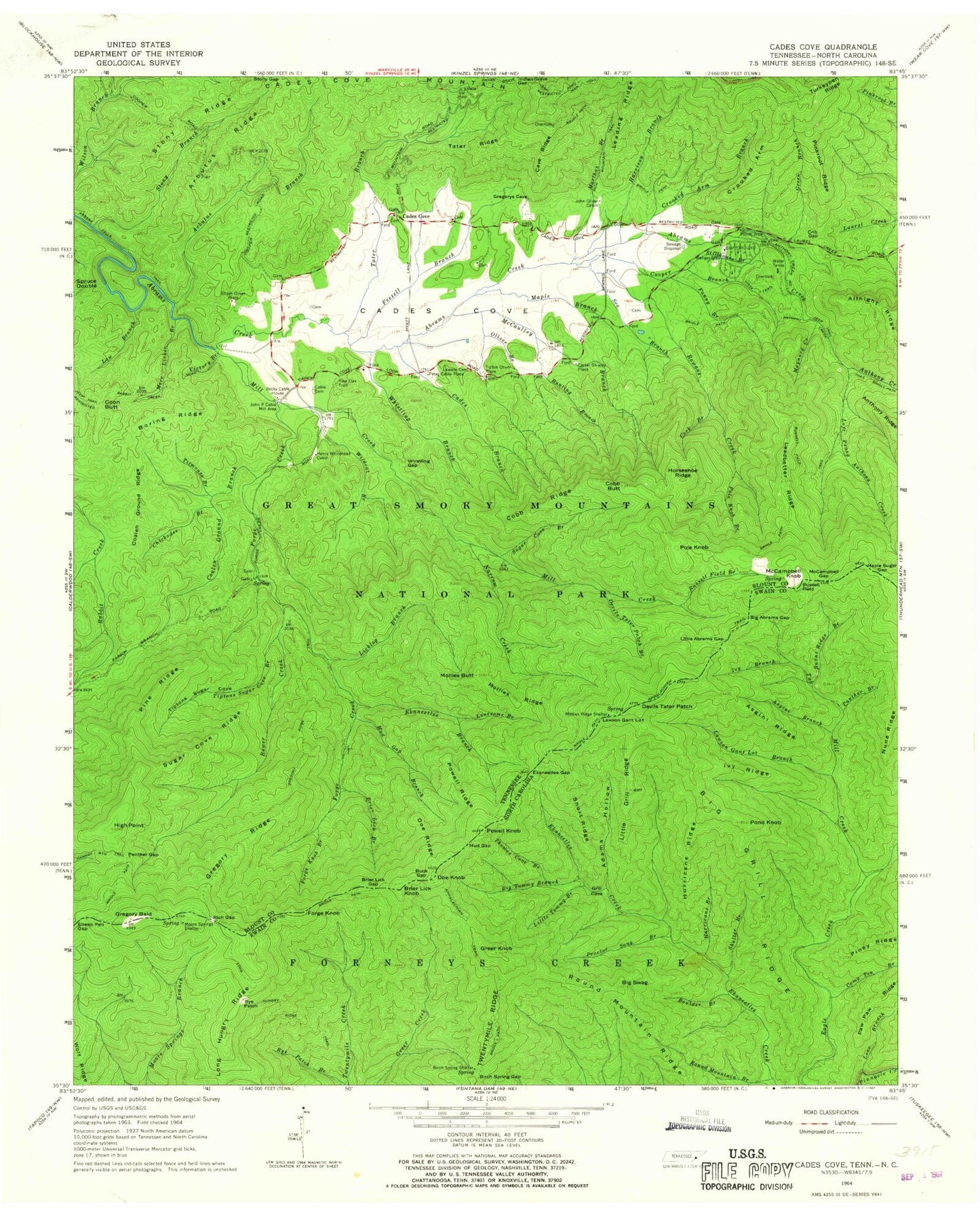
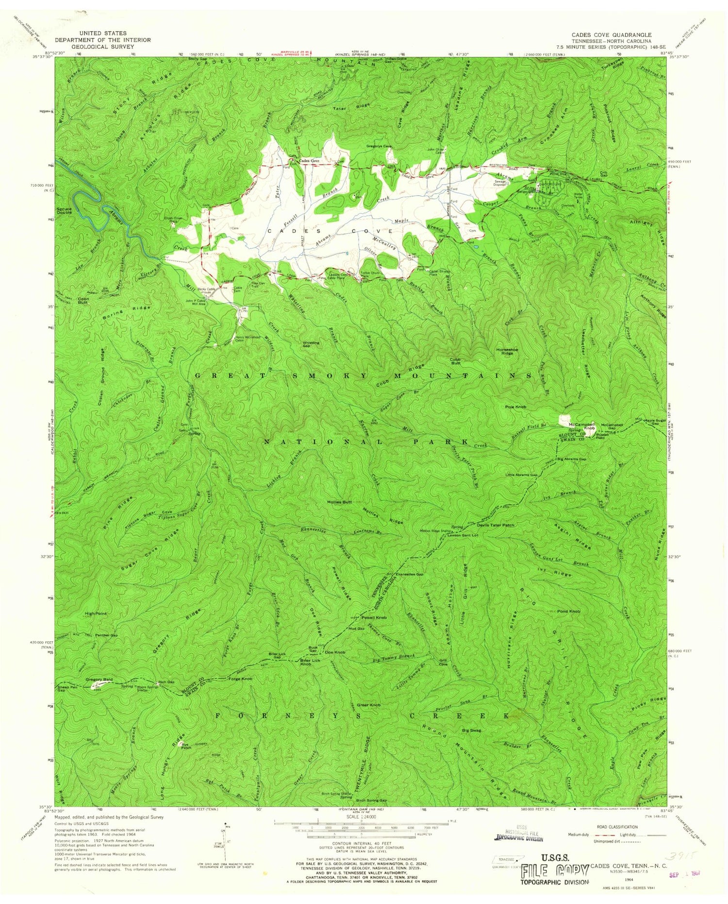
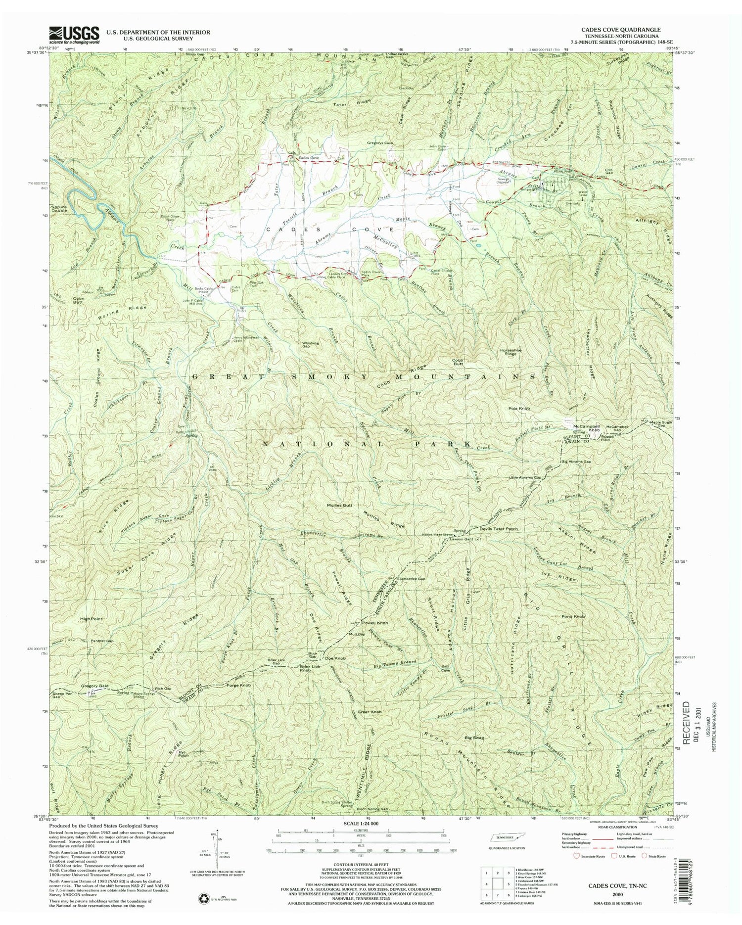
USGS Classic Cades Cove Tennessee 7.5'x7.5' Topo Map
Couldn't load pickup availability
Historical USGS topographic quad map of Cades Covein the states of Tennessee, North Carolina. Scale: 1:24000. Print size: 24" x 27"
This quadrangle is in the following counties: Blount, Swain.
The map contains contour lines, roads, rivers, towns, lakes, and grids including latitude / longitude and UTM / MGRS. Printed on high-quality waterproof paper with UV fade-resistant inks.
Contains the following named places: Big Grill Ridge, Lawson Gant Lot, Little Abrams Gap, Maple Sugar Gap, Mud Gap, Cold Spring Gap, Gregorys Little Bald, Little Bald, Indian Grave Gap, Left Prong Anthony Creek, Sheep Pen Gap, Spruce Double, Stillhouse Branch, Stony Branch, Stony Gap, Sugar Cove Branch, Sugar Cove Ridge, Tater Branch, Tater Ridge, Tiptons Sugar Cove, Tiptons Sugar Cove Branch, Titmouse Branch, Turkeypen Ridge, Victory Branch, Vista Trail, Whistling Branch, Whistling Gap, Wildcat Branch, Abrams Falls Trail, Anthony Creek, Anthony Creek Trail, Arbutus Branch, Arbutus Ridge, Becky Cable House, Big Abrams Gap, Boring Ridge, Bower Creek, Brier Lick Branch, Brier Lick Gap, Brier Lick Knob, Buck Gap, Bunting Branch, Cable Cemetery, Cades Branch, Cades Cove Mountain, Cave Ridge, Chickadee Branch, Coalen Ground Branch, Coalen Ground Ridge, Cobb Butt, Cobb Ridge, Coon Butt, Cork Branch, Crib Gap, Crooked Arm, Crooked Arm Branch, Devils Tater Patch, Devils Tater Patch Branch, Doe Knob, Doe Ridge, Ekaneetlee Branch, Ekaneetlee Gap, Fanny Branch, Feezell Branch, Forge Creek, Forge Knob, Forge Knob Branch, Green Branch, Gregory Bald, Gregory Ridge, Harrison Branch, Henry Whitehead Cabin, High Point, Horseshoe Ridge, John Oliver Cabin, John P Cable Mill Area, Law Branch, Lawson Cemetery, Leadbetter Ridge, Leading Ridge, Licklog Branch, Lonesome Branch, Maple Branch, Marthas Branch, Maynard Creek, McCampbell Gap, McCampbell Knob, McCaulley Branch, Mill Creek, Mollies Butt, Mollies Ridge, Mollies Ridge Shelter, More Licker Branch, Mud Gap Branch, Narrow Creek, Oliver Branch, Panther Gap, Pine Oak Trail, Pine Ridge, Pinkroot Ridge, Pole Knob, Pole Knob Branch, Powell Knob, Powell Ridge, Rich Gap, Rich Mountain Trail, Rowans Creek, Russell Field, Russell Field Branch, Russell Field Trail, Scott Mountain, Sea Branch, Cades Cove, Cades Cove, Cooper Branch, Tipton Oliver Place, Carter Shields Place, Elijah Oliver Place, Peter Cable Place, Cades Cove Bloomery Forge (historical), Cable School (historical), Cades Cove Primitive Baptist Church Cemetery, Cades Cove Primitive Baptist Church, Cades Cove Methodist Church Cemetery, Cades Cove Methodist Church, Cades Cove Missionary Baptist Church Cemetery, Cades Cove Missionary Baptist Church, Forge Creek Campsite, Ledbetter Ridge Campsite, Sheep Pen Gap Campsite, Incline Gap, Anthony Creek Horse Camp, Cades Cove Campground, Cades Cove Group Campground, Cades Cove Visitor Center, Boring Cemetery, Browns Hill Cemetery, Carver - Feezell Cemetery, Davis Cemetery, Graveyard Hill - Rowans Cemetery, Hyatt Lane Church Cemetery, Ike Lequire Cemetery, Noah Burchfield Cemetery, Post Cemetery, Russell Field Shelter, Adams Hollow, Asgini Branch, Asgini Ridge, Big Grill Ridge, Big Swag, Big Tommy Branch, Birch Spring Gap, Birch Spring Shelter Spring, Boulder Branch, Burnt Ridge Branch, Camp Ten Branch, Greer Knob, Grill Cove, Gunna Creek, Hurricane Branch, Hurricane Ridge, Ivy Branch, Ivy Ridge, Lane Branch, Lawson Gant Lot, Lawson Gant Lot Branch, Little Abrams Gap, Little Grill Ridge, Little Tommy Branch, Long Hungry Ridge Trail, Maple Sugar Gap, Moore Springs Shelter, Mud Gap, Panther Branch, Piney Ridge, Pond Knob, Proctor Sang Branch, Round Mountain Branch, Round Mountain Ridge, Russell Field, Rye Patch, Rye Patch Branch, Shelter Branch, Short Ridge, Thomas Cove Branch, Cold Spring Gap, Gregorys Little Bald, Little Bald, Long Hungry Ridge, Twentymile Ridge, Tub-Mill Creek, Sheep Pen Gap, Big Abrams Gap, Brier Lick Branch, Brier Lick Gap, Brier Lick Knob, Buck Gap, Devils Tater Patch, Doe Knob, Ekaneetlee Branch, Ekaneetlee Gap, Forge Knob, Gregory Bald, McCampbell Gap, McCampbell Knob, Powell Knob, Rich Gap