MyTopo
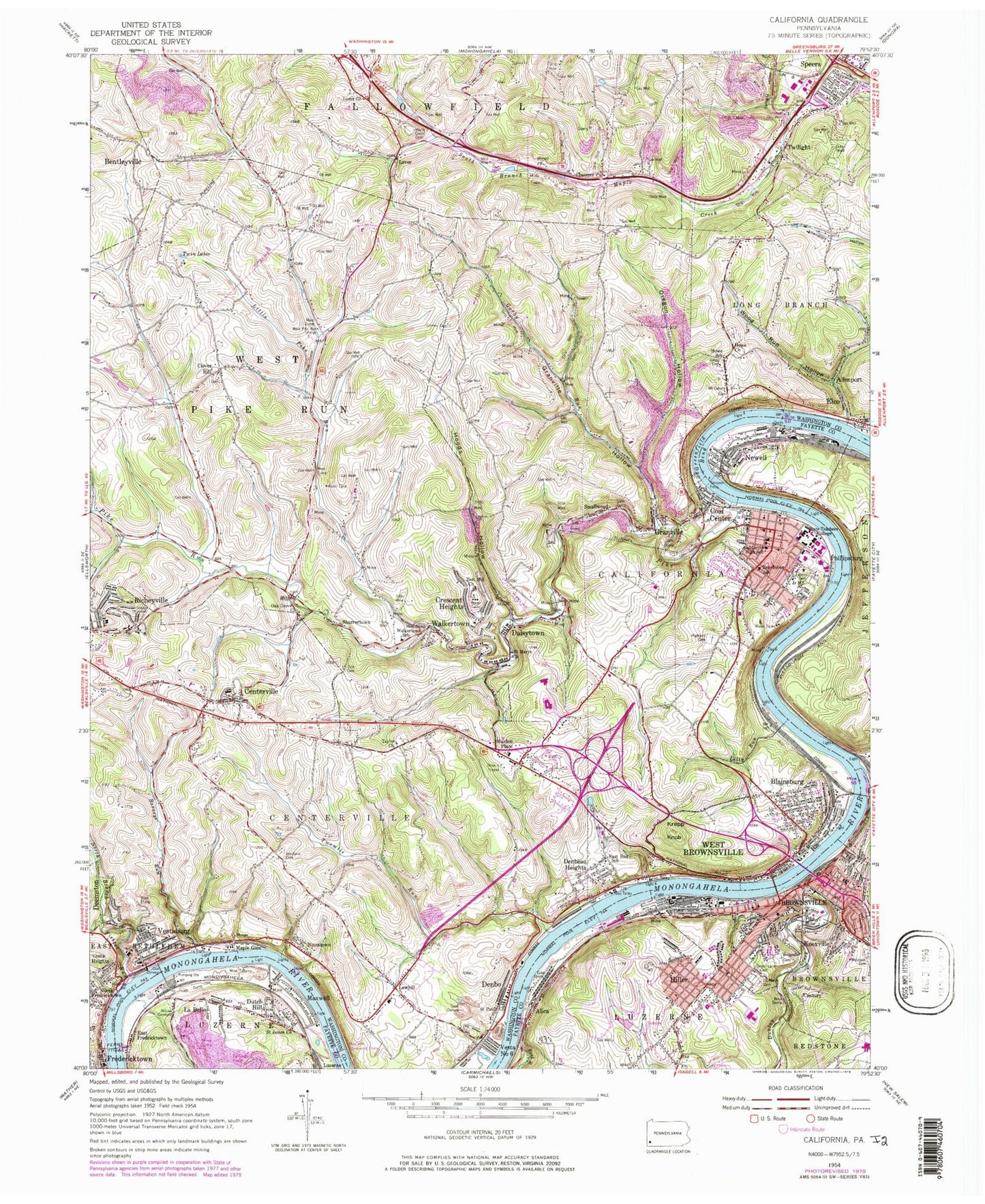
Classic USGS California Pennsylvania 7.5'x7.5' Topo Map
Couldn't load pickup availability
Historical USGS topographic quad map of California in the state of Pennsylvania. Typical map scale is 1:24,000, but may vary for certain years, if available. Print size: 24" x 27"
This quadrangle is in the following counties: Fayette, Washington.
The map contains contour lines, roads, rivers, towns, and lakes. Printed on high-quality waterproof paper with UV fade-resistant inks, and shipped rolled.
Contains the following named places: Rush Run, Alica, Barneys Run, Binnstown, Blainsburg, Bridgeport Cemetery, California, California High School, Centerville, Clover Hill, Coal Center, Crescent Heights, Daisytown, Denbeau Heights, Denbo, Dunlap Creek, Dutch Hill, East End School, East Fredricktown, Phillipsburg Cemetery, Ebenezer Church, Fishpot Run, Fredericktown, Gorby Run, Granville, Granville Hollow, Green Lane Cemetery, Greenfield Bend, Gregg Cemetery, Grimes Cemetery, Highland Cemetery - West, Hiller, Hoods Hollow, Howe Church, Howe School, Knoxville, Krepp Knob, La Belle, Lilly Run, Little Pike Run, Lover Church, Lowhill, Maple Creek Cemetery, Maple Glen, Maxwell, Newell, North Branch Fishpot Run, Oak Grove Church, Oregon Hollow, Philipsburg, Pike Mine, Pike Run, Redstone Creek, Republican School, Saint James Church, Saint Marys Roman Catholic Cemetery, Saint Marys Church, Saint Pauls Church, Sharrertown, Simpson Ferry, Smallwood, Speers, Taylor Church, Twilight, Twilight Hollow, Twin Lakes, Twomile Run, Vesta Heights, Vesta Number Six, Vestaburg, Walkertown, Walkertown School, West Brownsville, West Pike Run Grange, Westland Cemetery, Wood Run Hollow, Zion Cemetery, Zion Hill Church, Maxwell Pool, WVCS-FM (California), WESA-FM (Charleroi), WASP-AM (Brownsville), WESA-AM (Charleroi), Wood Run, Moffitts Mills, Marchandville, Century, Lover, Malden Place, California Overlook, Peoples School (historical), Lucyville, California University of Pennsylvania, Hiller Elementary School, Brownsville, Borough of Brownsville, Borough of Newell, Borough of California, Borough of Centerville, Borough of Coal Center, Borough of Elco, Borough of Long Branch, Borough of Speers, Borough of Twilight, Borough of West Brownsville, Township of West Pike Run, Noss Annex, Noss Hall, Pollock Building, Steele Hall, Vulcan Hall, Azorsky Hall, Clyde Hall, Coover Annex, Dixon Hall, Downey-Garofalo Health Center, Duda Hall, Eberly Hall, Hamer Hall, Herron Hall, Kara Alumni House, Keystone Hall, Longanecker Hall, Manderino Library, Natali Student Center, New Science Hall, Hiller Census Designated Place, California Public Library, California University Teacher Enhancement Center, Toddlers Patch Child Care Center, Pace School, Intermediate Unit 1 School, Hiller Volunteer Fire Department Station 21, Brownsville Fire Company 1 Station 5, Luzerne Township Volunteer Fire Company Station 23, California Volunteer Fire Department Station 23, West Brownsville Volunteer Fire Company, Denbo Vesta Six Volunteer Fire Company Station 19, South Brownsville Volunteer Fire Company 1 Station 6, Newell Volunteer Fire Company Station 30, Brownsville Ambulance Service, Brownsville Ambulance Service, Brownsville Bridge, Fredericktown Post Office, Daisytown Post Office, Brownsville Police Department, Coal Center Post Office, California Post Office, Hiller Post Office, Newell Post Office, La Belle Post Office, Vestaburg Post Office, Brownsville Post Office, California University Police, Old Jewish Cemetery, Christ Episcopal Graveyard, Taylor Cemetery, Woodlawn Cemetery, Saint Nicholas Cemetery, Saint Peters Cemetery, First United Methodist Cemetery