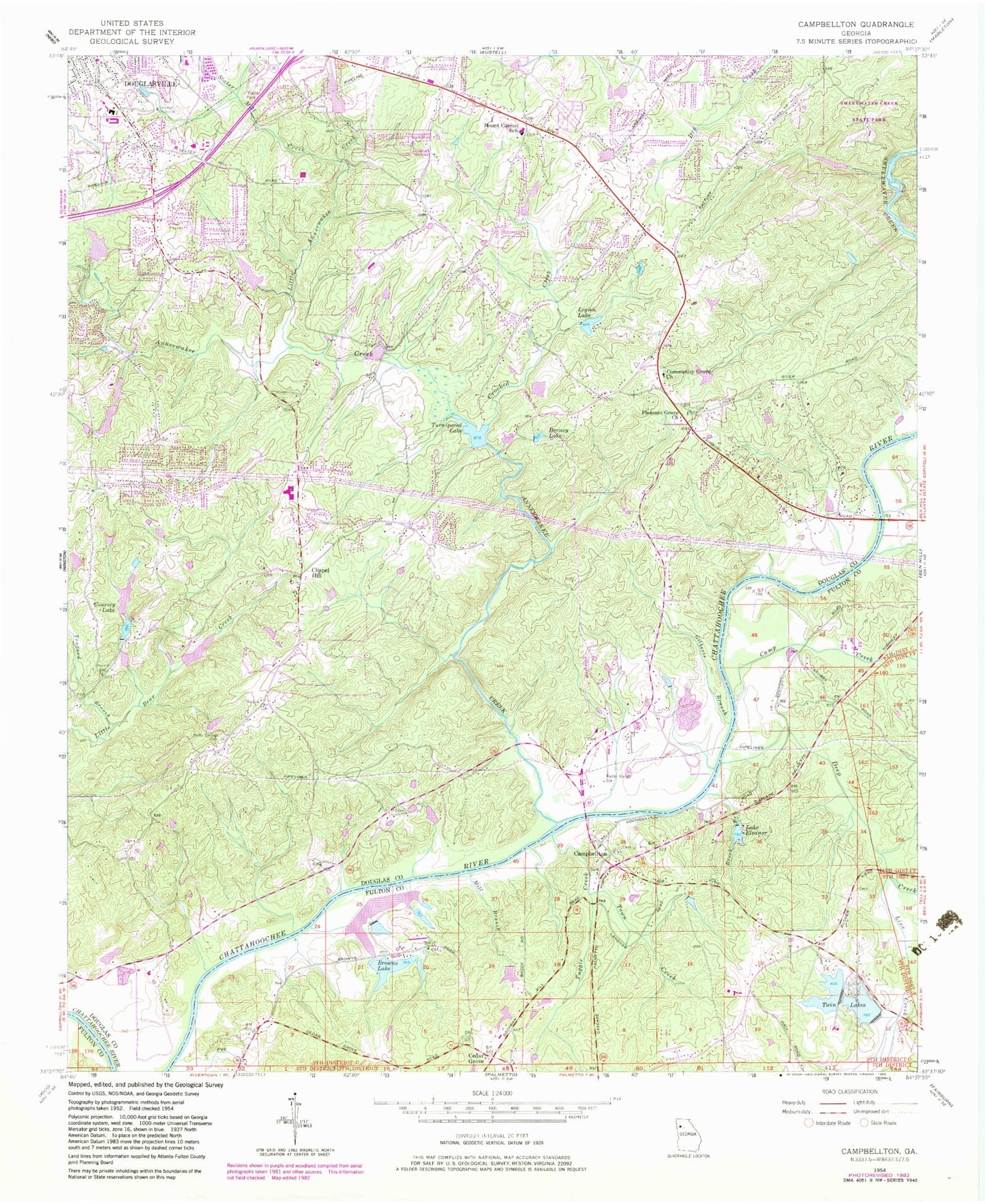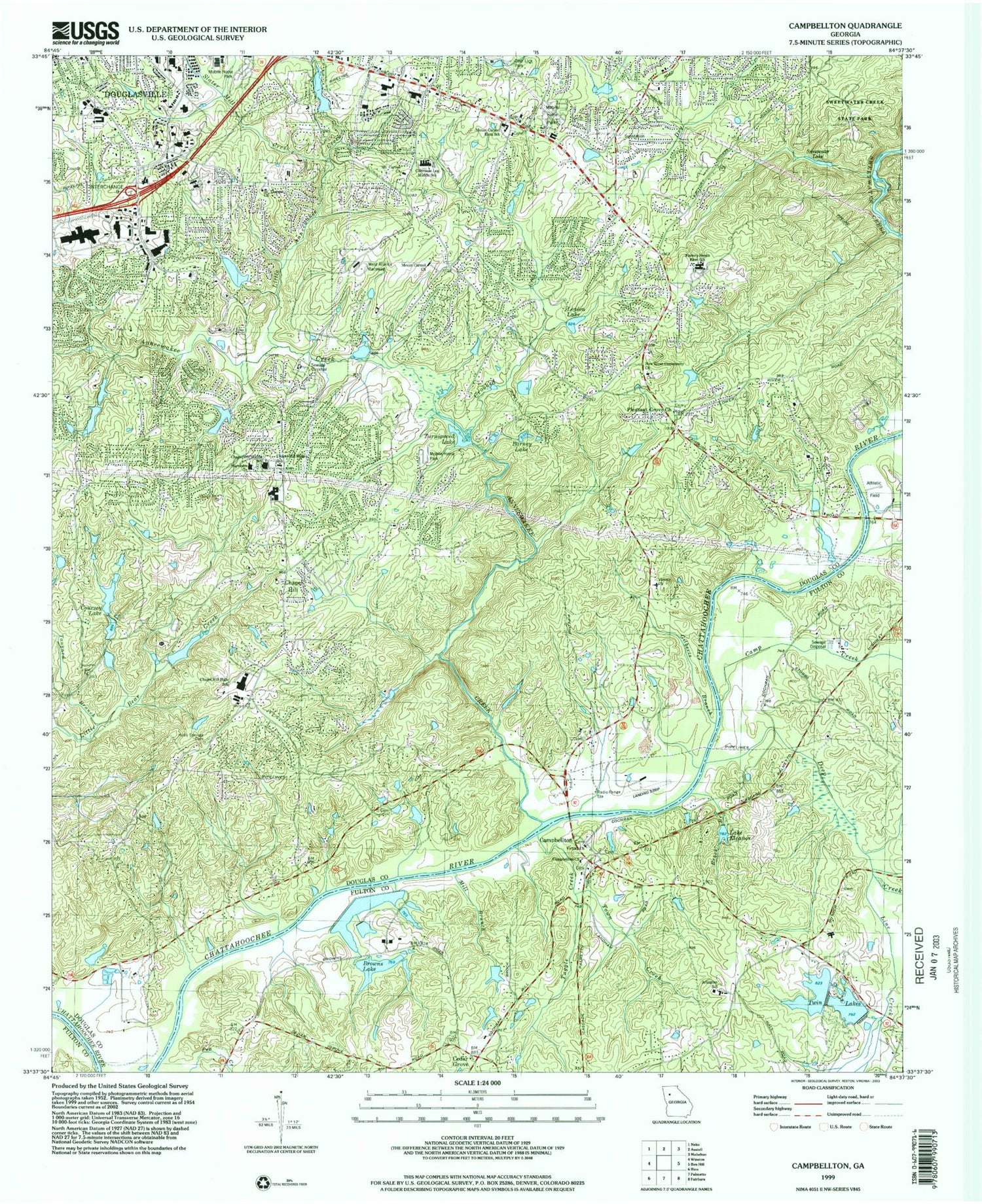
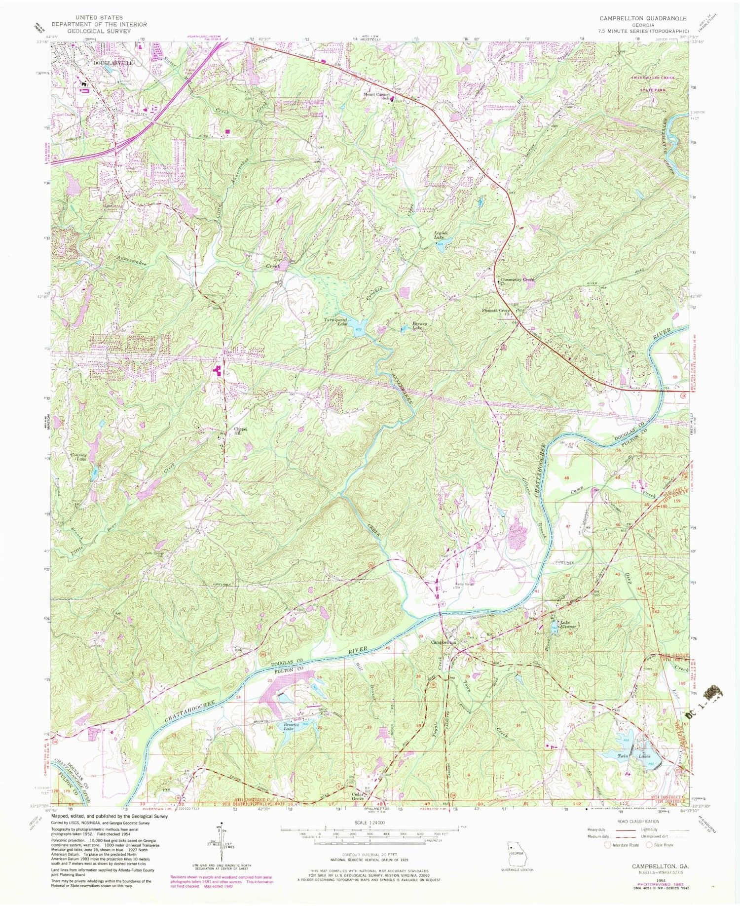
MyTopo
Classic USGS Campbellton Georgia 7.5'x7.5' Topo Map
Couldn't load pickup availability
Historical USGS topographic quad map of Campbellton in the state of Georgia. Typical map scale is 1:24,000, but may vary for certain years, if available. Print size: 24" x 27"
This quadrangle is in the following counties: Douglas, Fulton.
The map contains contour lines, roads, rivers, towns, and lakes. Printed on high-quality waterproof paper with UV fade-resistant inks, and shipped rolled.
Contains the following named places: Line Creek, Barney Lake, Brock Branch, Browns Lake, Camp Creek, Community Grove Church, Crooked Creek, Deep Creek, Lake Eleanor, Holly Springs Cemetery, Legion Lake, Little Anneewakee Creek, Mill Branch, Mount Carmel Elementary School, Pleasant Grove Church, Slater Mill Creek, Tanyard Branch, Town Creek, Tuggle Creek, Turnipseed Lake, Twin Lakes, Cedar Grove, Chapel Hill, Campbellton, Leatherwood Lake Dam, Leatherwood Lake, Patterson Lake Dam, Patterson Lake, Shawnee Lake Dam, Shawnee Lake, Anneewakee Lake Dam, Anneewakee Lake, Monroe Lake Dam, Monroe Lake, Browns Lake Dam, Mid Lake Dam, Mid Lake, Twin Lakes Dam Number Two, Twin Lakes Number 2, Upper Twin Lake Dam, Upper Twin Lake, Big Lake Dam, Big Lake, Small Browns Lake Dam, Small Browns Lake, Groover Lake Dam, Groover Lake, Austin North Lake Dam, Austin North Lake, Douglasville Lake Dam, Douglasville Lake, Coursey Lake Dam, Sweetwater Lake Dam, Sweetwater Lake, Cohen Lake Dam, Cohen Lake, Legion Lake Dam, Chattahoochee Air Park, Miller Farm Airport, Anneewakee Creek, Coursey Lake, Gilberts Branch, Alta Vista, Anneewakee, Anneewakee Estates, Anneewakee Heights, Arbor Heights Church, Bible Church, Blair Heights, Britt, Captains Quarters, Carmel Chase, Carmel Farms, Chapel Hill Elementary School, Chapel Hill Middle School, Chestnut Log, Chestnut Log Middle School, Creek Indian, Deer Lick Park, Del Ridge, Dogwood Acres, Dorris, Doublegate, Douglas County High School, Douglas Estates, Wellstar Douglas Hospital, Evergreen, Factory Shoals Elementary School, Five Notch Acres, Flagview Mobile Home Park, Flowers Estates, Glen Villa, Heritage Valley, Hilderbrand, Holland Manor, Hyde Park, Ivey Estates, Longview Estates, McKoy Cemetery, Meadowview, Mount Carmel Church, Mount Carmel Recreation Park, New Hope Church, Rebel Trail, Reynolds Estates, Rolling Hills, Salem, Shawnee Lake Estates, Shelby Forest, South Ridge, Southern Manor, Springhill Estates, Springwood Village, Stewart Woods, Tara Woods, The Meadows North, Timber Valley, Tranquil Church, Victory Church, Warren Heights, West Atlanta Raceway, Western Pines, Whispering Woods Estates, Windwood Village, Campbellton Street Post Office, Arlington Christian School, Butner Junction, Corn Creek Cove, Campbellton Church, Campbellton Ferry (historical), Mecca (historical), Douglasville-Lithia Springs Division, Douglasville Police Department, Douglas County Fire Department Station 5, Douglas County Chamber of Commerce, Douglas County Health Department, Douglas County Fire Department Station 6, Douglas County Water and Sewer Administration Building, Douglasville Pavillion Shopping Center, Douglasville Promenade Shopping Center, Fairburn Station Shopping Center, Midway Village Shopping Center, Paradise Crossing Shopping Center, Arbor Place Mall, Arlington Christian School, Central Church Station Shopping Center, Cloverleaf Village Shopping Center, City of Douglasville, Chapel Hill High School, Harvester Christian Academy, Strayer University Douglasville Campus, Holly Springs Elementary School, The Army of the Lord Christian Academy, Factory Shoals Middle School, New Manchester Elementary School, Inner Harbour School, Inner Harbour Treatment Center for Children and Families, Chapel Hill Road Cemetery, Pleasant Grove Cemetery