MyTopo
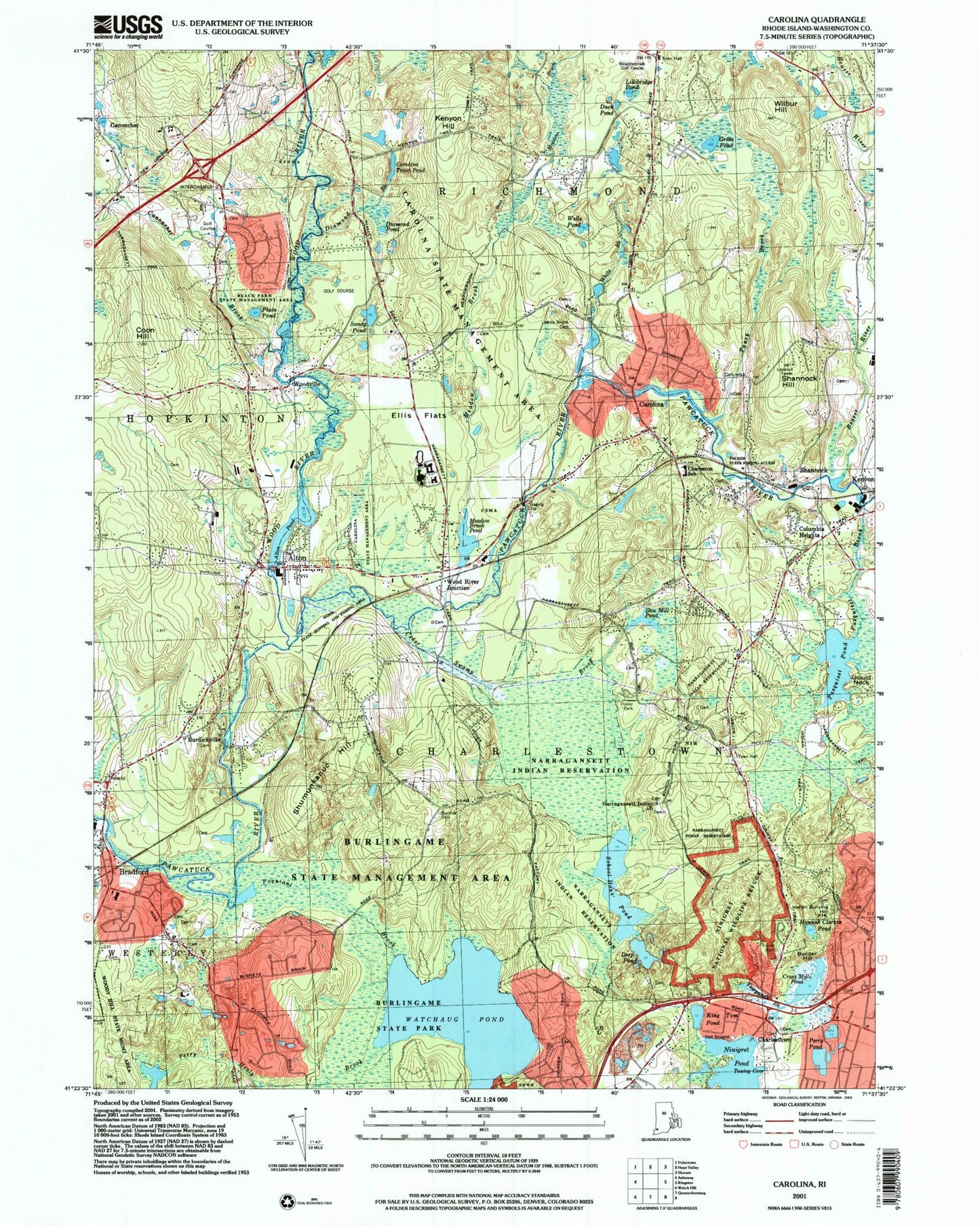
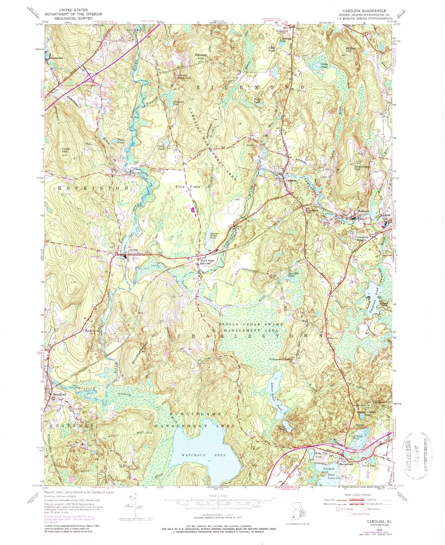
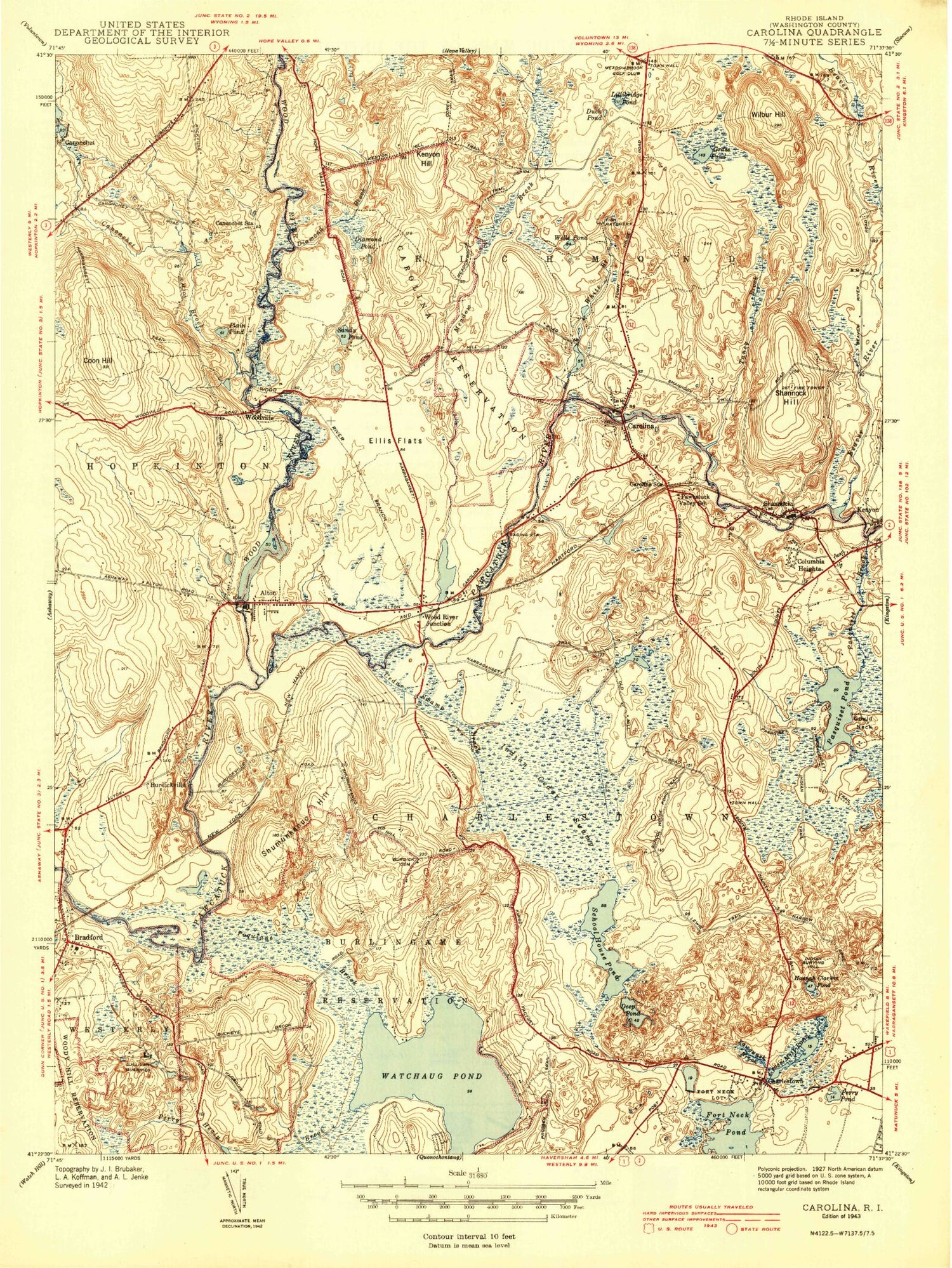
Classic USGS Carolina Rhode Island 7.5'x7.5' Topo Map
Couldn't load pickup availability
Historical USGS topographic quad map of Carolina in the state of Rhode Island. Typical map scale is 1:24,000, but may vary for certain years, if available. Print size: 24" x 27"
This quadrangle is in the following counties: Washington.
The map contains contour lines, roads, rivers, towns, and lakes. Printed on high-quality waterproof paper with UV fade-resistant inks, and shipped rolled.
Contains the following named places: Wood River, Tanyard Brook, Grassy Point, Bradford, Watchaug Pond, Poquiant Brook, Shumunkanuc Hill, Brudickville, Cedar Swamp Brook, Saw Mill Pond, Columbia Heights, Pasquiset Brook, Pasquiset Pond, School House Pond, Deep Pond, King Tom Pond, Tautog Cove, Yawgunsk Brook, Cross Mills Pond, Charlestown, Perry Pond, Border Hill, Hannah Clarkin Pond, Indian Burying Hill, Coon Hill, Canonchet, Canonchet Brook, Plain Pond, Woodville, Sandy Pond, Alton, Alton Pond, Wood River Junction, Meadow Brook Pond, Diamond Pond, Diamond Brook, Carolina Trout Pond, Kenyon Hill, Meadow Brook, White Brook, Wells Pond, Duck Pond, Lillibridge Pond, Grass Pond, Carolina, Taney Brook, Shannock, Shannock Hill, Kenyon, Wilbur Hill, Gould Neck, Burdickville, Wood River Junction Dam, Alton Pond Dam, Horseshoe Falls Dam, Woodville Pond, Woodville Pond Dam, Browning Isles (historical), Carolina Station, Coronation Rock, Crying Rocks, Fort Neck, Fort Ninigret, Ellis Flats, Beaver River, Perry Healy Brook, Town of Richmond, Joseph Boss Lot Cemetery, Boulder HIlls Country Club, Bradford School, Bramen Plot, Burdick Cemetery, Burlingame State Park Beach, Canochet Station, Carolina Management Area, Carolina Post Office, Carolina Village Historic District, Chariho Area Career and Technical Center, Chariho Regional High School, Chariho Regional Middle School, Charlestown Elementary School, Charlestown Historical Society Building, Charlestown Historical Society Schoolhouse (historical), Cross Mills Cemetery, Charlestown School, Charlestown Town Hall, Church of the Holy Spirit, Clark Memorial Library, Cross Mills Public Library, Doctor Isaac Collins Lot Cemetery, Enchanted Forest, Carpenter Fenner Lot Cemetery, Fones Palmer Plot, Frosty Drew Memorial Nature Center, Frosty Drew Observatory, Gardiner - Green Lot Cemetery, George Babcock Lot Cemetery, Geer - Hall Lot Cemetery, Hezekiah Collins Lot Cemetery, Horseshoe Falls, Stephen Hoxsie Lot Cemetery, Hoxsie - Cayer Lot Cemetery, Indian Cedar Swamp, Indian Cedar Swamp Management Area, Joseph Burdick Lot, Kimball Wildlife Refuge, Lindhbrook Country Club, Narragansett Indian Church, Narragansett Indian Church, Narragansett Indian Longhouse and Cultural Center, Nathan Collins Plot, Nathan Kinyon Lot Cemetery, Nichols Plot, Ninigret Beach, Ninigret Park, Octagon House, Palmer Family Plot, Richmond Country Club, Royal Burial Ground, Saint Marys Church, Sahnnock Historic District, Shannock Mill Complex, Shannock Post Office, Sullivan Quarries (historical), White Brook Cemetery, Wood River Junction Post Office, Worden Plot, Narragansett Reservation, Burlingame State Management Area, Burlingame State Park, Woody Hill State Management Area, Wood State Hunting and Fishing Area, Black Farm State Management Area, Packer State Fishing Access, Wood River Health Services, Hope Valley Wyoming Fire District Station 2, Bradford Volunteer Fire Department, Charlestown - Richmond Fire Station, Cross Mills Fire Station, Richmond - Carolina Fire District Station 1, District Schoolhouse Number 2 (historical), Arnolda, Scotch Pond (historical), Stub Point, Carolina Census Designated Place, Charlestown Census Designated Place, Harvey Island, Hell Island, Twin Islands, Bradford Post Office, Worden Family Cemetery, Indian Burial Ground, David Larkin Lot Cemetery, Jonathan Maxon Lot Cemetery, Richmond Historical Cemetery 92, Isaac Collins Lot Cemetery, Wood River, Tanyard Brook, Grassy Point, Bradford, Watchaug Pond, Poquiant Brook, Shumunkanuc Hill, Brudickville, Cedar Swamp Brook, Saw Mill Pond, Columbia Heights, Pasquiset Brook, Pasquiset Pond, School House Pond, Deep Pond, King Tom Pond, Tautog Cove, Yawgunsk Brook, Cross Mills Pond, Charlestown, Perry Pond, Border Hill, Hannah Clarkin Pond, Indian Burying Hill, Coon Hill, Canonchet, Canonchet Brook, Plain Pond, Woodville, Sandy Pond, Alton, Alton Pond, Wood River Junction, Meadow Brook Pond, Diamond Pond, Diamond Brook, Carolina Trout Pond, Kenyon Hill, Meadow Brook, White Brook, Wells Pond, Duck Pond, Lillibridge Pond, Grass Pond, Carolina, Taney Brook, Shannock, Shannock Hill, Kenyon, Wilbur Hill, Gould Neck, Burdickville, Wood River Junction Dam, Alton Pond Dam, Horseshoe Falls Dam, Woodville Pond, Woodville Pond Dam, Browning Isles (historical), Carolina Station, Coronation Rock, Crying Rocks, Fort Neck, Fort Ninigret, Ellis Flats, Beaver River, Perry Healy Brook, Town of Richmond, Joseph Boss Lot Cemetery, Boulder HIlls Country Club, Bradford School, Bramen Plot, Burdick Cemetery, Burlingame State Park Beach, Canochet Station, Carolina Management Area, Carolina Post Office, Carolina Village Historic District, Chariho Area Career and Technical Center, Chariho Regional High School, Chariho Regional Middle School