MyTopo
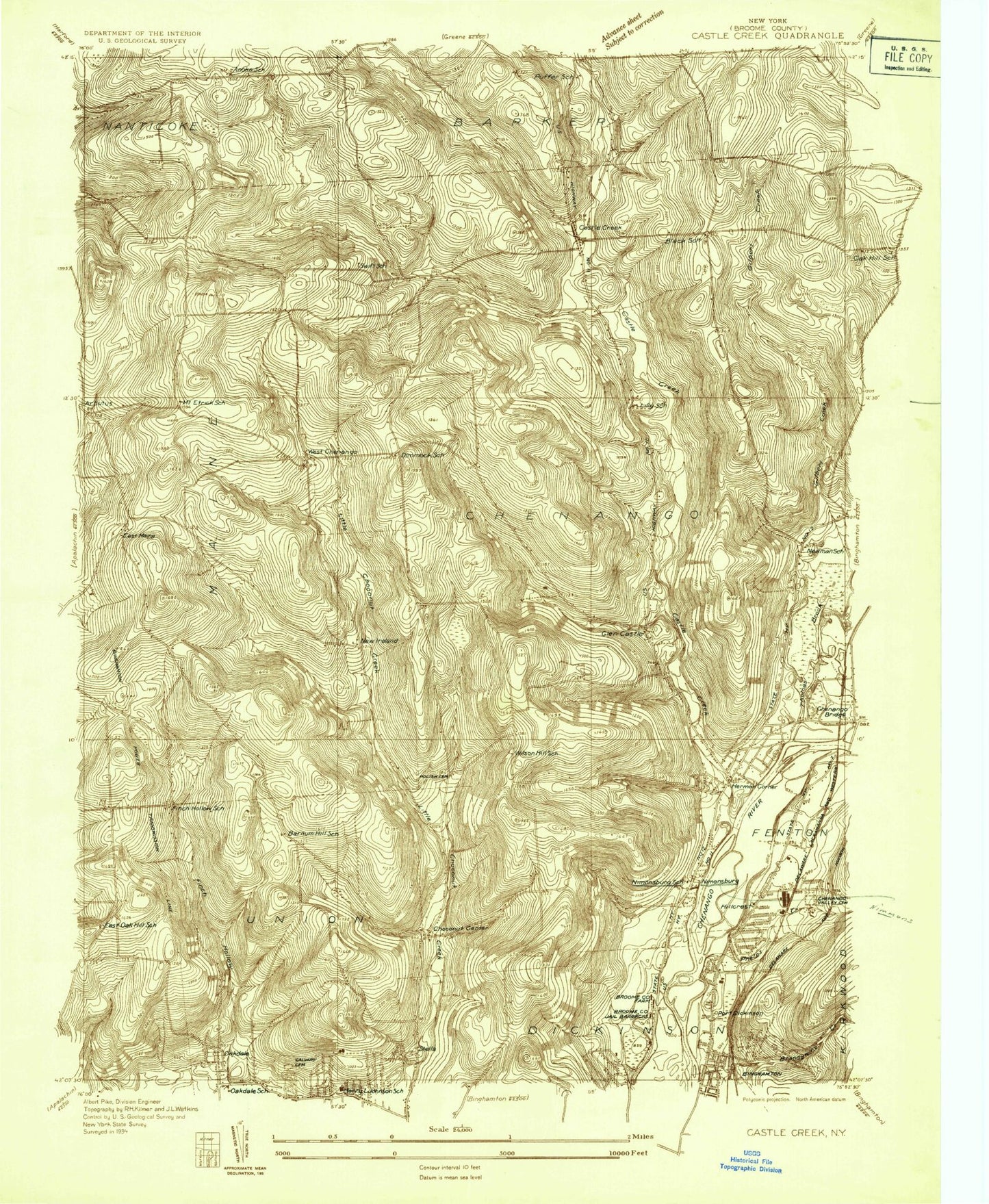
Classic USGS Castle Creek New York 7.5'x7.5' Topo Map
Couldn't load pickup availability
Historical USGS topographic quad map of Castle Creek in the state of New York. Map scale may vary for some years, but is generally around 1:24,000. Print size is approximately 24" x 27"
This quadrangle is in the following counties: Broome.
The map contains contour lines, roads, rivers, towns, and lakes. Printed on high-quality waterproof paper with UV fade-resistant inks, and shipped rolled.
Contains the following named places: Airport Drive-In Theater, All Saints Cemetery, Apple Hills Fruit Farm, Baptist Church Cemetery, Barnum Hill School, Bethesda Bible Church, Binghamton Police Department, Black School, Brooks Creek, Broome Community College, Broome County Home, Broome County Jail Farm, Broome County Landfill, Calvary Cemetery, Calvary's Love Assembly of God, Castle Creek, Castle Creek Post Office, Cecil C Tyrell Learning Resources Center, Central Baptist Church, Chenango Ambulance Service, Chenango Bridge Post Office, Chenango Fire Company Station 1, Chenango Fire Company Station 2 Castle Creek, Chenango Town Hall, Chenango Valley Cemetery, Choconut Center, Choconut Center Cemetery, Choconut Center United Methodist Church, Choconut Center Volunteer Fire Company, Community Baptist Church, Cutler Botanic Gardens, Darwin R Wales Administration Building, Deyo Hill, Dimmick Hill Cemetery, Dimmock Hill Golf Course, Dimmock School, East Maine, East Maine Cemetery, East Maine Fire Company, East Oak School, Elizabeth Church Manor Nursing Home, Ely Park, Fenton Free Library, Finch Hollow, Finch Hollow School, First Church of the Nazarene, Fortress Estates, Front Drive-In, Glen Castle, Glen Castle Cemetery, Glen Castle Creek, Greater Binghamton Airport Aircraft Rescue and Fire Fighting Unit, Greater Binghamton Airport/Edwin A Link Field, Greene Point, Hillcrest Elementary School, Hillcrest Shopping Center, Hillcrest Volunteer Fire Company, Hinmans Corners, James G Johnston Memorial Nursing Home, Johnson City Elementary - Intermediate School, Johnson City Elementary - Primary School, Johnson City Middle School, Kingdom Hall of Jehovahs Witnesses, Lees Mobile Home Park, Lilly Cemetery, Lilly School, Maple Grove Cemetery, Mount Etrick School, New Ireland, Newmans Corner, Nimmonsburg Cemetery, Nimmonsburg United Methodist Church, Oakdale Mall Shopping Center, Ogden-Hillcrest Methodist Church, Paul F Titchener Hall, Phelps Creek, Port Dickinson, Port Dickinson Fire Station, Port Dickinson School, Port Dickinson Village Hall, Potato Creek, Puffer School, Sacred Heart Cemetery, Saint Catherine Convent, Saint Catherine's Roman Catholic Church, Saint Catherine's School, Saint Christophers Church, Saint John Ukranian Orthodox Parish Cemetery, Saint Johns Pond, Saint Louise Manor Assisted Living Facility, Saint Stanislaus Kostka Roman Catholic Cemetery, Thomas Creek, Town of Chenango, Town of Dickinson, United With Christ, Village of Port Dickinson, West Chenango, West Chenango United Methodist Church, Wilson Hill School, WMRV-FM (Endicott), ZIP Codes: 13744, 13901, 13905