MyTopo
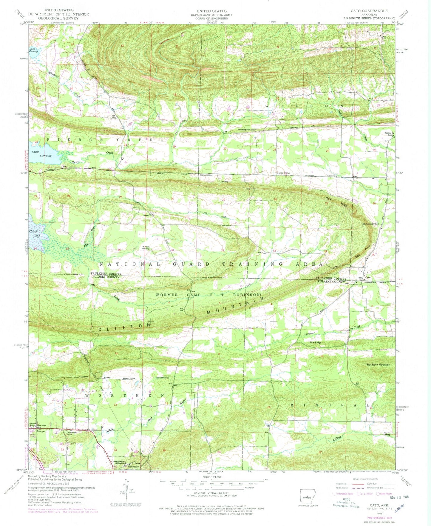
Classic USGS Cato Arkansas 7.5'x7.5' Topo Map
Couldn't load pickup availability
Historical USGS topographic quad map of Cato in the state of Arkansas. Typical map scale is 1:24,000, but may vary for certain years, if available. Print size: 24" x 27"
This quadrangle is in the following counties: Faulkner, Pulaski.
The map contains contour lines, roads, rivers, towns, and lakes. Printed on high-quality waterproof paper with UV fade-resistant inks, and shipped rolled.
Contains the following named places: Blue Hill School, Cato, Cato Point, Cedar Heights Church, Chadwick Creek, Faulkner Gap Church, Flat Rock Mountain, Immaculate Heart of Mary Church, Jim Creek, Mile Creek, Morgan, Mount Psyam Cemetery, Oakwood Church, Pierce Creek, Pine Ridge, Rock Ridge, Shaw School, Brockington Corner, Gentry Corner, Antioch School (historical), Boone Pond, Camp Robinson State Wildlife Management ARea, Caney Creek, Chadwick (historical), Mount Meto School (historical), Mount Pisgah School (historical), Oakland School (historical), Township of Pierce Creek (historical), Township of Wilson, Blue Hill, Cato Cemetery, Cato Methodist Church, Immaculate Heart of Mary School, Union School (historical), Township of Worthen (historical), Cato Church, Clifton Mountain, Meers Lake Dam, Meers Lake, Bobwhite Hill Ranch Airport (historical), Cato Volunteer Fire Department, Oak Grove Fire Department - District 25 Central Station, Camp Joseph T Robinson, Blue Hill School, Cato, Cato Point, Cedar Heights Church, Chadwick Creek, Faulkner Gap Church, Flat Rock Mountain, Immaculate Heart of Mary Church, Jim Creek, Mile Creek, Morgan, Mount Psyam Cemetery, Oakwood Church, Pierce Creek, Pine Ridge, Rock Ridge, Shaw School, Brockington Corner, Gentry Corner, Antioch School (historical), Boone Pond, Camp Robinson State Wildlife Management ARea, Caney Creek, Chadwick (historical), Mount Meto School (historical), Mount Pisgah School (historical), Oakland School (historical), Township of Pierce Creek (historical), Township of Wilson, Blue Hill, Cato Cemetery, Cato Methodist Church, Immaculate Heart of Mary School, Union School (historical), Township of Worthen (historical), Cato Church, Clifton Mountain, Meers Lake Dam, Meers Lake, Bobwhite Hill Ranch Airport (historical), Cato Volunteer Fire Department, Oak Grove Fire Department - District 25 Central Station, Camp Joseph T Robinson