MyTopo
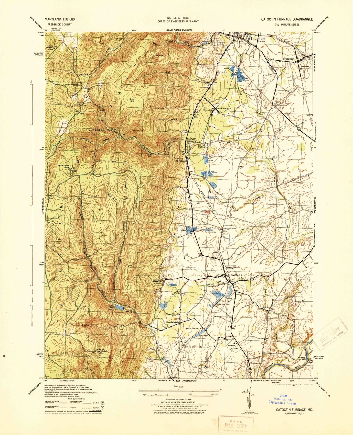
Classic USGS Catoctin Furnace Maryland 7.5'x7.5' Topo Map
Couldn't load pickup availability
Historical USGS topographic quad map of Catoctin Furnace in the state of Maryland. Typical map scale is 1:24,000, but may vary for certain years, if available. Print size: 24" x 27"
This quadrangle is in the following counties: Frederick.
The map contains contour lines, roads, rivers, towns, and lakes. Printed on high-quality waterproof paper with UV fade-resistant inks, and shipped rolled.
Contains the following named places: Bear Branch, Black Rock, Buzzard Branch, Coffee Hollow, Creagerstown Station, Devilbiss Bridge, Dry Branch, Fishing Creek, Fishing Creek Reservoir, High Run, Lake View Station, Lewistown, Little Fishing Creek, Little Hunting Creek, Locust Grove Station, Mount Prospect Church, Mountaindale Station, Muddy Run, Oxys Hollow, Philips Delight School, Red Hill Station (historical), Salamander Rock, Sand Flat, Sandy Run, Steep Creek, Thurmont, Union Chapel, Bethel, Blue Mountain, Bobs Hill, Cat Rock, Catoctin Furnace, Graceham, Jimtown, Mountaindale, Utica, Foxville Lookout Tower, Hamburg Lookout Tower, Lewistown State Fish Hatchery, Fishing Creek Dam, Bobs Hill Overlook, Cliffton Estates, Heatherview, Hunting Creek Acres, Laurelcrest, Leisure Mountain, Lost Eden, Tuscarora Springs, White Rocks, Willis Acres, Altogether, Baugher Woods, Bethel Evangelical Lutheran Church, Blue Mountain School (historical), Catoctin Iron Furnace (historical), Catoctin Furnace Historic District, Catoctin Furnace School (historical), Catoctin Mountain Zoological Park, Catoctin Parish Episcopal Church, Covered Bridge Estates, Devilbiss Estates, East End Park, Eicholz Mill (historical), Fraley Acres, Free Farms, Gateway, Graceham Cemetery, Graceham Moravian Church, Harmony Hill, Highland Mill (historical), Hunting Creek School (historical), Kesselring, Knowles, Lady of Mount Carmel Catholic Church, Larvadale Estates, Lewisdale Estates, Lewistown Elementary School, Lewistown Mill (historical), Locust Grove, Mills Manor, Mount Prospect Estates, Mount Prospect Hill Cemetery, Mountain Gate Plaza Shopping Center, Mountaindale Brethren Church, Mountaindale Cemetery, Northaven Farms, Poplar Knob, Saint Johns Evangelical Lutheran Church, Saint Paul Lutheran Church, Saint Pauls Cemetery, Saint Pauls Evangelical Lutheran Church, Saint Pauls Reformed Church (historical), Sandy Run Estates, Stevens Airport (historical), Sunday, Thurmont Elementary School, Thurmont Industrial Park, Thurmont Library, Thurmont Middle School, Thurmont Overlook, Thurmont Park, Thurmont Post Office, Thurmont Town Hall, Thurmont United Methodist Church, Trinity United Church of Christ, Utica Covered Bridge, Utica Mills Estates, Williar, Ziegler Estates, Fish Hatchery Spring, Frank Bentz Memorial Lake, Manor Visitor Center, District 20 Lewistown, Thurmont Branch Library, Wolfsville Fire Company Number 1, Lewistown Volunteer Fire Company 22, Guardian Hose Company Number 10, Prince Georges County Police, Thurmont Police Department, New Carrollton Police Department, New Carrollton City Hall, Guardian Hose Company, Graceham Volunteer Fire Company Station 18, Pioneer Baptist Church School, Thurmont Primary School, Town of Thurmont, Tranquility Farm, Findale Farms, Stoney Lick Farm, Lambert Farms, Graceham Census Designated Place, Lewistown Census Designated Place