MyTopo
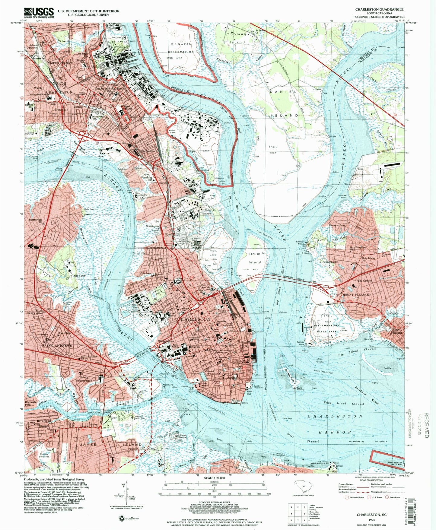
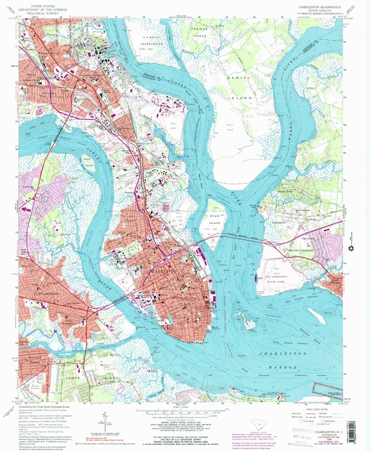
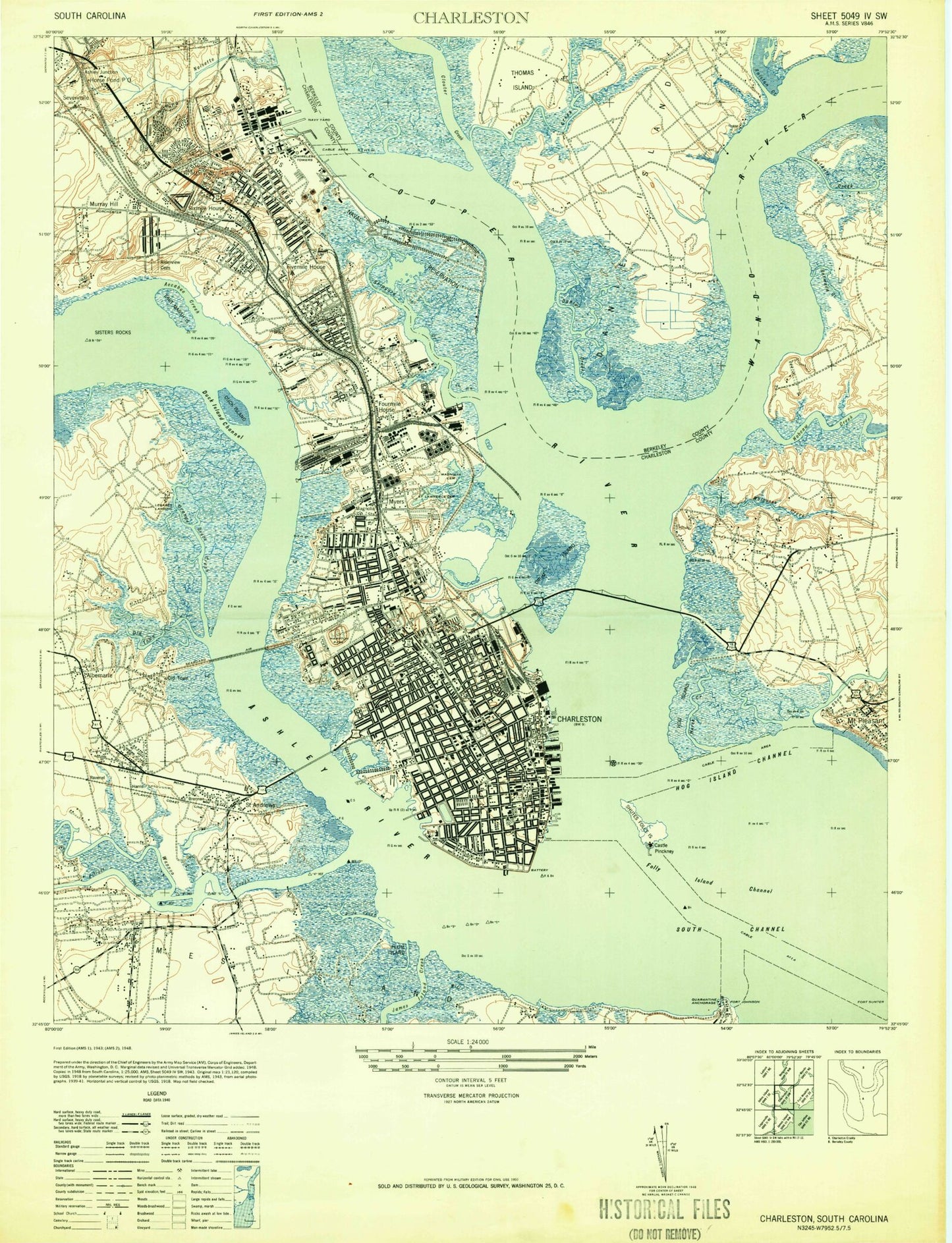
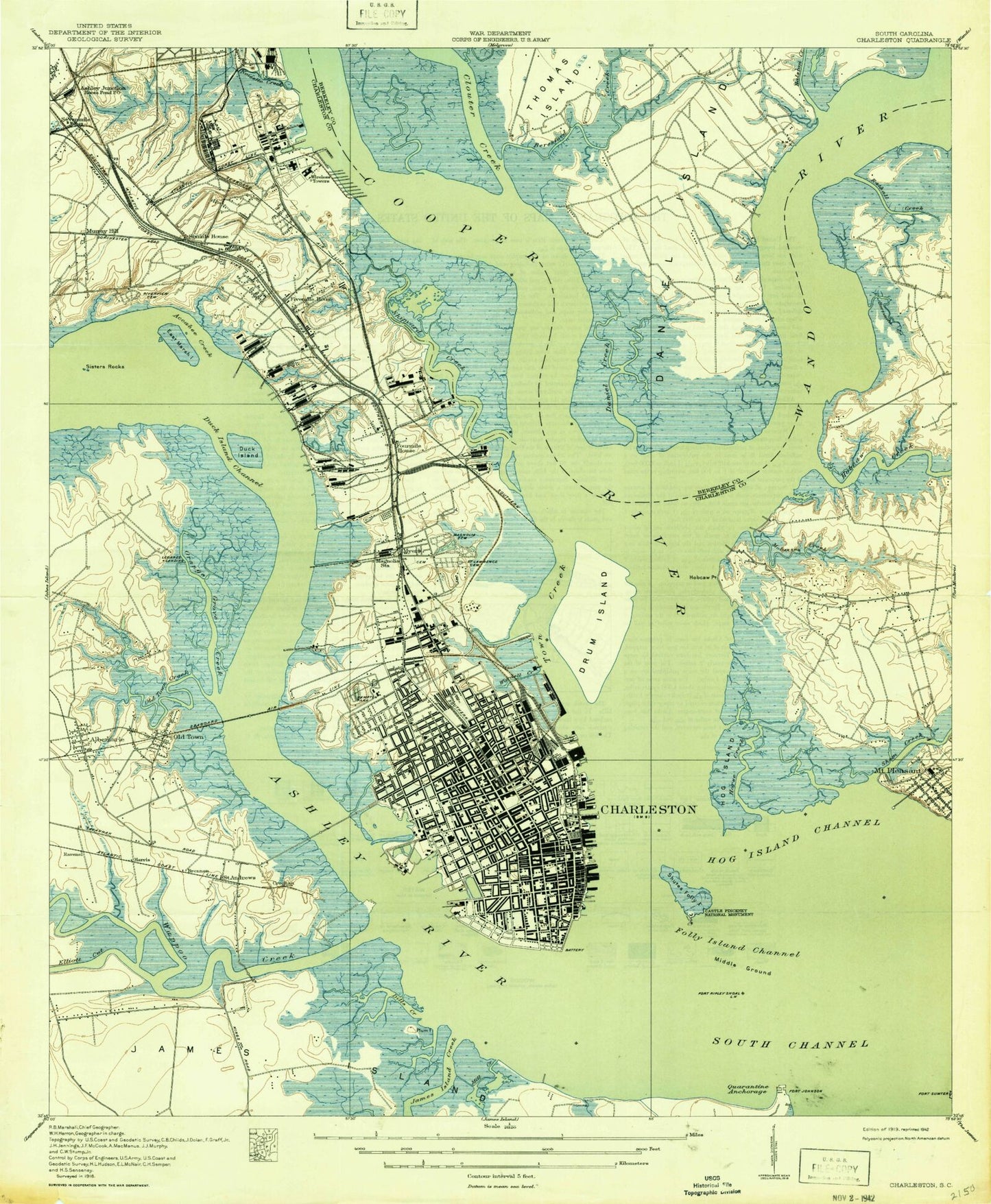
Classic USGS Charleston South Carolina 7.5'x7.5' Topo Map
Couldn't load pickup availability
Historical USGS topographic quad map of Charleston in the state of South Carolina. Typical map scale is 1:24,000, but may vary for certain years, if available. Print size: 24" x 27"
This quadrangle is in the following counties: Berkeley, Charleston.
The map contains contour lines, roads, rivers, towns, and lakes. Printed on high-quality waterproof paper with UV fade-resistant inks, and shipped rolled.
Contains the following named places: Accabee Flats, Adverse Cemetery, Albemarle Point, Albemarle Elementary School, Ashley Hall School, Ashley River, Ashley River Memorial Bridge, Beresford Creek, Bermuda Creek, Blessed Sacrament School, Brown Cemetery, Burke High School, Castle Pinckney, Charleston, Charleston Harbor, Charleston Heights, Clouter Creek, College of Charleston, Colonial Lake, Daniel Island Bend, Dill Creek, Drum Island, Duck Island, Duck Island Channel, East Bay Playground, East Bay School, East Marsh Island, Elliott Cut, Emanuel School, Fivemile Viaduct, Folly Island Channel, Fort Johnson Marine Biological Station, Fort Sumter National Monument, Freewill Church, Good Samaritan School, Good Shepherd Church, Haddrell Point, Hampton Park, Harmon Field, Hobcaw Creek, Hobcaw Point, Hobcaw Point, Hog Island Channel, Hog Island Reach, Holy Trinity Church, James Island Creek, Jenkins Orphanage, Jenkins School, Jenkins School, Kushiwah Creek, Live Oak Hall, Magnolia Cemetery, Mall Playground, Marion Square, Mary Ford Elementary School, Maryville, Medical College of South Carolina, Memorial Bridge, Mill Creek, Molasses Creek, Murray School, Myers Bend, Navy Yard Reach, Newmarket Creek, Noisette Creek, North Charleston, Oldtown Creek, Orangegrove Creek, Plum Island, Porter Academy (historical), Rathall Creek, Rebellion Reach, Remley Point, Rhett School, M R Rivers Middle School, Riverview Memorial Park, Rosemont School, Saint James Church, Saint John's Catholic School, Saint Lawrence Cemetery, Saint Peters Cemetery, Sevenmile Viaduct, Shem Creek, Shipyard Creek, Shutes Folly Island, Sisters Rocks, South Channel, Stoney Field, The Center, Thomas Island, Tillman Park, Town Creek, Wappoo Creek, Wappoo Creek Bridge, Washington Church, White Point Gardens, Woodahl Park, WOKE, Daniel Island Reach, Custom House Reach, Hog Island, Bennis Reach, Drum Island Reach, Town Creek Upper Reach, Town Creek Lower Reach, Crab Bank, Cooper River, Wando River, Ashley Junction, Avondale, Bethany Cemetery, Dorchester, Murray Landing, Myers, Old Town, Riverland Terrace, Saint Andrews, Scanlonville, Sevenmile, Sixmile, South Windermire, The Groves, Waylyn, Whipper-Barnoy, Cainhoy Plantation, Daniels Island Church (historical), Remleys (historical), Charleston Country Club, James Island Yacht Club, Baker Hospital, Daniel Island, Mary Bennett Murray Infirmary, Charleston Memorial Hospital, Ralston Creek, Beresford Creek, Medical University of South Carolina Heliport, Horse Reach, WOKE-AM (Charleston), WTMA-AM (Charleston), WUJM-AM (Charleston), WVVO-AM (Dorchester Terrace-Brentwood), WSSX-FM (Charleston), Archer School, Buist Academy, Military Magnet Academy, Chicora Elementary School, Fraser Elementary School, Courtenay School, Edmund A Burns Elementary School, John P. Grace Memorial Bridge (historical), Memminger Elementary School, Mitchell Elementary School, Northbridge Church, The Citadel, Ronald E McNair Elementary School, Academy of Fine Arts (historical), Advent Lutheran Church, Anson Borough Homes, Anson Street Presbyterian Church (historical), Asbury Memorial United Methodist Church, Ashley Forest, Ashley Plaza Mall Shopping Center, Ashley River Baptist Church, Ashley Shores, Ashleyville, Bayview Acres, Beth Elohim Synagogue, Beth Israel Congregation, Bethel United Methodist Church, Bishop England High School, Brith Sholom Beth Israel Synagogue, Broad Street Theater (historical), Byrnes Downs, Calvary African Methodist Episcopal Church, Calvary Baptist Church, Calvary Church (historical), Calvary Episcopal Church, Calvary Lutheran Church, Canaan Baptist Church, Cannon Park, Cannon Street Baptist Church, Carolina Yacht Club, Cathedral Church of Saint Luke and Saint Paul, Cathedral of Saint John the Baptist, Centenary United Methodist Church, Central Baptist Church, Central Reformed Methodist Union Episcopal Church, Charles A Brown High School, Charles Towne Landing, Charles Towne Village, Charleston City Hall, Charleston County, Charleston County Courthouse, Charleston County Health Center, Charleston County Jail, Charleston County Library, Charleston Hebrew Institute, Charleston Heights Baptist Church, Charleston Historic District, Charleston Library, Charleston Municipal Auditorium, Charleston Museum, Charleston Neck, Charleston Orphan House (historical), Charleston Post Office, Charlestowne Estates, Cherokee Place, Cherokee Place United Methodist Church, Chesterfield, Chicora Place, Chisolm Mill (historical), Church of Christ, Church of God, Church of God, Church of God, The Church of Jesus Christ of Latter Day Saints, Church of the Holy Communion, Church of the Most Blessed Sacrament, Church of the Nazarene, Circular Congregational Church, Citadel Square Baptist Church, City Market, Colin Grant Home for Aged Presbyterians, Confederate Museum, Cooper Estates, Country Club Estates, Cross Creek Shopping Center, Daniel Jenkins Homes, Dock Street Theatre, Dogwood Park, Dorchester-Waylyn Baptist Church, East Cooper Plaza Shopping Center, East Cooper Private School, Emanuel African Methodist Episcopal Church, Emanuel Synagogue, Fabian Shopping Center