
MyTopo
Classic USGS Cheboygan Michigan 7.5'x7.5' Topo Map
Couldn't load pickup availability
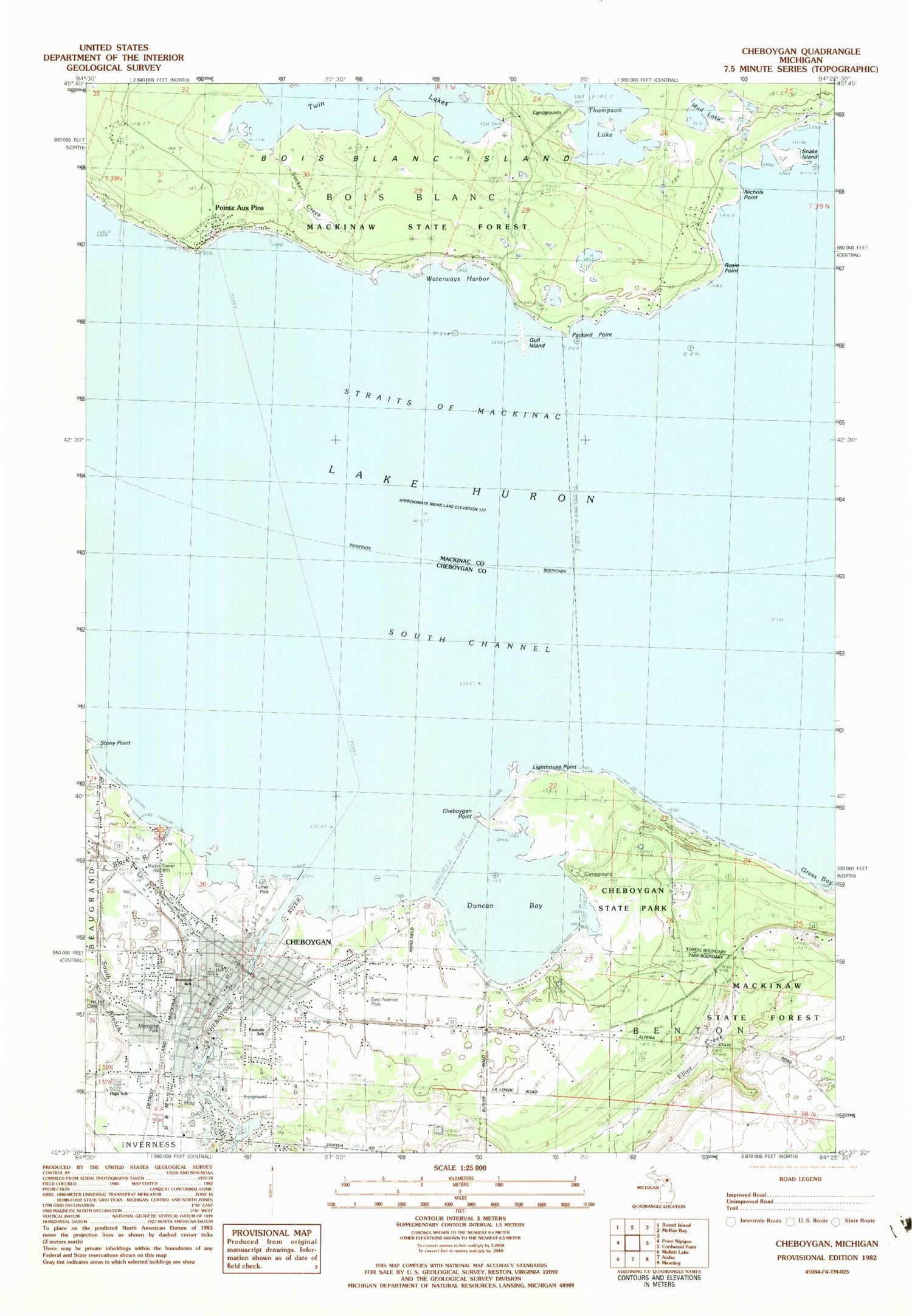
Historical USGS topographic quad map of Cheboygan in the state of Michigan. Map scale may vary for some years, but is generally around 1:24,000. Print size is approximately 24" x 27"
This quadrangle is in the following counties: Cheboygan, Mackinac.
The map contains contour lines, roads, rivers, towns, and lakes. Printed on high-quality waterproof paper with UV fade-resistant inks, and shipped rolled.
Contains the following named places: Bascule Bridge, Bishop Baraga School, Blessed Hope Baptist Church, Bois Blanc Island Fire Department, Bois Blanc Island Historical Marker, Bois Blanc Medical Clinic, Calvary Seventh-Day Adventist Church, Captains Three Marine Service, Cheboyan Station, Cheboygan, Cheboygan Area High School, Cheboygan Church of Christ, Cheboygan City Hall, Cheboygan County Courthouse, Cheboygan County Fairgrounds, Cheboygan County Museum, Cheboygan County Sheriff's Office, Cheboygan Crib Lighthouse, Cheboygan Health Care Center, Cheboygan Life Support Systems, Cheboygan Memorial Hospital, Cheboygan Middle School, Cheboygan Point, Cheboygan Police Department, Cheboygan Post Office, Cheboygan Public Library, Cheboygan River, Cheboygan State Park, Cheboygan Volunteer Fire Department, Church of Jesus Christ of Latter-Day Saints, City of Cheboygan, Cornerstone Christian School, Department of Natural Resources Field Office, Duncan Bay, Duncan Post Office, Durocher Dock and Dredge Incorporated, East Avenue Park, East School, Elliot Creek, Evangelical Covenant Church, Faith Baptist Church, First Church of Christ Scientist, First Congregational Church, Fourteen Foot Shoal Light, GEFS Marine Terminal, Grass Bay, Great Lakes, Gull Island, Huron Street Tabernacle, Jacob J Post House Historical Marker, Jail and Sheriff's Residence Historical Marker, Kiwanis Park, Lighthouse Point, Little Black River, Lund Cheboygan Harbor Marina, Major City Park, Mclaren Northern Michigan Hospital, Memorial Park, Michigan State Police Department, Mud Lake, Nichols Point, Northshore Community Church, Northshore Medical Clinic, Northwood Oil Company, Old Cheboygan County Courthouse Historical Marker, Ottawa Art Park, Packard Point, Pine Hill Cemetery, Pine Hill Cemetery Annex, Pines Elementary School, Pointe Aux Pins, Pointe Aux Pins Post Office, Resurrection Life Church, River Front Range Lighthouse, River of Life Chapel, Rivertown Marina, Rosie Point, Saint James Episcopal Church, Saint Mary Church Historical Marker, Saint Mary's and Saint Charles' Church, Saint Paul United Methodist Church, Saint Thomas Lutheran Church, School Number 7, Snake Island, Standard Oil Company, Stony Point, Sucker Creek, Thompson Lake, Thompson Lumber Company, Transfiguration Episcopal Church, Turner Park, Twin Lakes, United States Fish and Wildlife Service Dock, Washington Park, Waterway Harbor, WCBY-AM (Cheboygan), Wesleyan Community Church, West School


