
MyTopo
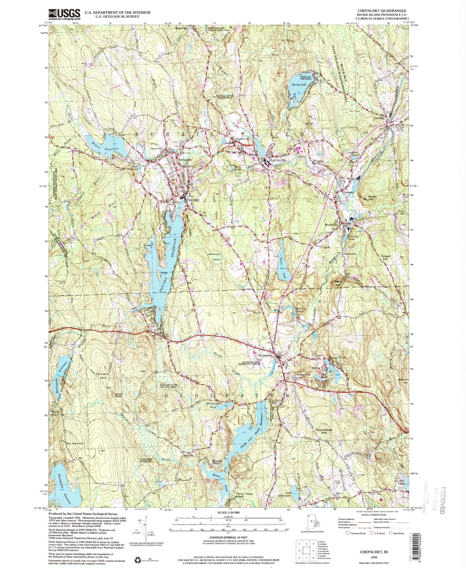
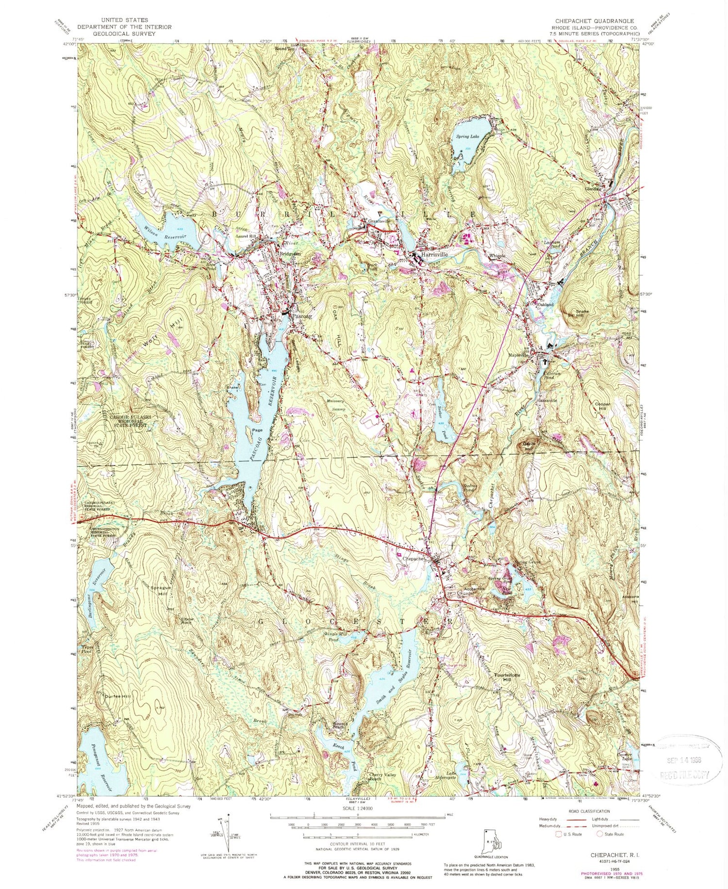
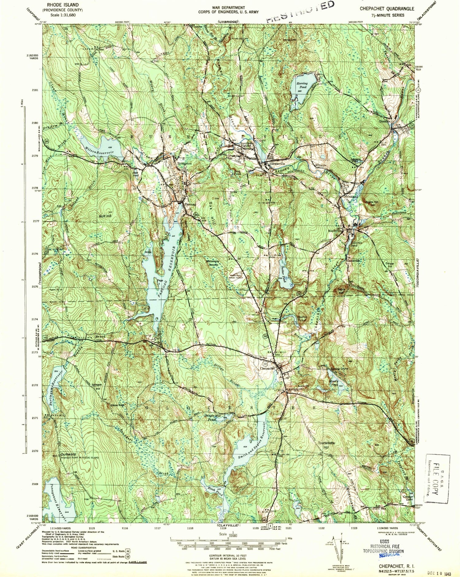
Classic USGS Chepachet Rhode Island 7.5'x7.5' Topo Map
Couldn't load pickup availability
Historical USGS topographic quad map of Chepachet in the states of Rhode Island, Massachusetts. Typical map scale is 1:24,000, but may vary for certain years, if available. Print size: 24" x 27"
This quadrangle is in the following counties: Providence.
The map contains contour lines, roads, rivers, towns, and lakes. Printed on high-quality waterproof paper with UV fade-resistant inks, and shipped rolled.
Contains the following named places: Mosquitohawk Brook, Whipple, Herring Brook, Harrisville, Duck Pond, Graniteville, Nipmuc River, Pascoag River, Bridgeton, Mowry Brook, Laurel Hill, Ross Pond, Wilson Reservoir, Leland Brook, Iron Mine Brook, Dry Arm Brook, Spring Lake, Tucker Brook, Garvy Ledges, Tepee Pond, Ponaganset Reservoir, Saunders Brook, Wescott Beach, Keech Pond, Cherry Valley Beach, Lake Aldersgate, Tourtellotte Hill, Smith and Sayles Reservoir, Shingle Mill Pond, Elbow Rock, Durfee Hill, Burlingame Reservoir, Sprague Hill, Stingo Brook, Chepachet, Acote Hill, New Pond, Spring Grove Pond, Cooper Hill, Gazza Hill, Sucker Brook, Steeres Pond, Sucker Pond, Malavary Swamp, Pascoag Reservoir, Page Island, Brandy Brook, Wolf Hill, Snake Island, Pascoag, Oak Hill, Mapleville, Gilleran Pond, Snake Hill, Oakland, Clear River, Lapham Pond, Coomer Lake Dam, Spring Grove Pond, Mower Pond Dam, Smith and Sayles Reservoir Dam, Burlingame Reservoir Upper Dam, Sucker Pond Dam, Pascoag Reservoir Upper Dam, Branch River, Oakland Pond Dam, Aldersgate Lake, Aldersgate Lake Dam, Harrisville Pond Dam, Wilson Reservoir Dam, Spring Lake Dam, Huntsville, Glendale, Round Top, Spring Grove, Gazzaville, Chepachet River, Town of Glocester, Town of Burrillville, Austin T Levy School, Berean Baptist Church, Burrillville High School, Burrillville Town Hall, Burrillville United Methodist Church, Calvary Episcopal Church, Chepachet Cemetery Acotes Hill, Chepachet Union Church, Community Christian School, Durfee Hill Management Area, Father Holland Catholic Regional Elementary School, First Universalist Church of Burrillville, Flynns Beach, Fogarty Memorial School, Gillerans Pond Beach, Glad Tidings Assembly of God Church, Glendale Post Office, Glocester Town Hall, Harrisville Historic District, Harrisville Mill Pond, Captain Benjamin Hawkins Lot Cemetery, Heritage Park, Irons - Steere Burying Ground, Mapleville Post Office, New Hope Baptist Church, Pascoag Community Baptist Church, Pascoag Post Office, Pascoag Public Library, Pascoag Race Track (historical), Ross Trail, Spring Lake Beach, Samuel Steere Lot, YWCA Beach, Harrisville Census Designated Place, Pascoag Census Designated Place, Glocester Town Pound (historical), Burrillville Police Department, Chepachet Barracks, Chepachet Fire Department, Glocester Manton Free Public Library, Glocester Police Dept, Harrisville Fire Department, Jesse M Smith Memorial Library, Oakland Mapleville Fire Department, Pascoag Fire Department Station 1, The Learning Place, Chepachet Post Office, Harrisville Post Office, Fogarty Memorial School, Harmony Hill School, Harrisville Preschool, Raggedy Ann and Andy Nursery School, Steere Farm Elementary School, William L Callahan School, Snowhurst Farms, Chepachet Census Designated Place, Pascoag Fire Department Station 2, Horton Island, Harrisville Cemetery, Reverend Moab Paine Lot, Pascoag Cemetery, Sayles - Eddy Lot, Mount Saint Charles Cemetery, Paine - Phillips - Sayles Lot, Zebede Williams Lot, Brown - Millard Lot, Harris - White - Darling Lot, Duty Smith Lot, John Mathewson Lot, Whipple Lot, Eddy - Aldrich Lot, Saint Patricks Cemetery, Marsh - Hopkins - Potter Cemetery, Elder William Bowen Lot, Hicks - Smith Lot, Cooper - Mowry Lot, Phetterplace Jones Lot, Silas Saunders Lot, Enoch Steere Lot, Doctor Nathaniel Sweet Lot, Esek Brown Lot, James Martin Lot, Phillips Lot Cemetery, Deacon Joshua Windsor Lot, Friends Lot, Ebenezer Darling Lot, George Bowen Lot, Willard Wade Lot, Hopkins - Angell Lot, Andrew Harris Lot, Cyrel Bowen Lot, Owen - Evans Lot, Taft Baker Lot, Sayles Cook Lot, Public Cemetery, Albee - Paine Lot, James Wilson Lot Cemetery, Israel Young Lot Cemetery, Cary - Ballou Lot, Othniel Young Lot Cemetery, Washington Logee Lot Cemetery, John White Lot Cemetery, Saint Patrick's Cemetery, Place - Keach Lot, Samuel Lee Lot Cemetery, Smith Paine Lot Cemetery, Frank Prouty Cemetery, Smith Aldrich Lot Cemetery, Chockalog River, Round Top Brook, Mosquitohawk Brook, Whipple, Herring Brook, Harrisville, Duck Pond, Graniteville, Nipmuc River, Pascoag River, Bridgeton, Mowry Brook, Laurel Hill, Ross Pond, Wilson Reservoir, Leland Brook, Iron Mine Brook, Dry Arm Brook, Spring Lake, Tucker Brook, Garvy Ledges, Tepee Pond, Ponaganset Reservoir, Saunders Brook, Wescott Beach, Keech Pond, Cherry Valley Beach, Lake Aldersgate, Tourtellotte Hill, Smith and Sayles Reservoir, Shingle Mill Pond, Elbow Rock, Durfee Hill, Burlingame Reservoir, Sprague Hill, Stingo Brook, Chepachet, Acote Hill, New Pond, Spring Grove Pond, Cooper Hill, Gazza Hill, Sucker Brook, Steeres Pond, Sucker Pond, Malavary Swamp, Pascoag Reservoir, Page Island, Brandy Brook


