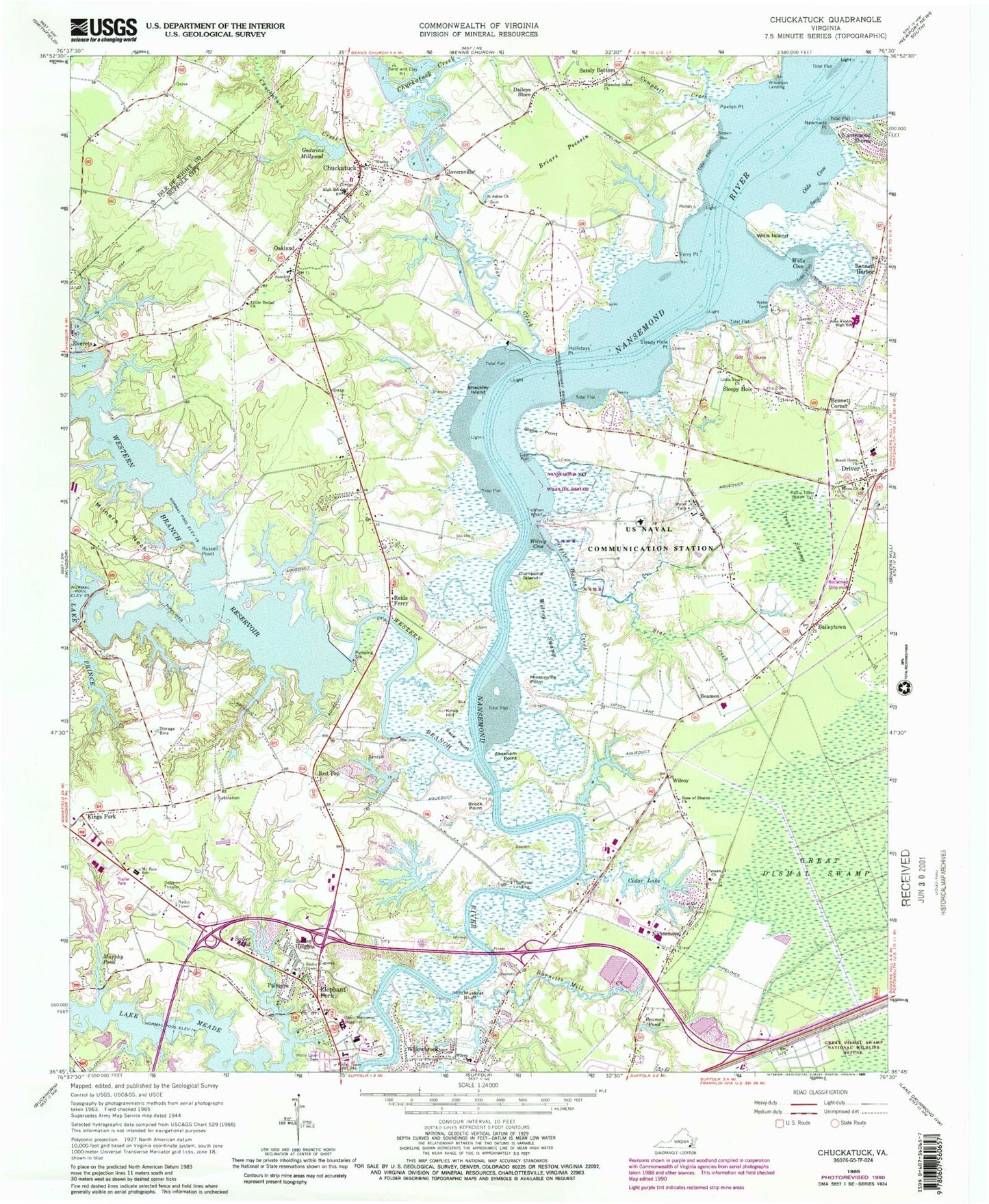
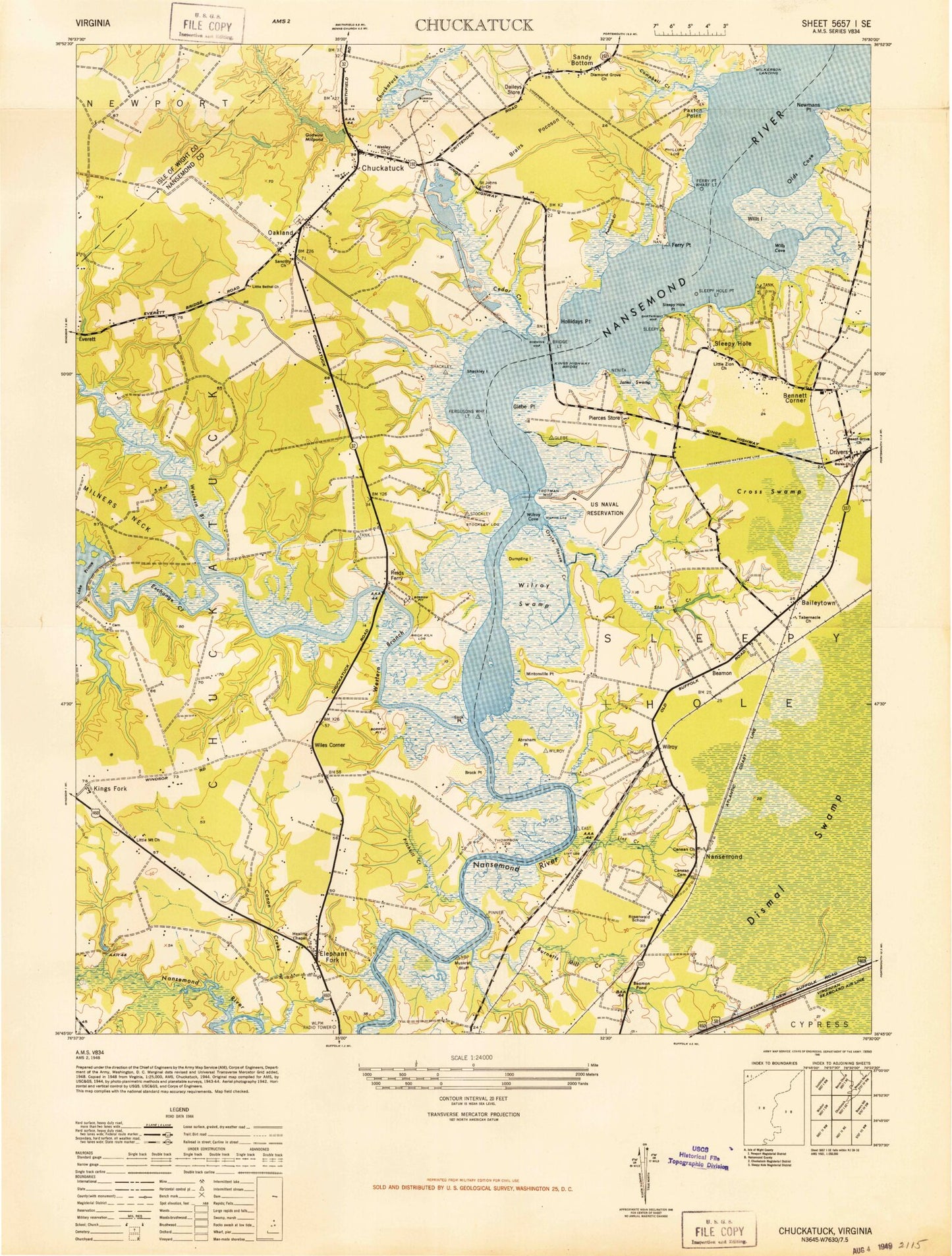
MyTopo
Classic USGS Chuckatuck Virginia 7.5'x7.5' Topo Map
Couldn't load pickup availability
Historical USGS topographic quad map of Chuckatuck in the state of Virginia. Map scale may vary for some years, but is generally around 1:24,000. Print size is approximately 24" x 27"
This quadrangle is in the following counties: Isle of Wight, Suffolk (city).
The map contains contour lines, roads, rivers, towns, and lakes. Printed on high-quality waterproof paper with UV fade-resistant inks, and shipped rolled.
Contains the following named places: Abraham Point, Autumn Care of Suffolk Nursing Home, Baileytown, Beamon, Beamon Pond, Beech Grove Church, Bennett Corner, Bennett Harbor, Berea Church, Berkshire Meadows, Bradys Marina, Briars Pocosin, Brick Kiln Landing, Bridge Point Farms, Brights Dam, Brittany Farms, Brock Point, Burnetts Mill Creek, Campbell Creek, Canaan Baptist Church Cemetery, Canaan Church, Cedar Creek, Cedar Lake, Cedar Lake Shores, Chuckatuck, Chuckatuck Post Office, Constances Warehouse, Cross Swamp, Daileys Store, Diamond Grove Church, Driver, Driver Elementary School, Driver Post Office, Dumpling Island, Elephant Fork, Elephant's Fork Elementary School, Fergusons Wharf Light, Ferry Point, Ferry Point Dam, Ferry Point Pond, Ferry Point Wharf, Ferry Point Wharf Light, Friendship Cathedral Worship Center, G Robert House Junior Water Treatment Facility, Glebe Point, Gloversville, Godwin Commerce Park, Godwin-Culpepper Dam, Godwins Millpond, Godwins Millpond Dam, Great Shoal, Greater New Hope Church of God in Christ, Healing Chapel, Hollidays Point, Holly Lawn Cemetery, Indian Point Estates, Issac Walton Dam, Issac Walton Lake, Janes Swamp, John Yeates Middle School, Kensington Square Shopping Center, King`s Fork High School, King`s Fork Middle School, Kings Crossing, Kings Fork, Kings Highway Bridge, Kings Point, Kingsdale, Knob Hill, Lake Forest, Lake Meade, Lake Meade Office Park, Lake Meade Point, Lake Prince Dam, Lake Prince Woods Assisted Living Facility, Lakeview Medical Center, Little Bethel Church, Little Mount Church, Little Zion Cemetery, Little Zion Church, Lone Star Lakes, Louise Obici Memorial Hospital Heliport, Mack Benn Jr Elementary School, Magnolia Lakes Mobile Home Park, Magnolia United Methodist Church, Milners Neck, Mintonville Point, Mount Zion Elementary School, Murphy Pond, Muskrat Bluff, Nansemond, Nansemond - Suffolk Academy, Nansemond National Wildlife Refuge, Nansemond Parkway Elementary School, Nansemond River Golf Club, Nansemond River High School, Newmans Point, North Gate, Oakland, Oakland Christian Church, Oakland Elementary School, Olds Cove, Open Door Church of Suffolk, Outlaw Mobile Home Park, Oyster House Creek, Palmyra, Paxton Point, Phillips Landing, Pierces Store, Point Harbor, Princeview Point, Red Top, Reids Ferry, Rivercliff, Rose of Sharon Church, Rosenwald School, Rountree North Dam, Rountree North Pond, Rountree South Dam, Rountree South Pond, Russel Point, Russell Point, Sack Point, Sadler Heights, Sadler Pond, Saint Johns Church, Sanctity Church, Sandy Bottom, Sentara Obici Hospital, Shackley Island, Sleepy Hole, Sleepy Hole Golf Course, Sleepy Hole Point, Sleepy Hole Point Light, Sleepy Point Estates, Southeastern Public Service Authority Regional Landfill, Star Creek, Stockley Landing, Suffolk Department of Fire and Rescue Station 10 Driver Volunteer Fire Department, Suffolk Department of Fire and Rescue Station 4, Suffolk Department of Fire and Rescue Station 6, Suffolk Department of Fire and Rescue Station 9 Chuckatuck Volunteer Fire Department, Suffolk Family YMCA, Suffolk Public Library System Chuckatuck Branch Library, Tabernacle Church, Thompson Landing, Trotman Wharf, WAVY-TV (Portsmouth), Wesley Church, Western Branch Dam, Western Branch Nansemond River, Western Branch Reservoir, Western Tidewater Regional Jail, WHRO-FM (Norfolk), WHRO-TV (Hampton-Norfolk), WHRV-FM (Norfolk), Wilkerson Landing, Willowbrook, Wills Cove, Wills Island, Wilroy, Wilroy Church, Wilroy Cove, Wilroy Industrial Park, Wilroy Swamp, WJCB-TV (Norfolk), WLPM-AM (Suffolk), WTVZ-TV (Norfolk)