MyTopo
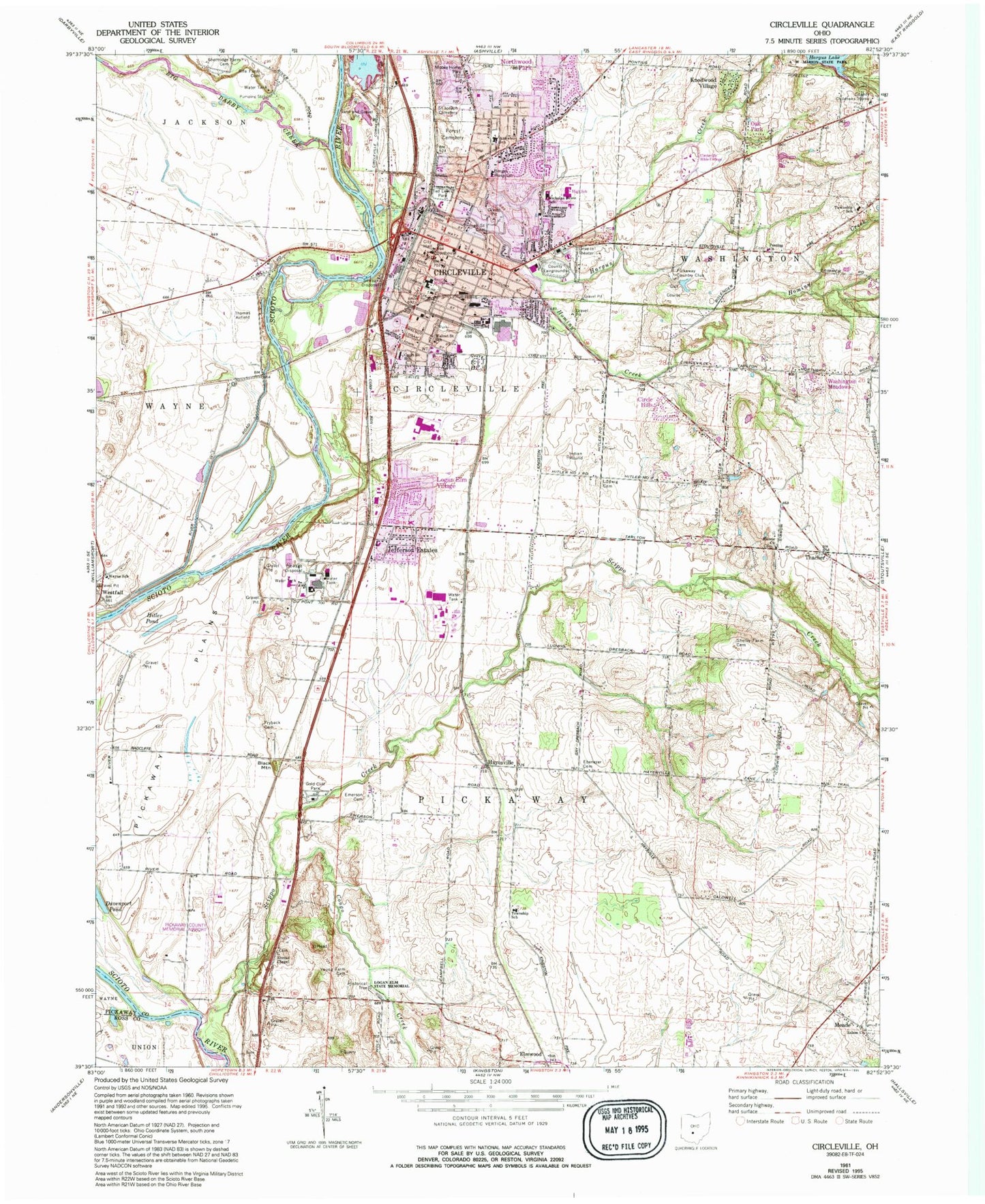
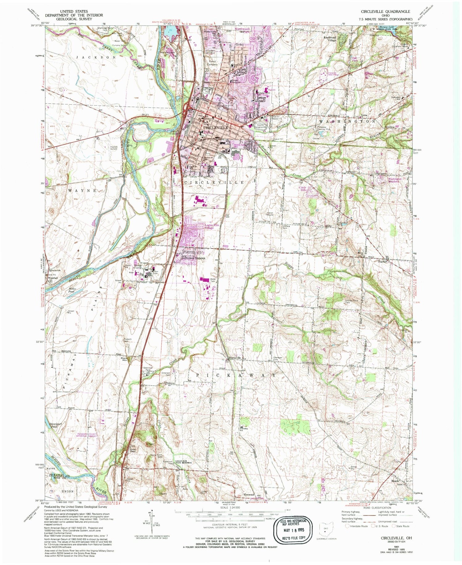
Classic USGS Circleville Ohio 7.5'x7.5' Topo Map
Couldn't load pickup availability
Historical USGS topographic quad map of Circleville in the state of Ohio. Map scale may vary for some years, but is generally around 1:24,000. Print size is approximately 24" x 27"
This quadrangle is in the following counties: Pickaway, Ross.
The map contains contour lines, roads, rivers, towns, and lakes. Printed on high-quality waterproof paper with UV fade-resistant inks, and shipped rolled.
Contains the following named places: Atwater Elementary School, Barnhart Farm, Berger Hospital, Big Darby Creek, Black Mountain, Boggs Farms, Boldoser Farms, Bowling Farms, Brookside Park, Brooks-Yates School, Burning Indian Mound, Calvary United Methodist Church, Campus Court, Church of Christ in Christian Union, Church of God, Church of the Brethren, Circle Hills, Circleville, Circleville Bible College, Circleville Carrier Unit Post Office, Circleville Fire and EMS Station 1, Circleville Fire Department and Emergency Medical Services Station 2, Circleville High School, Circleville Historic District, Circleville Hospital, Circleville Pit, Circleville Police Department, Circleville Post Office, City of Circleville, Community United Methodist Church, Congo Creek, Corwin Street School, Court Street Elementary School, Davenport Pond, Dels Trailer Park, Dorney, Earnhart School, Ebenezer Cemetery, Ebenezer School, Elmwood, Elsea Mobile Village, Emanuel United Methodist Church, Emerson Cemetery, Emmett School, Emmit Chapel, Emmitt Chapel Cemetery, Everts Middle School, First Church of the Nazarene, First Freewill Baptist Church, First Presbyterian Church, Forest Cemetery, Franklin School, Fryback Cemetery, Gold Cliff Park, Good Shepherd United Methodist Church, Graystone Villas, Hargus Creek, Hayesville, Heathergreen, High Street Cemetery, High Street School, Historical Tree, Hitler Ludwig Cemetery, Hitler Pond, Hominy Creek, Hooven, Jefferson Estates, Jefferson School, Knollwood Village, Lick Run, Liston Farms, Logan Elm State Memorial, Logan Elm Village, Logan Elm Village Census Designated Place, Ludwig School, Meade, Meade Cemetery, Meade Post Office, Memorial Hall, Miedema Dairy, Miller, Morris Church, Morris Mobile Village, Morris United Brethren Cemetery, Mound Street Elementary School, Mount of Praise Church of Christ in Christian Union, Mount Oval Farms, Nash Corners, Nicholas Drive Elementary School, Northwood Park, Oak Park, Owen School, Pickaway Country Club, Pickaway County Childrens Home, Pickaway County Courthouse, Pickaway County Fairgrounds, Pickaway County Law Library, Pickaway County Memorial Airport, Pickaway County Sheriff's Office, Pickaway Elementary School, Pickaway Plains, Pickaway Plains Ambulance Service, Pickaway Plains Commerical Park, Pickaway Township Fire Department, Pontious Chapel Cemetery, Pontius United Methodist Church, Rhoads Farm, Richards Farms, Rife Farm Cemetery, Rittinger Farm, Saint Joseph Cemetery, Saint Josephs Catholic Church, Saint Josephs School, Saint Philips Episcopal Church, Salem Church, School Number 5, School Number 6, Scippo Creek, Second Baptist Church, Shelby Farm Cemetery, Sheldon, Shortridge Farm Cemetery, Spunkeytown, Squawtown, Stout School, Ted Lewis Park, Thacher, Thatcher Post Office, Thomas Airport, Township of Circleville, Township of Pickaway, Township of Washington, Trinity Lutheran Christian Pre-School, Trinity Lutheran Church, Walnut Street School, Washington Elementary School, Washington Meadows, Washington Township School, Wayne School, Westfall, Westfall Cemetery, Young Farm Cemetery, ZIP Code: 43113