
MyTopo
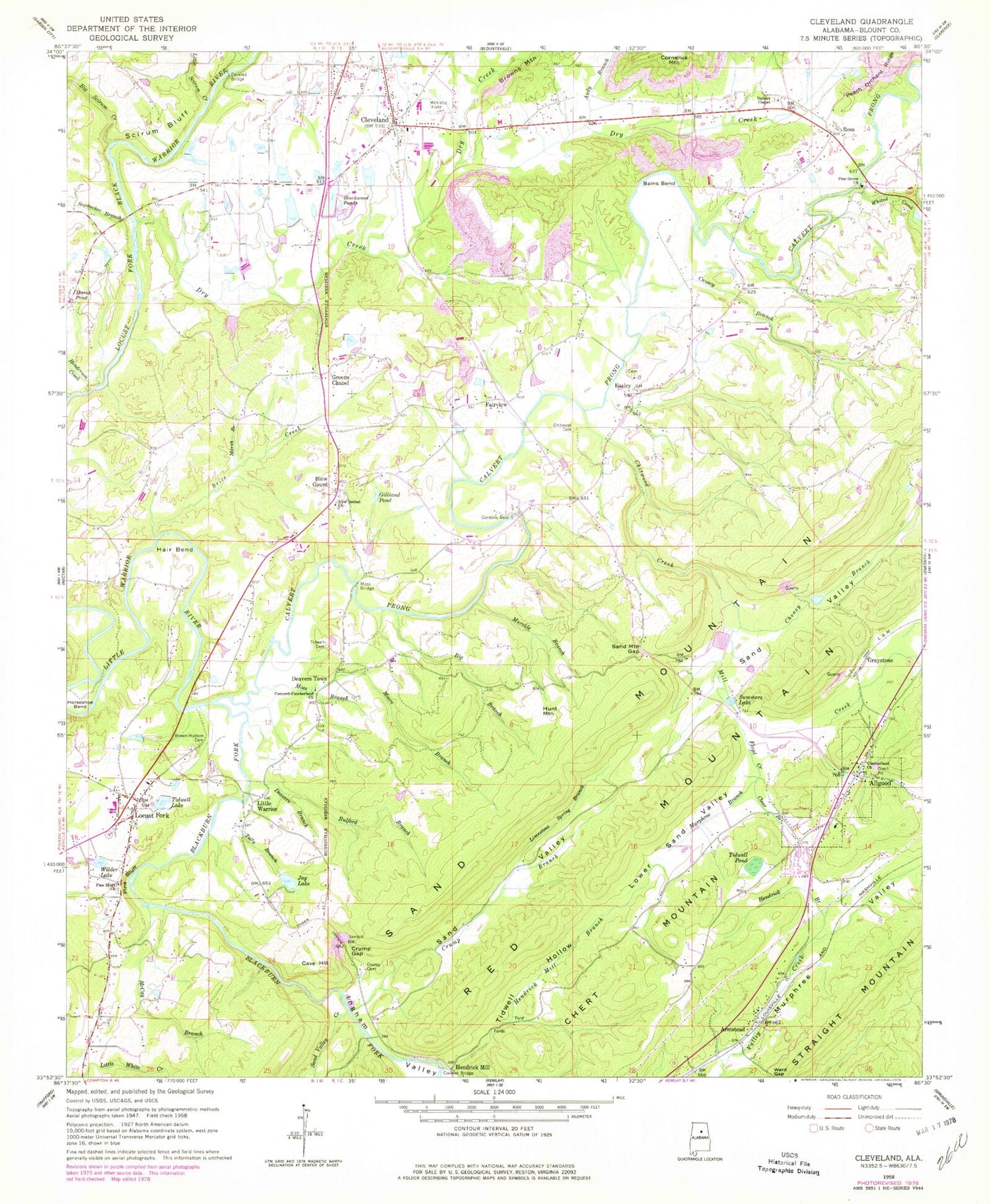
Classic USGS Cleveland Alabama 7.5'x7.5' Topo Map
Couldn't load pickup availability
Historical USGS topographic quad map of Cleveland in the state of Alabama. Map scale may vary for some years, but is generally around 1:24,000. Print size is approximately 24" x 27"
This quadrangle is in the following counties: Blount.
The map contains contour lines, roads, rivers, towns, and lakes. Printed on high-quality waterproof paper with UV fade-resistant inks, and shipped rolled.
Contains the following named places: Allgood, Allgood Cumberland Presbyterian Church, Allgood Post Office, Allgood School, Allgood Volunteer Fire Department, Andy Branch, Armstead, Armstead Church, Bains Bend, Big Branch, Big Scirum Creek, Blackburn Fork Little Warrior River, Blackwood Ponds, Blount County, Blow Gourd, Brice Creek, Brown-Hudson Cemetery, Browns Mountain, C H Head Lake Dam, Calvert Prong Little Warrior River, Causey Branch, Cave Hill, Cheney Branch, Chert Mountain, Chitwood Cemetery, Chitwood Creek, Clear Branch, Cleveland, Cleveland Division, Cleveland First Baptist Church, Cleveland High School, Cleveland Post Office, Cleveland United Methodist Church, Cleveland Volunteer Fire Department, Concord Cumberland Church, Cornelius Mountain, County Ford, Crump Branch, Crump Cemetery, Crump Gap, Daileys Chapel Cemetery, Daileys Chapel Methodist Church, Deavers Branch, Deavers Town, Doctor Pattons Lake Dam, Doctor Pattons Upper Lake, Dry Creek, Easley, Easley Church, Fairview, Fairview Church, Faith Chapel Church, Fauss Ford, Floyd Creek, Gilliand Pond, Gordons Dam, Graystone, Greens Chapel, Greens Chapel Cemetery, Greens Chapel Cumberland Presbyterian Church, Hair Bend, Hazerig Farm Lake, Hazerig Lake, Hazerig Lake Dam, Hazerig Lower Pond Dam, Hazerig Pond, Hazerig Small Pond, Hazerig Small Pond Dam, Hazerig Upper Pond, Hazerig Upper Pond Dam, Henderson Creek, Hendrick Branch, Hendrick Gap, Hendrick Mill, Hendrick Mill Branch, Horseshoe Bend, Hunt Mountain, Ingham Valley, Jay Lake, Limestone Spring Branch, Little Scirum Creek, Little Warrior, Little White Creek, Locust Fork, Locust Fork Fire and Rescue Department, Locust Fork High School, Locust Fork Post Office, Lower Sand Valley, Lynn Haven Dairy, Marsh Branch, Marsh Lake, Martin Ford, McCay Branch, Mill Creek, Moore Branch, Moss Branch, Moss Bridge, Murckle Branch, Murphree Branch, New Bethel Church, Old Easley Road Bridge, Oneonta Fire Department Station 13, Paul Marsh Dam, Peach Orchard Ridge, Pine Bluff, Pine Bluff Cemetery, Pine Bluff Church, Pine Grove Baptist Church, Rosa, Rosa Fire and Rescue, Rosa Methodist Church, Rulford Branch, Sand Mountain Gap, Sand Valley Creek, Sapsucker Branch, Scirum Bluff, Summers Lake, Swann Covered Bridge, Tally Branch, Tidwell Cemetery, Tidwell Hollow, Tidwell Lake, Tidwell Lake Dam, Tidwell Pond, Tom Robinette Dam, Tom Robinette Lake, Town of Allgood, Town of Cleveland, Town of Rosa, Trinity Church, Warrior Post Office, Whited Creek, Wilder Lake, Wilder Lake Dam, ZIP Codes: 35013, 35049


