MyTopo
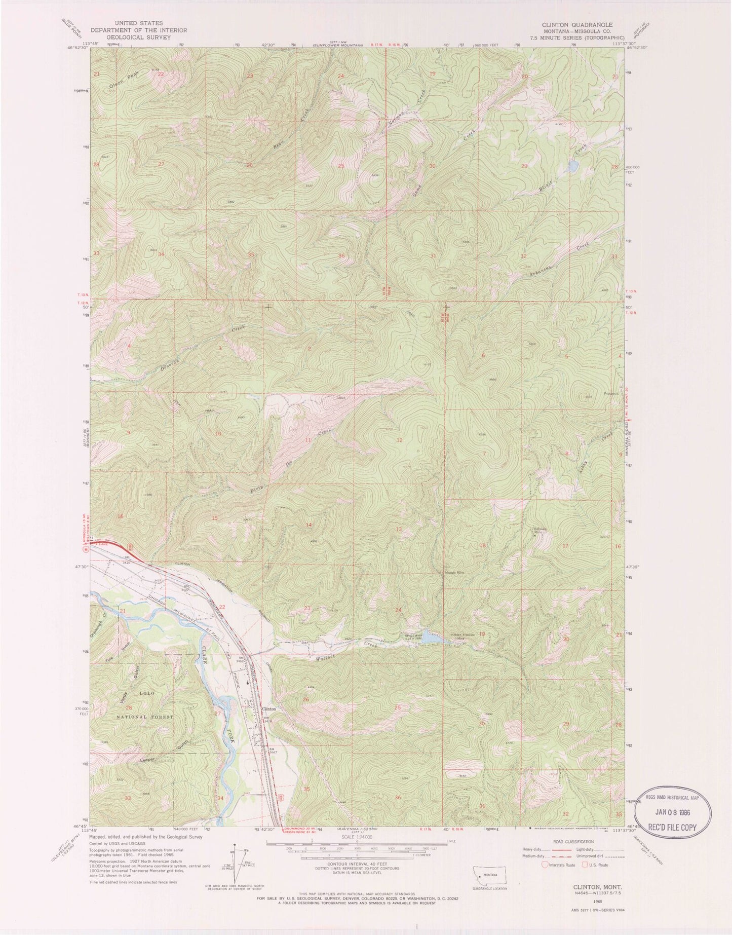
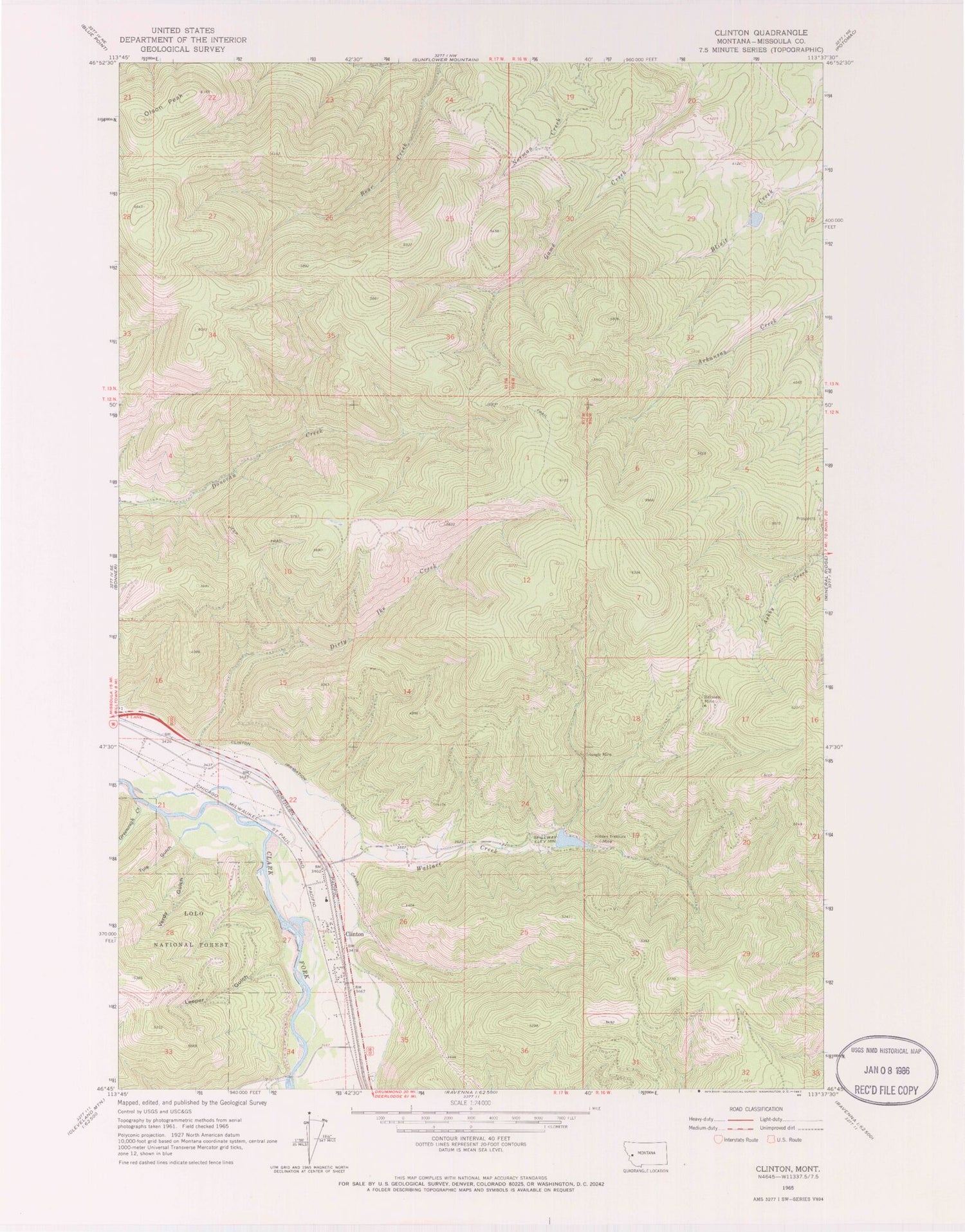
Classic USGS Clinton Montana 7.5'x7.5' Topo Map
Couldn't load pickup availability
Historical USGS topographic quad map of Clinton in the state of Montana. Map scale may vary for some years, but is generally around 1:24,000. Print size is approximately 24" x 27"
This quadrangle is in the following counties: Missoula.
The map contains contour lines, roads, rivers, towns, and lakes. Printed on high-quality waterproof paper with UV fade-resistant inks, and shipped rolled.
Contains the following named places: 12N17W16CDDD01 Well, 12N17W21AACB01 Well, 12N17W21ABBB01 Well, 12N17W22ACDB01 Well, 12N17W22ADDC01 Well, 12N17W22BBCC01 Well, 12N17W22BBDA01 Well, 12N17W22BCAD01 Well, 12N17W22BDCA01 Well, 12N17W22CADD01 Well, 12N17W22DAAB01 Well, 12N17W22DAAD01 Well, 12N17W22DACA01 Well, 12N17W22DBCB01 Well, 12N17W22DBCC01 Well, 12N17W23CCDB01 Well, 12N17W27AABB01 Well, 12N17W27AABC01 Well, 12N17W27AABC02 Well, 12N17W27AABD01 Well, 12N17W27AACA01 Well, 12N17W27AACA02 Well, 12N17W27AACB01 Well, 12N17W27AACD01 Well, 12N17W27ABAC01 Well, 12N17W27ADBA01 Well, 12N17W27ADCA01 Well, 12N17W27ADCD01 Well, 12N17W27ADDC01 Well, 12N17W27DAAB01 Well, 12N17W27DABA01 Well, 12N17W27DABA02 Well, 12N17W27DACA01 Well, 12N17W27DACA02 Well, 12N17W27DACD01 Well, 12N17W27DADB01 Well, 12N17W27DADC01 Well, 12N17W27DADD01 Well, 12N17W27DDAB01 Well, 12N17W27DDAB02 Well, 12N17W27DDAC01 Well, 12N17W27DDAC02 Well, 12N17W27DDAD01 Well, 12N17W27DDDA01 Well, 12N17W27DDDA02 Well, 12N17W27DDDA03 Well, 12N17W27DDDD01 Well, 12N17W34AAAD01 Well, 12N17W34AADC01 Well, 12N17W34CACD01 Well, 12N17W34DBCD01 Well, 12N17W34DBDD01 Well, 12N17W34DCAA01 Well, 12N17W34DDBA01 Well, 12N17W35BCCC01 Well, 12N17W35CBBB01 Well, 12N17W35CBBB02 Well, 12N17W35CBBC01 Well, 12N17W35CBCB01 Well, 12N17W35CBCC01 Well, Bellview Mine, Bellview/Silver Bell Mine, Betters Station, Blixit Creek Dam, Cape Nome Mine, Cascade Mine, Clinton, Clinton Census Designated Place, Clinton Elementary School, Clinton Irrigation District Canal, Clinton Post Office, Clinton Rural Fire District, Dirty Ike Creek, Greenough Creek, Hidden Treasure Mine, Jackpot Mine, Leeper Gulch, Martha Mine, McDonald/Sutherland Mine, North Point Mine, Olson Peak, Queen Mary Mine, Schwartz Creek Fishing Access Site, Swartz Creek, The Church of Jesus Christ of Latter Day Saints, Triangle Mine, Tule Gulch, Verdy Gulch, Wallace - Clinton School, Wallace Creek, Wallace Creek Dam, Wallace Creek Mill Mine