MyTopo
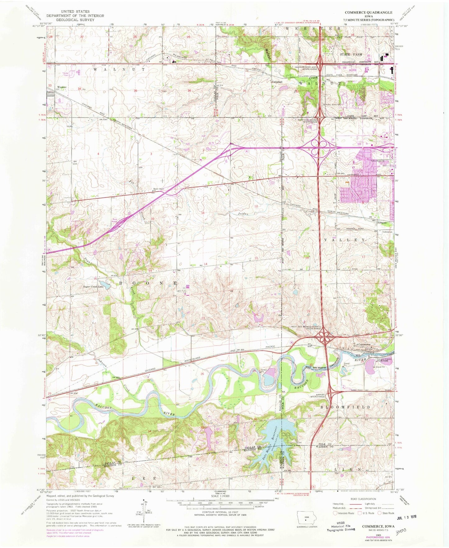
Classic USGS Commerce Iowa 7.5'x7.5' Topo Map
Couldn't load pickup availability
Historical USGS topographic quad map of Commerce in the state of Iowa. Map scale may vary for some years, but is generally around 1:24,000. Print size is approximately 24" x 27"
This quadrangle is in the following counties: Dallas, Madison, Polk, Warren.
The map contains contour lines, roads, rivers, towns, and lakes. Printed on high-quality waterproof paper with UV fade-resistant inks, and shipped rolled.
Contains the following named places: Ashawa, Ashawa Park, Ashawa Post Office, Ashworth Road Baptist Church, Beautiful Savior Lutheran Church, Brookview Elementary School, Campbell, Campbell Post Office, Campbell Recreation Area, Chautauqua Grounds, Children's Hospital Physicians Center, Christian Life Worship Center, Christs Church, City of Clive, City of Waukee, City of West Des Moines, Clive City Hall, Clive Public Library, Commerce, Commerce Community Church, Commerce Post Office, Crosspointe Church, Crossroads Park, Crossroads Park Elementary School, Dale Maffit Reservoir, Des Moines Golf and Country Club, Des Moines OBGYN Specialists, Eason Elementary School, Faith Lutheran Church, Fox Creek, Glen Oaks Country Club, Grace West Church, Hawkeye Care Center, Heartland Presbyterian Church, Hobbes Field, Huntington Ridge Park, Huston Cemetery, Immanuel Lutheran Church, Iowa Dermatology Clinic, Iowa Health Physicians Center, Iowa Heart Center, Iowa Orthopaedic Center, Jaycee Park, Johnson Creek, Jordan Creek Elementary School, Karp Park, Knolls Park, Korean Baptist Church, KWDM-FM (West Des Moines), Lake Country Club, Lakeview Family Practice Center, Living History Farms, Living History Farms Welcome Center, Maffit Cemetery, Maple Grove Church, Maple Grove Elementary School, Meadow View Park, Mercy West Family Clinic, Mercy West Pediatric Clinic, Mercy West Rehabilitation Center, Methodist Lutheran Physicians Center, Methodist West Hospital, Midwest Country Estates, Nordyk, Nordyke Post Office, Ponderosa Public Golf Course, Prairieview School, Reorganized Church of Jesus Christ of Latter Day Saints, Rio Valley Park, Saint Boniface Church, Saint Francis of Assisi Catholic School, Saint Francis of Assisi Church, Shepherd of the Valley Lutheran Church, Shepherds of the Valley Church, Southwood Park, Sugar Creek, Sugar Creek Lake, Sugar Creek Lake Dam, Township of Boone, Township of Walnut, University of Phoenix - Des Moines Campus, Valley Annex School, Valley Evangelical Free Church, Valley High School, Valley Southwoods Freshman High School, Valley United Methodist Church, Walnut Hills United Methodist Church, Walnut Ridge Park, Waukee City Police Department, Waukee East Bound Rest Area, Waukee Fire Department, Waukee High School, Waukee Middle School, Waukee West Bound Rest Area, Wellington Ridge Park, West Des Moines Calvary Baptist Church, West Des Moines Christian Church, West Des Moines Emergency Medical Service, West Des Moines Emergency Medical Services Station 18, West Des Moines Emergency Medical Services Station 19, West Des Moines Emergency Medical Services Station 21, West Des Moines Family Physicians Center, West Des Moines Fire Department Station 18, West Des Moines Fire Department Station 19, West Des Moines Fire Department Station 21, West Des Moines Fire Department Station 22, West Des Moines Library, West Des Moines Medical Clinic, West Des Moines Police Department, West Suburban Post Office, Western Hills Elementary School, Western Hills Park, Westridge Elementary School, Westview Church, Westwood Plaza, ZIP Codes: 50263, 50266, 50325