MyTopo
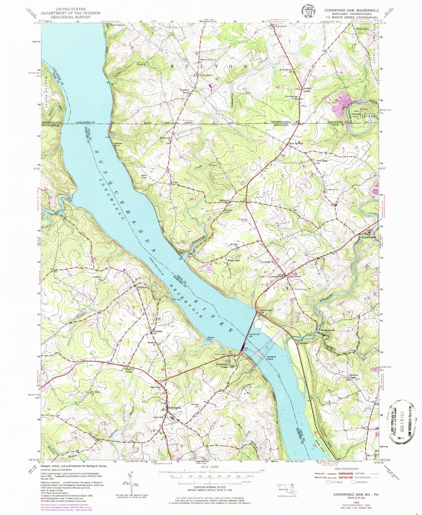
Classic USGS Conowingo Dam Maryland 7.5'x7.5' Topo Map
Couldn't load pickup availability
Historical USGS topographic quad map of Conowingo Dam in the states of Maryland, Pennsylvania. Typical map scale is 1:24,000, but may vary for certain years, if available. Print size: 24" x 27"
This quadrangle is in the following counties: Cecil, Chester, Harford, Lancaster, York.
The map contains contour lines, roads, rivers, towns, and lakes. Printed on high-quality waterproof paper with UV fade-resistant inks, and shipped rolled.
Contains the following named places: Berkley, Bethesda Cemetery, Broad Creek, Conowingo Church, Conowingo Creek, Conowingo Dam, Conowingo Reservoir, Conowingo Station, Darlington Cemetery, Deer Creek Harmony Presbyterian Church, Franklin Church, Glen Cove, Grace Church, Harmony Chapel, Hopkins Cove, Hosanna Church, Love Run, Mount Zoar Church, New Valley School, Oakwood, Octoraro Creek, Peddler Run, Pilot Station, Porters Grove Church, Rowland Island, Saint James Church, Saint Patricks Church, Sterret Island, Wildcat Point, Kilby Corner, Basin Run, Amos Falls, Bald Friar (historical), Bald Friar Ferry (historical), Camp Conowingo, Camp Shadowbrook, Cardiff, Conowingo (historical), Conowingo Baptist Church Cemetery, Conowingo Elementary School, Conowingo Manor, Cromleys Mountain, Five Points (historical), Granite Knoll Farms, Head of Canal (historical), Indian Rock (historical), Jacks Corner, Log Cabin School (historical), Long Island (historical), Mills Island (historical), Mount Pleasant (historical), Mount Zoar Cemetery, New Valley, Oakwood Rod and Gun Club, Persimmon Island (historical), Porter Bridge, Rawlings School House (historical), Red Hill Acres, Red Hill Estates, Rock, Rock Run Estates, Rough Island (historical), Rowlandsville Heights, Susquehanna Hills, Susquehanna State Park, The Bluffs, Topeka East, West Pilot Station, West Rock Station, Whispering Pines, Bald Friar, Castleton, Conowingo, Conowingo Village, Darlington, Hopkins Corner, Mount Zoar, Octoraro, Pilot, Richardsmere, Rock Springs, Rowlandsville, Octoraro Lakes Dam, Octoraro Lakes, Conowingo Airport (historical), Conowingo Post Office, Rocksprings Post Office (historical), Rowlandsville Post Office (historical), Conowingo Mobile Home Park, Broad Creek Landing, Broad Creek Park, Flintville (historical), Hickory Island (historical), Line Bridge Landing, Long Island (historical), Meadow Island (historical), Mutton Island (historical), Ross Island (historical), Stump Island (historical), Amos Island (historical), Bald Hill, Camp Ramblewood, Cedar Grove School (historical), Darlington Elementary School, Darlington Family Reading Center, Darlington Post Office, Darlington United Methodist Church, Darlington-Battle Swamp Historic District, Deer Creek Friends Meeting Cemetery, Dutch Island (historical), Emma Rockey Park, Francis Silver Park, Friends Meeting House (historical), Gallions Corner, Gladstone Acres, Glen Cove (historical), Halls Trailer Villa, Hosanna Cemetery, Lafayettes Crossing, Mason-Dixon Trail, Millers Store, Saint James Cemetery, Shures Landing, Sturgill, Old Conowingo Iron Bridge, District 8 Oakwood, Sleepy Hollow, Darlington Volunteer Fire Company Station 1, Water Witch Fire Company Station 73, Harford Friends School, Clearview Court, Darlington Mobile Home Park, Dublin Missionary Baptist Church, Octoraro Park, Community Fire Company of Rising Sun Station 28, Darlington Census Designated Place, Spring Fed Farm, Pembroke Farm Airport, Harford County Sheriff's Office Darlington Community Policing, Pilot Barrens, Camp Horseshoe, Coopers Cemetery, Haines Branch, Michael Run, Pleasant Grove, Pleasant Grove Church, Rock Springs Church, Rock Springs School, New Texas, Black Barren Spring, Black Baron, Jenkins Corner, Peters Creek Post Office (historical), New Texas Post Office (historical), Pleasant Grove Post Office (historical), Graywood Dairy Farm, Pleasant Grove Methodist Cemetery, Blake Cemetery, Rock Springs Baptist Church Cemetery, Rigby Cemetery, Berkley, Bethesda Cemetery, Broad Creek, Conowingo Church, Conowingo Creek, Conowingo Dam, Conowingo Reservoir, Conowingo Station, Darlington Cemetery, Deer Creek Harmony Presbyterian Church, Franklin Church, Glen Cove, Grace Church, Harmony Chapel, Hopkins Cove, Hosanna Church, Love Run, Mount Zoar Church, New Valley School, Oakwood, Octoraro Creek, Peddler Run, Pilot Station, Porters Grove Church, Rowland Island, Saint James Church, Saint Patricks Church, Sterret Island, Wildcat Point, Kilby Corner, Basin Run, Amos Falls, Bald Friar (historical), Bald Friar Ferry (historical), Camp Conowingo, Camp Shadowbrook, Cardiff, Conowingo (historical), Conowingo Baptist Church Cemetery, Conowingo Elementary School, Conowingo Manor, Cromleys Mountain, Five Points (historical), Granite Knoll Farms, Head of Canal (historical), Indian Rock (historical), Jacks Corner, Log Cabin School (historical), Long Island (historical), Mills Island (historical), Mount Pleasant (historical), Mount Zoar Cemetery, New Valley, Oakwood Rod and Gun Club, Persimmon Island (historical), Porter Bridge, Rawlings School House (historical), Red Hill Acres, Red Hill Estates, Rock, Rock Run Estates, Rough Island (historical), Rowlandsville Heights, Susquehanna Hills, Susquehanna State Park, The Bluffs, Topeka East, West Pilot Station, West Rock Station, Whispering Pines, Bald Friar, Castleton, Conowingo, Conowingo Village, Darlington, Hopkins Corner