
MyTopo
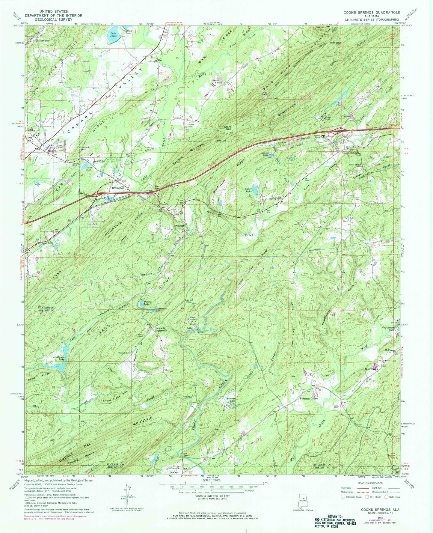
Classic USGS Cooks Springs Alabama 7.5'x7.5' Topo Map
Couldn't load pickup availability
Historical USGS topographic quad map of Cooks Springs in the state of Alabama. Map scale may vary for some years, but is generally around 1:24,000. Print size is approximately 24" x 27"
This quadrangle is in the following counties: Shelby, St. Clair.
The map contains contour lines, roads, rivers, towns, and lakes. Printed on high-quality waterproof paper with UV fade-resistant inks, and shipped rolled.
Contains the following named places: Acmar, Acmar Church, Acmar Elementary School, Acmar Post Office, Bald Rock Mountain, Baptist Camp, Baptist Camp Lake, Baptist Home, Baptist Lake Dam, Bethel Baptist Church, Birmingham Saw Works Lake Dam, Brompton, Browns Lake, Camp Winnataska, Cane Creek, Catfish Lake, Catfish Lake Dam, City of Moody, Cook Springs Baptist Church, Cook Springs Volunteer Fire Department, Cooks Springs, Cooks Springs Post Office, Cooks Springs Tunnel, Corbetts Lake, Double Branch, Double Oak Mountain, Dykes Mill, Franklin School, Hale Hollow, Halls Dam, Halls Lake, Hames Dam, Hames Lake, Happy Home Church, Head Springs, Hearthstone Creek, Hillhouse Lake, Hollis Cemetery, Hoover Dam, Hoover Lake, Hopewell Methodist Church, Hurst Hill, Jess Branch, Jess Hollow, Joyce Dam, Karr Gap, Karr Mountain, Kerr Branch, Lake Joyce, Lawley, Lawleys Chapel Cemetery, Lawleys Chapel United Methodist Church, Lee Branch, Little Creek, Luker Dam, Luker Lake, Monte Bello Estates, Moody, Moody Cemetery, Moody Division, Moody Fire and Rescue Department, Moody High School, Moody Junior High School, Moody Tabernacle, Moodys School, Moore Field, Mount Pleasant Church, NEW-AM (Moody), Patterson Branch, Pea Vine Ridge, Pleasant Grove, Poplar Grove School, Prescott, Prescott Church, Purvis Dam, Purvis Lake, Ram Horn Branch, Roaring Hollow, Saint Clair Forest, Saint Clair Nursing Home, Schneider Dam, Schneider Lake, Seventh Day Adventist Junior Academy, Shoal Creek, Shoal Creek Mountain, Spring Valley Estates, Stewarts Cemetery, Stewarts Crossroads, Stewarts Crossroads Church, Stewarts Crossroads Community Church, Stragglers Point, Suck Gap, Taylors Church, Taylors Gap, Taylors Mountain, Taylorsburg, The Church of the Valley, Tunnel Hill, Turtle Rock, Twin Lake Estates, Valleyhaven, Wolf Creek, Wolf Pen Ridge, Zion Church, ZIP Codes: 35004, 35052