


MyTopo
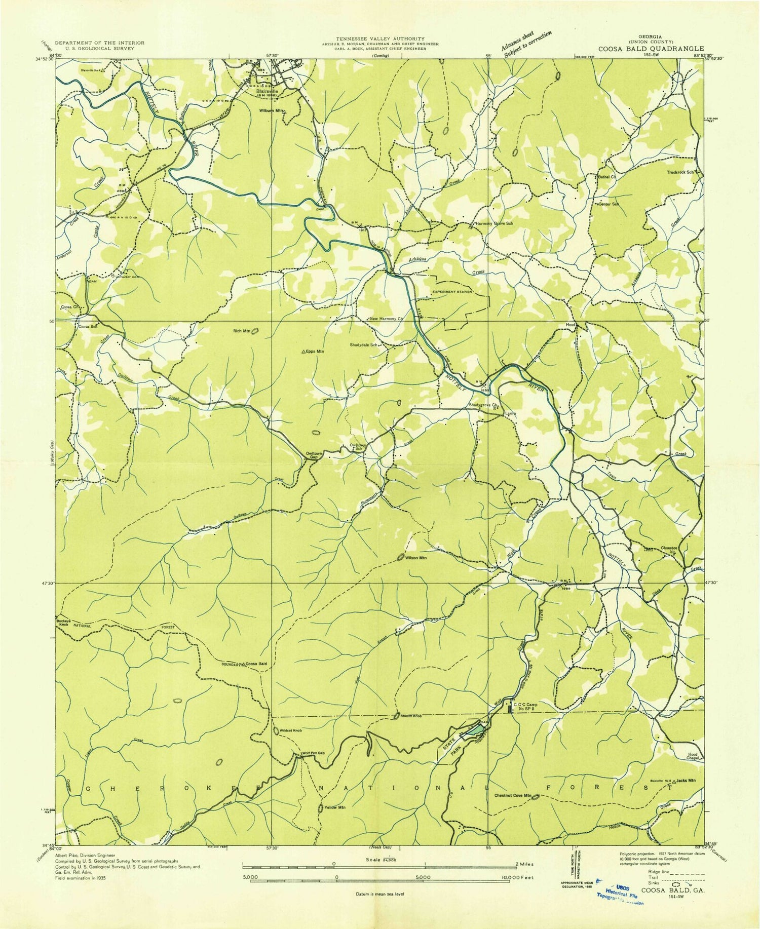
USGS Classic Coosa Bald Georgia 7.5'x7.5' Topo Map
Couldn't load pickup availability
Historical USGS topographic quad map of Coosa Bald in the state of Georgia. Scale: 1:24000. Print size: 24" x 27"
This quadrangle is in the following counties: Union.
The map contains contour lines, roads, rivers, towns, lakes, and grids including latitude / longitude and UTM / MGRS. Printed on high-quality waterproof paper with UV fade-resistant inks.
Contains the following named places: Akins Creek, Allison Branch, Allison Ridge, Anderson Creek, Arkaqua Creek, Big Branch, Board Camp Creek, Bony Branch, Bowers Cove, Bridge Gap, Buckeye Knob, Bull Gap, Burnett Branch, Burnett Gap, Butternut Creek, Calf Stomp Gap, Chestnut Cove, Chestnut Cove Gap, Cindy Cove, Cob Ridge, Cooks Cove Branch, Coosa Bald, Crawley Gap, Davis Ridge, Duncan Cemetery, Duncan Ridge, East Fork Coosa Creek, Epps Mountain, Fields Branch, Fortenberry Creek, Frady Branch, Garrett Creek, Gillespie Branch, Goober Gap, Hatchet Creek, Henson Cemetery, Hogpen Branch, Hospital Cove, Jones Branch, Jones Gap, Lake Trahlyta, Lance Branch, Lark Gap, Lawrence Branch, Little Bald, Little Duncan Ridge, Locust Stake Gap, Logan Creek, Calf Stump Branch, Long Branch, Long Ridge, Mathis Cemetery, Miller Cove, Miller Cove Branch, Morgan Branch, Morgan Bridge, Nance Payne Cove, Nelson Cove, Nelson Ridge, New Harmony Church, New Hope Church, Grace Calvary Mission, Nicholson Bridge, Old Liberty Church, Owl Hollow, Owltown Gap, Pine Ridge, Pineflat Gap, Reece Bridge, Rich Cemetery, Rich Gap, Rich Ridge, Roaring Fork, Salem Cemetery, Shady Grove Church, Sosebee Cove, Spiva Branch, Stewart Cove, Stewart Creek, Stink Creek, Tigue Branch, Tigue Gap, Town Creek, Town Mountain, Trackrock Branch, West Fork Coosa Creek, West Fork Wolf Creek, Whiteoak Stomp, Wildcat Branch, Wildcat Gap, Wilson Branch, Wolf Creek, Wolfpen Gap, Yellow Mountain Gap, Yellowhammer Gap, Yellowjacket Gap, Butt Cemetery, Helton Creek Falls, Sasebee Cove Scenic Area, Coosa Backcountry Trail, Ben Knob, Big Grassy Knob, Bowers Mountain, Choestoe, Crawley Mountain, Fisher Knob, Fort Mountain, Frady Mountain, Garland Knob, Jacks Mountain, Little Grassy Knob, Middle Bald, Owltown, Picketts Knob, Rich Knob, Salem Top, Scruggs Top, Self Mountain, Sheriff Knob, Wellborn Mountain, Wildcat Knob, Wilson Mountain, Yellow Mountain, Lake Trahlyta Dam, Caldwell Lake Dam, Caldwell Lake, Blairsville Airport, Berry School (historical), Bethel Cemetery, Blairsville Baptist Church, Blairsville Cemetery, Blairsville Methodist Church, Center School (historical), Choestoe Baptist Church, Choestoe Cemetery, Choestoe School (historical), Coosa Cemetery, Coosa School (historical), Fairview School (historical), Faith Church, Harmony Grove Cemetery, Harmony Grove School (historical), Laura (historical), New Harmony Cemetery, Old Liberty Cemetery, Old Liberty School (historical), Owltown Cemetery, Owltown Cemetery, Shady Grove Cemetery, Shady Grove School (historical), Shadydale School (historical), Track Rock School (historical), Trackrock Cemetery, Union County, Coosa Creek, Bethel Church, Chestnut Knob, Cooks Cove, Coosa Church, Fairview Church, Georgia Mountain Experiment Station, Harmony Grove Church, Caldwell (historical), Hood (historical), Otto (historical), Blairsville Division, Blairsville-Suches Division (historical), Blairsville Quarry, Union County Fire Department Station 1, Union County Fire Department Station 3, Union County Fire Department Station 12, Union County Fire Department Station 10, Union County Sheriff's Office, Blue Ridge Ranger District, Union County Jail


