MyTopo
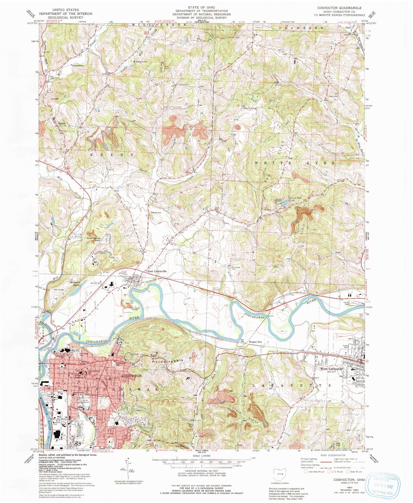
Classic USGS Coshocton Ohio 7.5'x7.5' Topo Map
Couldn't load pickup availability
Historical USGS topographic quad map of Coshocton in the state of Ohio. Map scale may vary for some years, but is generally around 1:24,000. Print size is approximately 24" x 27"
This quadrangle is in the following counties: Coshocton.
The map contains contour lines, roads, rivers, towns, and lakes. Printed on high-quality waterproof paper with UV fade-resistant inks, and shipped rolled.
Contains the following named places: Amity Cemetery, Baptist Cemetery, Burt Avenue Wesleyan Church, Calvary Baptist Church, Calvary United Methodist Church, Canal Lewisville, Canal Lewisville Cemetery, Canal Lewisville Census Designated Place, Canal Lewisville Post Office, Canal Lewisville United Methodist Church, Caton Cemetery, Central Christian Church, Central High School, Chestnut School, Chestnut Trailer Court, Chili, Chili Cemetery, Chili Methodist Church, Chili Post Office, Church of Christ, City of Coshocton, Clover Trailer Park, Coshocton, Coshocton Alliance Church, Coshocton Bible Holiness Church, Coshocton Christian School, Coshocton Christian Tabernacle, Coshocton Church of the Nazarene, Coshocton County Courthouse, Coshocton County Emergency Medical Services, Coshocton County Fairgrounds, Coshocton County Infirmary, Coshocton County Jail, Coshocton County Memorial Hospital, Coshocton County Sheriff's Office, Coshocton Fire Department, Coshocton High School, Coshocton Hospital, Coshocton Post Office, Coshocton Presbyterian Church, Coshocton Town and Country Club, Coshocton Water Works, Downtown Mobile Village, Downtowner Plaza Shopping Center, Emmanuel Evangelical Lutheran Church, Fairview Manor, First Baptist Church of Coshocton, First Baptist Church of West Lafayette, First Christian Baptist Church, First Church of Christ, First Church of Christ Scientist, Forest Hill Lake, Frocks Run, Grace United Methodist Church, H and W Mobile Home Park, Hardscrabble, Hardscrabble Hill, Hardscrabble School, Hill Cemetery, Hilltop Golf Course, Keene, Keene Elementary School, Keene Methodist Cemetery, Keene Post Office, Keene Presbyterian Cemetery, Kingdom Hall of Jehovahs Witnesses, Lake Park, Lincoln Elementary School, Little Mill Creek, Memory Garden Cemetery, Middle Basin, Morgan Run, Mudport Basin, Munnsville Post Office, Munsville, Nellie Chapel United Methodist Church, North Appalachian Experimental Watershed, Oak Grove Cemetery, Oak Ridge Cemetery, Park United Methodist Church, Pomerene Center for the Arts, Reamer Cemetery, Richard Downing Airport, Ridgewood High School, River Run Centre Shopping Center, Riverview Estates, Sacred Heart Catholic Church, Sacred Heart School, Saint Johns United Church of Christ, Saint Pauls Episcopal Church, School Number 1, School Number 2, School Number 3, School Number 4, School Number 7, School Number 8, Shiloh Missionary Baptist Church, South Lawn Cemetery, South Lawn Elementary School, Spoon Creek, Stewart Field, Sycamore School, Three Rivers Fire District Station 1, Township of Keene, Township of Lafayette, Township of Tuscarawas, Township of White Eyes, Trailer Estates, Trinity Episcopal Church, Turkey Run, Tuscarawas River, United States Hydrologic Experiment Station, Victory Baptist Christian School, Victory Baptist Church, Victory Center Pentecostal Church, Village of West Lafayette, Walhonding River, Washington Elementary School, West Lafayette, West Lafayette Elementary School, West Lafayette Police Department, West Lafayette Post Office, West Lafayette United Methodist Church, White Eyes Cemetery, WTNS-AM (Coshocton), WTNS-FM (Coshocton), ZIP Code: 43824