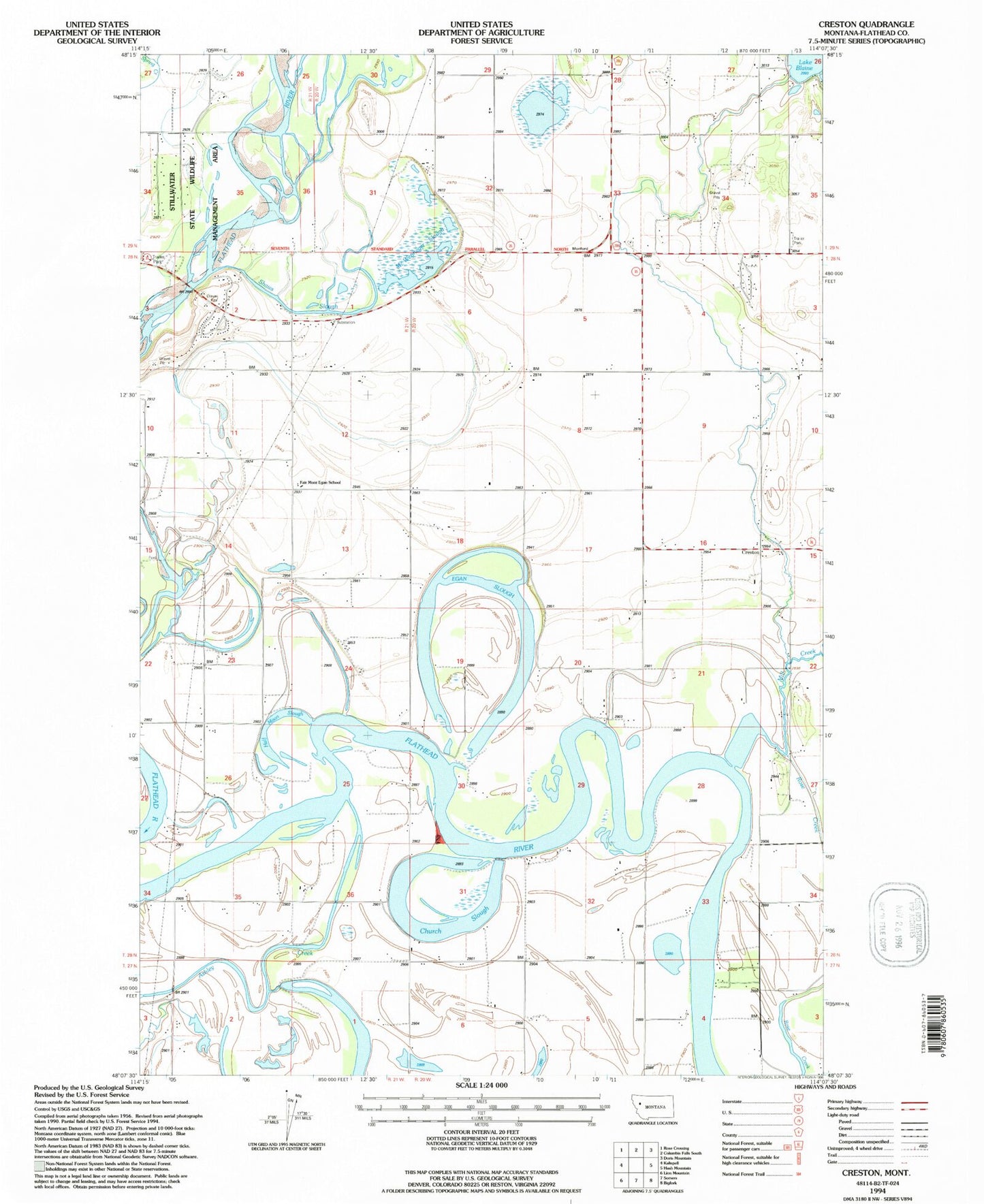
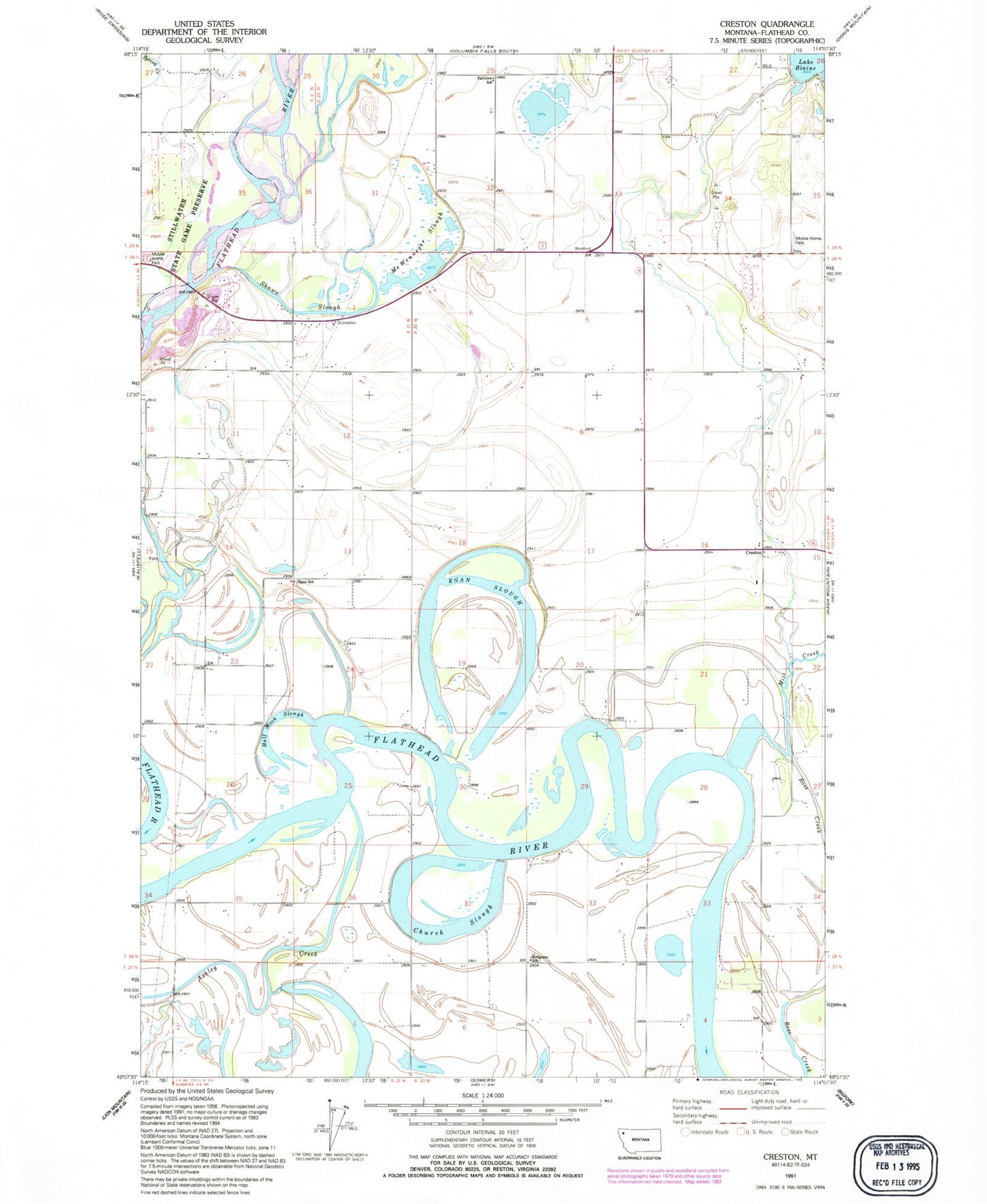
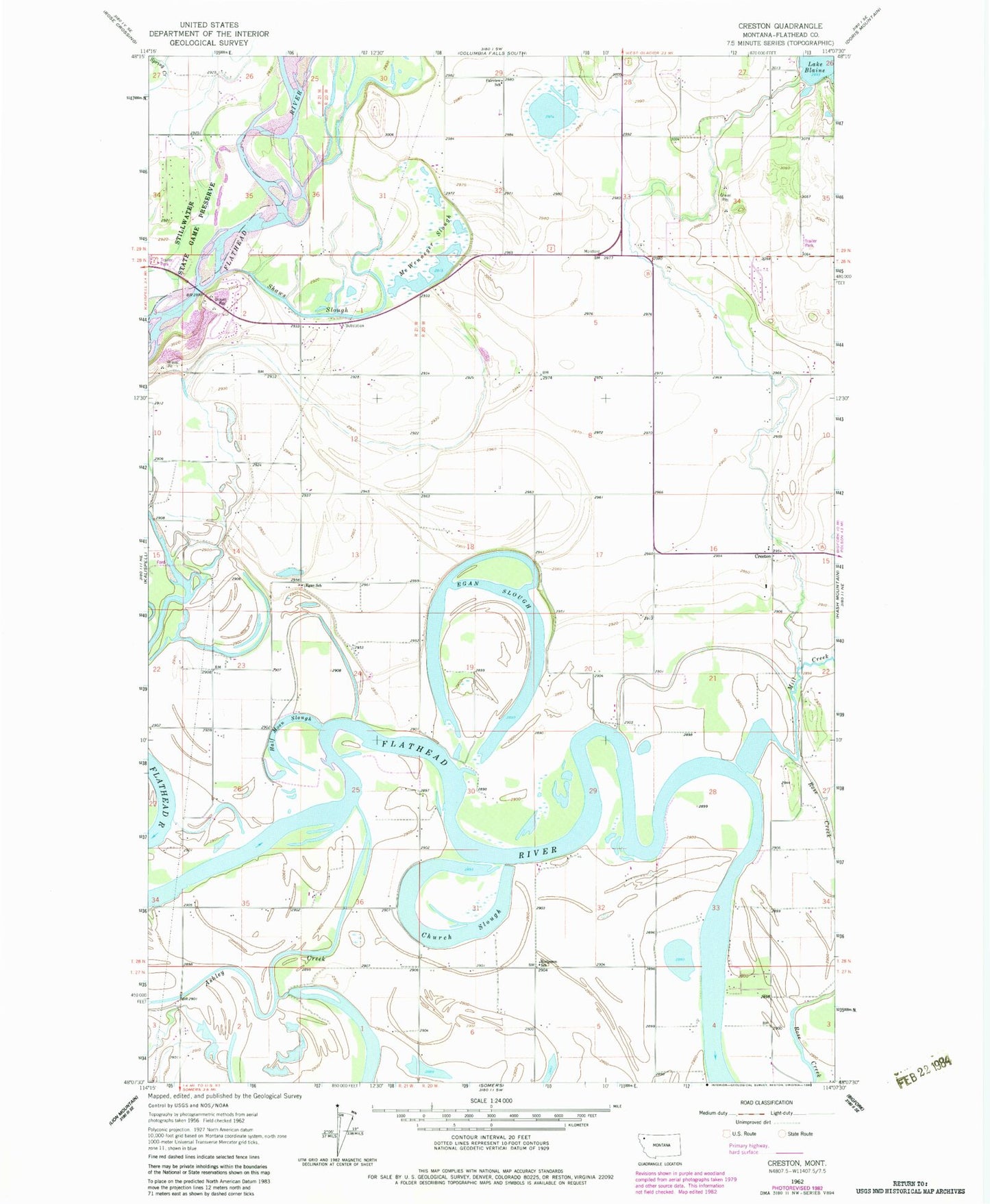
MyTopo
Classic USGS Creston Montana 7.5'x7.5' Topo Map
Couldn't load pickup availability
Historical USGS topographic quad map of Creston in the state of Montana. Map scale may vary for some years, but is generally around 1:24,000. Print size is approximately 24" x 27"
This quadrangle is in the following counties: Flathead.
The map contains contour lines, roads, rivers, towns, and lakes. Printed on high-quality waterproof paper with UV fade-resistant inks, and shipped rolled.
Contains the following named places: 27N20W03CD__01 Well, 27N20W04AAAA01 Well, 27N20W04DD__01 Well, 27N20W05AA__01 Well, 27N20W05AB__01 Well, 27N20W05BB__01 Well, 27N20W05DA__01 Well, 27N20W05DD__01 Well, 27N20W06AB__01 Well, 27N20W06AC__01 Well, 27N20W06AC__02 Well, 27N20W06BB__01 Well, 27N21W01BA__01 Well, 27N21W01DD__01 Well, 27N21W03DA__01 Well, 28N20W03BB__01 Well, 28N20W03CD__01 Well, 28N20W03CD__02 Well, 28N20W04AB__01 Well, 28N20W04BB__01 Well, 28N20W05DC__01 Well, 28N20W06BA__01 Well, 28N20W06BC__01 Well, 28N20W06DD__01 Well, 28N20W07AA__01 Well, 28N20W07DC__01 Well, 28N20W08AD__01 Well, 28N20W08BB__01 Well, 28N20W08CD__01 Well, 28N20W08DA__01 Well, 28N20W09AA__01 Well, 28N20W09BB__01 Well, 28N20W09DBBC01 Well, 28N20W09DDDA01 Well, 28N20W10BC__01 Well, 28N20W15BC__01 Well, 28N20W15BD__01 Well, 28N20W15CB__01 Well, 28N20W15CB__02 Well, 28N20W15CB__03 Well, 28N20W15CB__04 Well, 28N20W15CBD_01 Well, 28N20W15CBD_02 Well, 28N20W16AA__01 Well, 28N20W16AA__02 Well, 28N20W16AD__01 Well, 28N20W16CAAA01 Well, 28N20W16CC__01 Well, 28N20W16DD__01 Well, 28N20W18BD__01 Well, 28N20W18BD__02 Well, 28N20W18CC__01 Well, 28N20W20CB__01 Well, 28N20W20DC__01 Well, 28N20W22BC__01 Well, 28N20W30DB__01 Well, 28N20W31AD__01 Well, 28N20W32DA__01 Well, 28N20W34BB__01 Well, 28N20W34CA__01 Well, 28N20W34CC__01 Well, 28N21W01CA__01 Well, 28N21W01CB__01 Well, 28N21W01CB__02 Well, 28N21W01CB__03 Well, 28N21W01DD__01 Well, 28N21W02AD__01 Well, 28N21W02ADDC01 Well, 28N21W02BDCC01 Well, 28N21W02CA__01 Well, 28N21W02CD__01 Well, 28N21W02CD__02 Well, 28N21W02DD__01 Well, 28N21W11BAAA01 Well, 28N21W11CB__01 Well, 28N21W11CB__02 Well, 28N21W11DB__01 Well, 28N21W12AB__01 Well, 28N21W12AC__01 Well, 28N21W12CB__01 Well, 28N21W12CCCC01 Well, 28N21W12DA__01 Well, 28N21W13AB__01 Well, 28N21W13AD__01 Well, 28N21W13BABB01 Well, 28N21W13CA__01 Well, 28N21W13CC__01 Well, 28N21W14DD__01 Well, 28N21W15AA__01 Well, 28N21W15DA__01 Well, 28N21W23CA__01 Well, 28N21W23DA__01 Well, 28N21W26BABA01 Well, 28N21W35BC__01 Well, 28N21W35BCCD01 Well, 28N21W35CB__01 Well, 28N21W35CC__01 Well, 28N21W36DD__01 Well, 29N20W27BB__01 Well, 29N20W27CBBB01 Well, 29N20W27DA__01 Well, 29N20W28BD__01 Well, 29N20W28CA__01 Well, 29N20W29AC__01 Well, 29N20W29AC__02 Well, 29N20W29ACCD01 Well, 29N20W29BD__01 Well, 29N20W29CD__01 Well, 29N20W30DA__01 Well, 29N20W31ABCA01 Well, 29N20W31AD__01 Well, 29N20W32ADCD01 Well, 29N20W32BD__01 Well, 29N20W32BD__02 Well, 29N20W32DD__01 Well, 29N20W33CA__01 Well, 29N20W33CADC01 Well, 29N20W33CD__01 Well, 29N20W33DC__01 Well, 29N20W35CD__01 Well, 29N21W35BB__01 Well, 29N21W36DD__01 Well, Ashley Creek, Ashley Creek Bridge, Church Slough, Creston, Creston Fire Department, Creston Fire Department - Fairmont Station, Creston Fire Department Lake Blaine Station, Creston Post Office, Creston School, Egan Post Office, Egan School, Egan Slough, Fair - Mont - Egan School, Fairview School, Foster Mobile Home Park, Half Moon Slough, Hodgeson School, Jessup, Jessup Post Office, McWenneger Slough, Mill Creek, Montford Post Office, Montford School, Mountain Crossroads Golf Course, Patrick Creek, Ramsdell Post, Reeds Slough, Sanders Airport, Shaws Slough, Sheldon Post Office, Weaver Airport, Wounded Buck Ranch Airport