
MyTopo
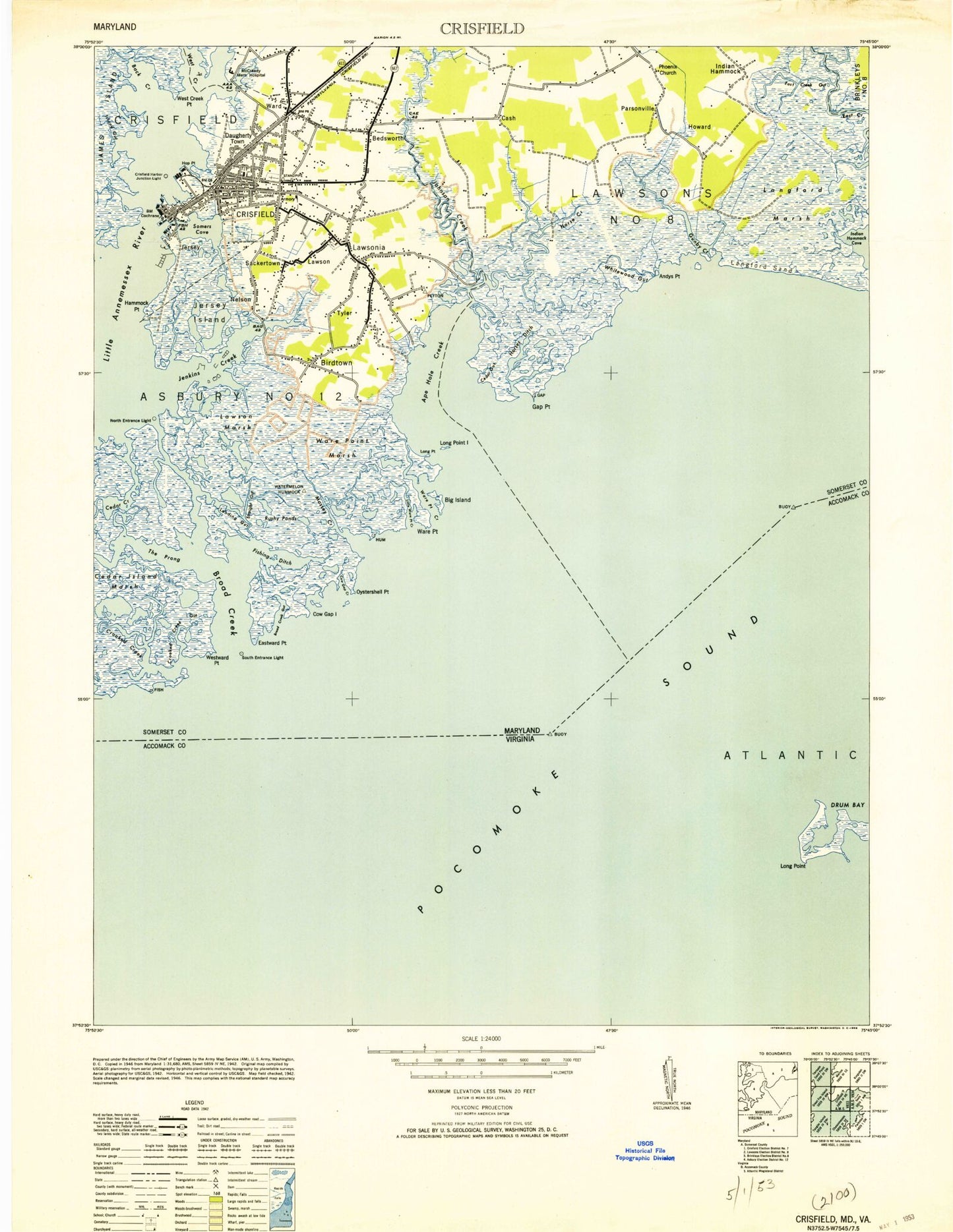
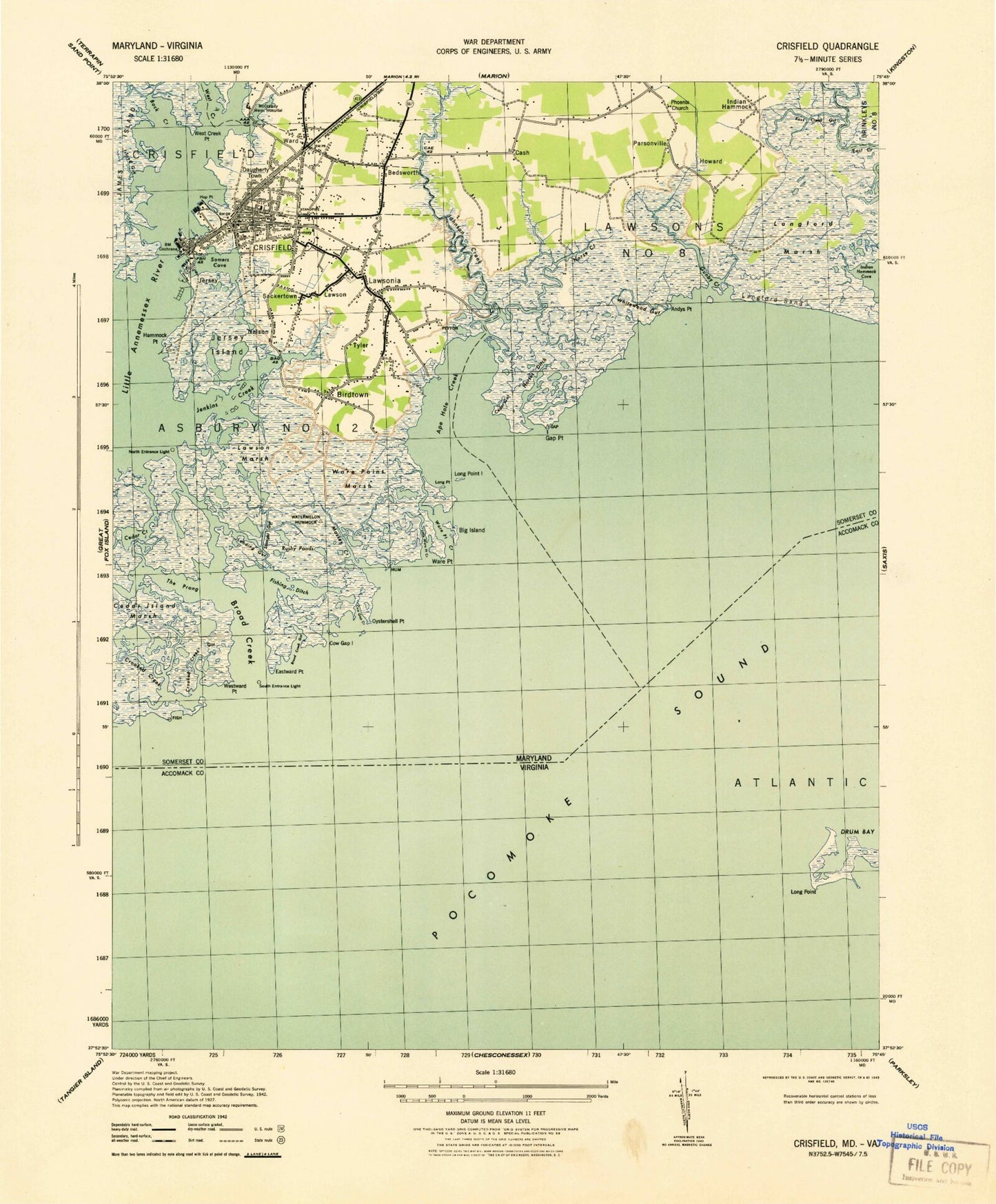
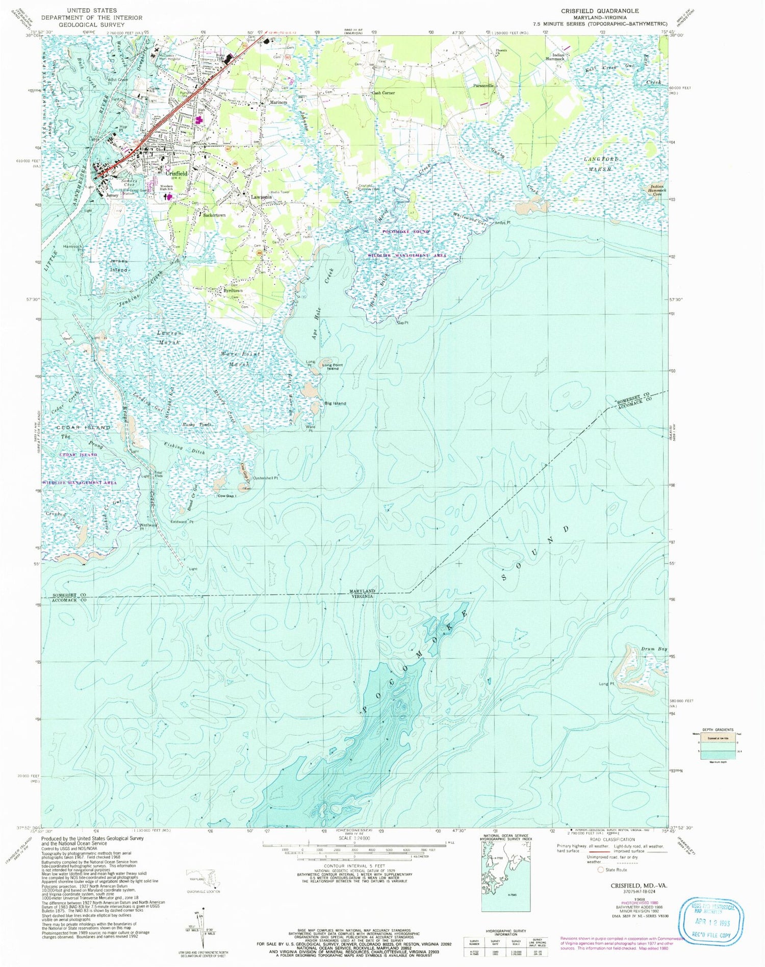
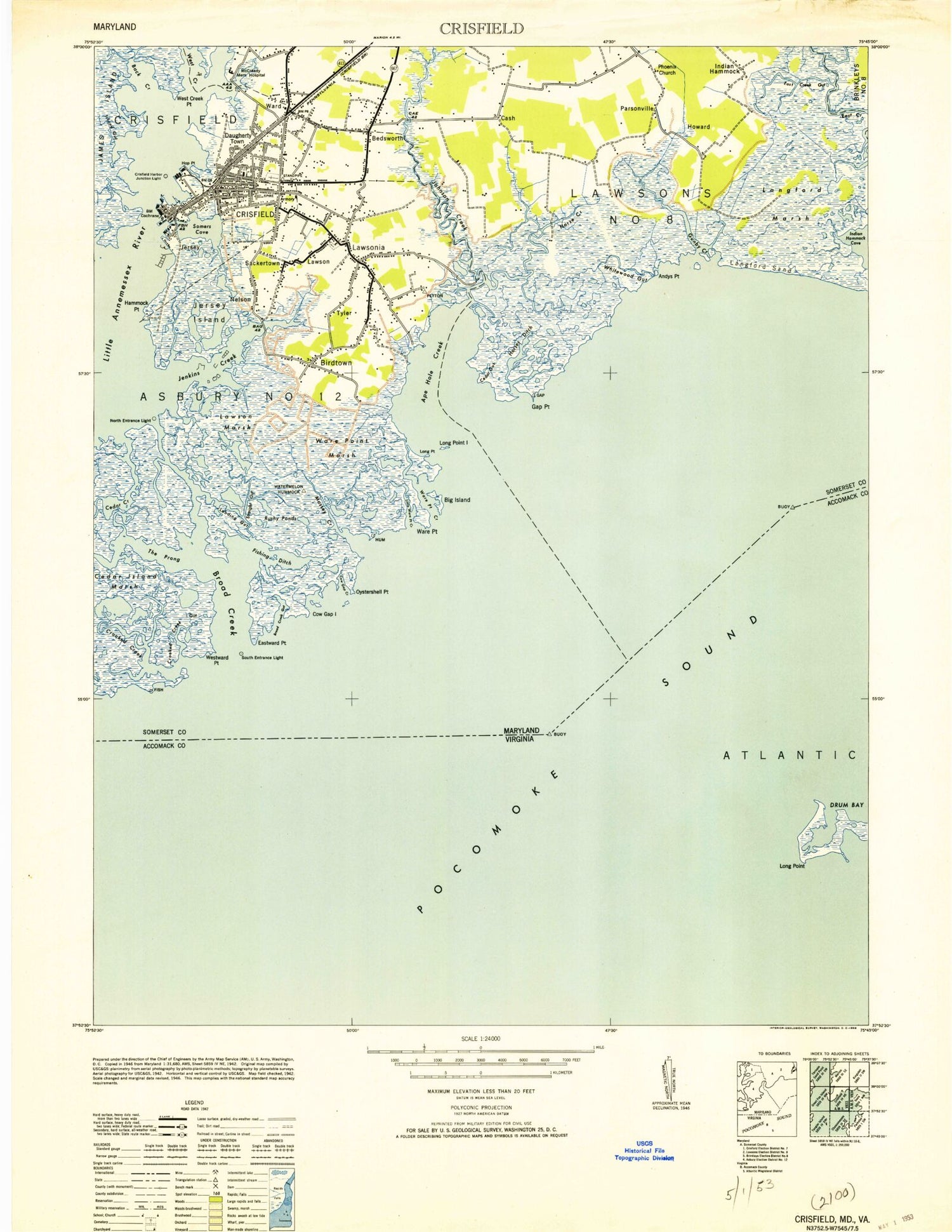
Classic USGS Crisfield Maryland 7.5'x7.5' Topo Map
Couldn't load pickup availability
Historical USGS topographic quad map of Crisfield in the states of Maryland, Virginia. Typical map scale is 1:24,000, but may vary for certain years, if available. Print size: 24" x 27"
This quadrangle is in the following counties: Accomack, Somerset.
The map contains contour lines, roads, rivers, towns, and lakes. Printed on high-quality waterproof paper with UV fade-resistant inks, and shipped rolled.
Contains the following named places: Andys Point, Ape Hole Creek, Back Creek, Big Island, Broad Creek, Broad Creek Gut, Cedar Creek, Cow Gap Creek, Cow Gap Island, Crisfield, Crooked Creek, Crooked Creek Gut, East Creek Gut, Eastward Point, Fishing Ditch, Gap Point, Gunby Creek, Hammock Point, Hop Point, Horse Creek, Horse Ditch, Island Gut, Jenkins Creek, Jersey Island, Johnson Creek, Landing Gut, Langford Marsh, Lawson Marsh, Little Ware Point Creek, Long Point, Long Point Island, Massey Creek, Oystershell Point, Peyton School, Phoenix Church, Rushy Ponds, Somers Cove, Straight Gut, The Prong, Ware Point, Ware Point Marsh, West Creek, West Creek Point, Westward Point, Whitewood Gut, Woodson High School, Brick Kiln Channel, Langford Sand, Byrdtown, Cash Corner, Indian Hammock, Jersey, Lawsonia, Mariners, Parsonville, Sackertown, Crisfield Country Club, Edward McCready Memorial Hospital, Asbury Methodist Cemetery, Asbury United Methodist Church, Cedar Gut, Church of God, Carter G Woodson Elementary School, Crisfield High School, Crisfield Historic District, Crisfield Post Office, Daugherty Town, Enon Baptist Church of Deliverance, First Baptist Church, Holiness Christian Church, Howard (historical), Immanuel United Methodist Church, Lawson, Lilyan Stratton Corbin Public Library, Mariners Methodist Cemetery, Mariners United Methodist Church, Mount Pleasant United Methodist Church, Nelson, New Union Asbury Methodist Episcopal Church, Pocomoke Sound Wildlife Management Area, Public School Number Three, Saint Paul African Methodist Episcopal Church, Shiloh Memorial Methodist Episcopal Church, Tyler, Ward, Woodson Middle School, WLSL-FM (Crisfield), District 12 Asbury, Crisfield Fire Department Station 2, Crisfield Christian Academy, Crisfield Police Department, City of Crisfield, Alice Byrd Tawes Nursing Home, Coast Guard Station Crisfield, Lower Somerset Ambulance and Rescue Squad Station 8, Long Point, Andys Point, Ape Hole Creek, Back Creek, Big Island, Broad Creek, Broad Creek Gut, Cedar Creek, Cow Gap Creek, Cow Gap Island, Crisfield, Crooked Creek, Crooked Creek Gut, East Creek Gut, Eastward Point, Fishing Ditch, Gap Point, Gunby Creek, Hammock Point, Hop Point, Horse Creek, Horse Ditch, Island Gut, Jenkins Creek, Jersey Island, Johnson Creek, Landing Gut, Langford Marsh, Lawson Marsh, Little Ware Point Creek, Long Point, Long Point Island, Massey Creek, Oystershell Point, Peyton School, Phoenix Church, Rushy Ponds, Somers Cove, Straight Gut, The Prong, Ware Point, Ware Point Marsh, West Creek, West Creek Point, Westward Point, Whitewood Gut, Woodson High School, Brick Kiln Channel, Langford Sand, Byrdtown, Cash Corner, Indian Hammock, Jersey, Lawsonia, Mariners, Parsonville, Sackertown, Crisfield Country Club, Edward McCready Memorial Hospital, Asbury Methodist Cemetery, Asbury United Methodist Church, Cedar Gut, Church of God, Carter G Woodson Elementary School, Crisfield High School, Crisfield Historic District, Crisfield Post Office, Daugherty Town, Enon Baptist Church of Deliverance, First Baptist Church, Holiness Christian Church, Howard (historical), Immanuel United Methodist Church, Lawson, Lilyan Stratton Corbin Public Library, Mariners Methodist Cemetery, Mariners United Methodist Church, Mount Pleasant United Methodist Church, Nelson, New Union Asbury Methodist Episcopal Church, Pocomoke Sound Wildlife Management Area, Public School Number Three, Saint Paul African Methodist Episcopal Church, Shiloh Memorial Methodist Episcopal Church, Tyler, Ward, Woodson Middle School, WLSL-FM (Crisfield), District 12 Asbury, Crisfield Fire Department Station 2, Crisfield Christian Academy, Crisfield Police Department, City of Crisfield, Alice Byrd Tawes Nursing Home, Coast Guard Station Crisfield, Lower Somerset Ambulance and Rescue Squad Station 8, Long Point