MyTopo
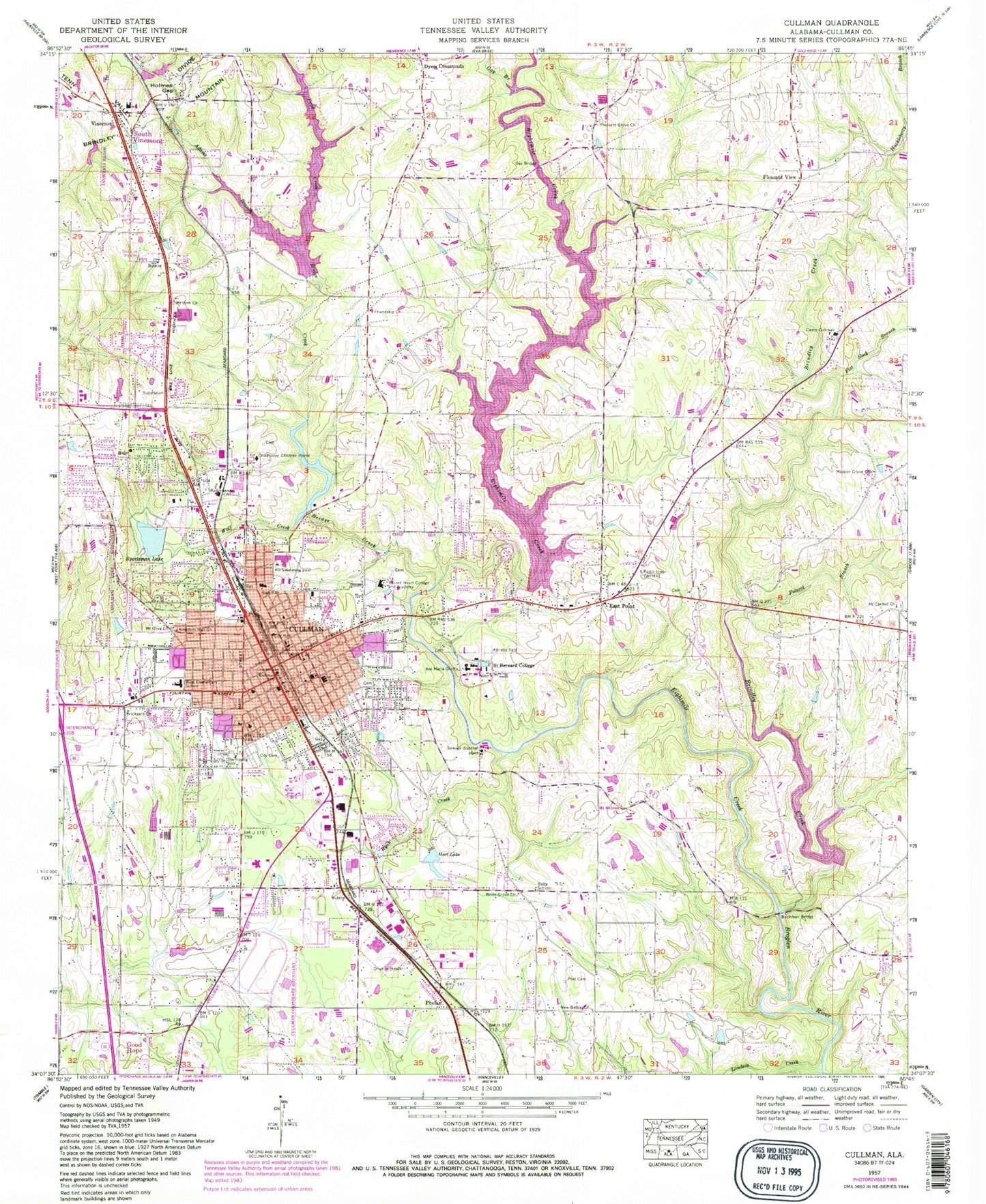
Classic USGS Cullman Alabama 7.5'x7.5' Topo Map
Couldn't load pickup availability
Historical USGS topographic quad map of Cullman in the state of Alabama. Typical map scale is 1:24,000, but may vary for certain years, if available. Print size: 24" x 27"
This quadrangle is in the following counties: Cullman.
The map contains contour lines, roads, rivers, towns, and lakes. Printed on high-quality waterproof paper with UV fade-resistant inks, and shipped rolled.
Contains the following named places: Adams Branch, Bolte Elementary School (historical), Bridge Creek, Brindley Creek, Buchman Bridge, Camp Cullman, Childhaven Children Home, Cullman, Dyers Crossroads, East Point, Eightmile Creek, Flat Rock Branch, Friendship Baptist Church, Gay Branch, Gay Bridge, Hart Lake, Holmes Gap, Huckleberry Branch, Kingdom Hall Church, Mission Grove Baptist Church, Mount Carmel Methodist Church, Mount Zion Methodist Church, Pfiel Cemetery, Phelan, Pleasant Grove Baptist Church, Pleasant View, Polecat Branch, Pope Creek, Ryan Creek, Saint Bernard College, Sportman Lake, Vinemont, West Elementary School, White Grove Missionary Baptist Church, Forest Ingram Lake, Forrest Ingram Dam, Lee Hart Dam, Lake Catoma Dam, Lake Catoma, Carl Budweg Dam, Davis Lake, Sportsman Lake Dam, Eva Road Lake, Eva Road Lake Dam, L B Hayes Dam, Hayes Lake, George Lake, Lake George Dam, Bolte, Christ Lutheran Church, Clark Street Church of God, Cullman First Baptist Church, Cullman High School, Cullman Middle School, Cullman Public School (historical), East Elementary School, East Point Cumberland Presbyterian Church, First Assembly of God Church, First Christian Church, First Church of the Nazarene, First Presbyterian Church, Grace Episcopal Church, Kelly School, Mount Hebron Baptist Church, North Alabama Horticulture Substation, Northside Baptist Church, Sacred Heart Catholic Church, Sacred Heart School, Saint Andrews United Methodist Church, Saint Johns United Church, Saint Pauls Lutheran School, Seventh Street Baptist Church, Smithdale, South Vinemont, Vinemont High School, Saint Pauls Lutheran Church, Cullman County Courthouse, Loveless Creek, Mount Olive Primitive Baptist Church, New Bethel Church of Christ, Sacred Heart College and Academy, Wolf Creek, Cullman Shopping Center, Town Square Shopping Center, Cullman Downtown Commercial Historic District, Cullman Historic District, WFMH-AM (Cullman), NEW-AM (Cullman), WXXR-AM (Cullman), WKLN-FM (Cullman), WFMH-FM (Cullman), Cullman County, Milner (historical), Cullman County Vocational Center, Cullman Division, Cullman Post Office, Vinemont Post Office, Mount Carmel Cemetery, Pleasant Grove Baptist Church Cemetery, East Point Cumberland Presbyterian Church Cemetery, Mount Zion Cemetery, Bethel Baptist Church, Carrol Acres, Carrol Acres Park, Catoma Baptist Church, Cullman County Fairgrounds, Cullman County Museum, Cullman Industrial Park, Cullman Regional Medical Center, East Point Elementary School (historical), East Side Park, Faith Baptist Church, King Edward Plaza Shopping Center, Main Avenue Park, Margaret Engle Park, Nesmith Park, Northwood, Northwood Park, Sacred Heart Cemetery, Terrace Heights, Terrace Heights Park, Woodland Medical Center, Cullman City Cemetery, Pleasant View Missionary Baptist Church, Saint Bernard Abbey Cemetery, City of Cullman, Town of South Vinemont, East Point Census Designated Place, Cullman Emergency Medical Services, Cullman Fire Rescue Station 1, Cullman Fire Rescue Station 2, Vinemont - Providence Volunteer Fire Department Station 2, Cullman County Sheriff's Office, Cullman Police Department, Town of Berlin