MyTopo
Classic USGS Curtis Bay Maryland 7.5'x7.5' Topo Map
Couldn't load pickup availability
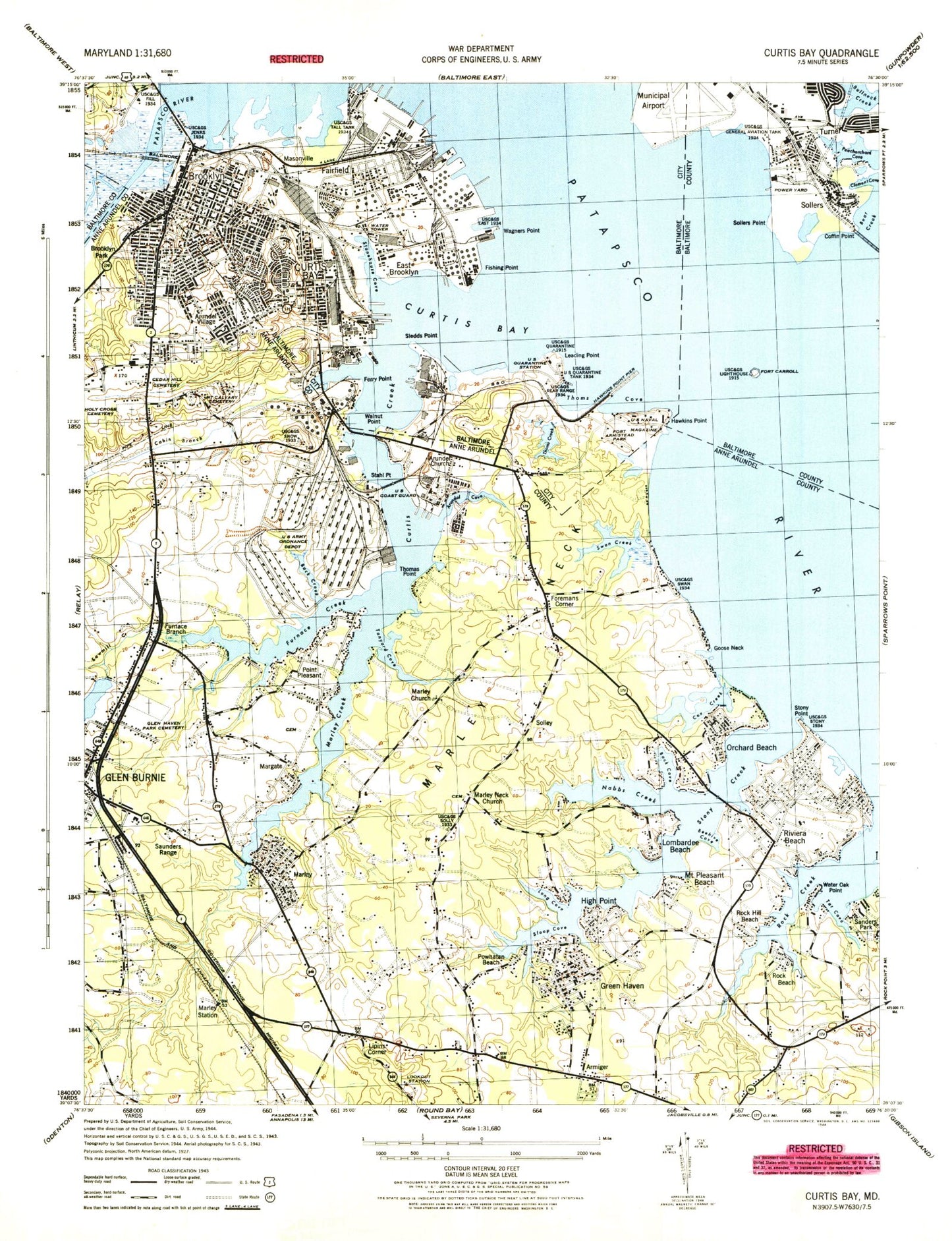
Historical USGS topographic quad map of Curtis Bay in the state of Maryland. Typical map scale is 1:24,000, but may vary for certain years, if available. Print size: 24" x 27"
This quadrangle is in the following counties: Anne Arundel, Baltimore, Baltimore (city).
The map contains contour lines, roads, rivers, towns, and lakes. Printed on high-quality waterproof paper with UV fade-resistant inks, and shipped rolled.
Contains the following named places: Arundel Cove, Arundel Village, Back Cove, Back Creek, Bear Creek, Beehive Cove, Belle Grove Elementary School, Big Burley Cove, Brooklyn Park Middle School, Park Elementary School, Cabin Branch, Calvary Baptist Church, Cedar Hill Cemetery, Clement Cove, Coffin Point, Goose Neck, Cox Creek, Dundalk Vocational School, Eli Cove, Faith Baptist Church, Faith Church, George Fox Middle School, Freetown Elementary School, Furnace Creek, Glen Burnie High School, Glen Church, Glen Haven Memorial Park, Glendale Elementary School, Grace Baptist Church, Green Haven Church, Hall United Methodist Church, Holy Cross Cemetery, Long Cove, Lovel Point, Marley Creek, Marley Middle School, Marley Neck, Marley Elementary School, Messiah United Methodist Church, Mount Calvary Cemetery, Nabbs Creek, North Glen Church, North Glen Elementary School, Northeast High School, Peachorchard Cove, Point Pleasant Elementary School, Riviera Beach Elementary School, Rock Creek, Sabbath Church, Saint Andrews Episcopal Church, Sawmill Creek, Sloop Cove, Sollers Point, Solleys Cemetery, Solleys Cove, Stahl Point, Stony Creek, Stony Point, Swan Creek, Tanyard Cove, Tar Cove, Thomas Point, Water Oak Point, Wateredge Baptist Church, John Wesley United Methodist Church, Whites Cove, Woodside Elementary School, Joy Harbor, Sollers Point, Fort McHenry Anchorage, Masonville, Fishing Point Shoal, Sollers Point Shoal, Marine Channel, Hawkins Point Shoal, Brewerton Angle, Coal Pier Channel, Saint James Frances School, New Shiloh Baptist Church, Armiger, Arundel Gardens, Bar Harbor, Brooklyn Park, Clear Water Beach, Cottage Grove Beach, Foremans Corner, Fort Carroll, Furnace Branch, Glen Burnie, Green Haven, Harundale, High Point, Lipins Corner, Margate, Marley, Mount Pleasant Beach, Old Glory Beach, Orchard Beach, Point Pleasant, Powhatan Beach, Riviera Beach, Rock Hill Beach, Rockview Beach, Sanders Park, Sharonville, Solley, Stony Beach, Sunset Beach, Turner, Woodcrest, Christ the King Roman Catholic Church, Gospel Tabernacle Church, Fleming Elementary School (historical), Fleming Park, Friends Baptist Church, Greater Saint John Baptist Church (historical), Peach Orchard Park, Saint Matthews United Methodist Church, Turner School (historical), Turners Park, Long Hill Lookout Tower, Tar Cove Heliport, North Arundel Hospital Heliport, Baltimore Washington Medical Center, Arundel Cove Methodist Church, Brooklyn, Crisp Memorial Presbyterian Church, Curtis Bay, Curtis Bay, Curtis Bay Channel, Curtis Bay Elementary / Middle School, Curtis Creek, East Brooklyn, Fairfield, Ferry Point, Fishing Point, Fort McHenry Channel, Hawkins Point, Leading Point, Mount Ararat Baptist Church, Cherry Hill Elementary / Middle School, Patapsco Elementary School, Maree G Farring Elementary / Middle School, Benjamin Franklin High School at Masonville Cove, Reed Bird Island, Saint Paul's Evangelical Lutheran Church, Saint Rose of Lima School, Sledds Point, Stonehouse Cove, Thomas Creek, Thoms Cove, Victory Elementary School, Wagners Point, Walnut Point, Baltimore Municipal Airport (historical), Francis Scott Key Bridge, WJRO-AM (Glen Burnie), WWIN-FM (Glen Burnie), Barrett Park, Bay - Brook Elementary / Middle School, Bay Brook Park, Brooklyn Branch Enoch Pratt Free Library, Brooklyn Manor, Cherry Hill Park, Dundalk Marine Terminal, Fort Armistead (historical), Fort Armistead Park, Hawkins Point Military Reservation (historical), Hawkins Point Pier, Masonville (historical), Raisins Wharf, Reed Bird Island Park, Sea Wall Junction, Stone House Cove Station (historical), Tysons Wharf, All Souls Episcopal Church, Bay Brook Recreation Center, Brooklyn Bible Chapel, Brooklyn Homes, Brooklyn Seventh Day Adventist Church, Brooklyn United Methodist Church, Brooklyn Church of God, Church of God, Church of God in Christ, Church of God of Prophecy, Curtis Bay Recreation Center, Curtis Bay United Methodist Church, Fairfield Homes, First Baptist Church of Brooklyn, First Baptist Church of Fairfield, Gospel Assembly Church, Immanuel of Brooklyn United Methodist Church, Independent Baptist Church, Patapsco Wastewater Treatment Plant, Saint Anthonys Chapel, Saint Athanasius Roman Catholic Church, Saint Johns Evangelical Lutheran Church, Saints Peter and Paul Ukrainian Catholic Church, Saint Rose of Lima Roman Catholic Church, Wesleyan Methodist Church, Aspen Park, Bar Harbor Manor, Beauty Beach, Blossom Hills, Brandon Shores, Brandon Woods Energy Business Center, Brewers Island, Brightwater Beach, Brightwater Beach Yacht Club, Brooklyn Park Elementary School, Carvel Beach, Chesterfield, Chesterfield Gardens, Chesterfield Plaza, Chestnut Hill Cove, Community Gospel Church of Pasadena, Community United Methodist Church, Creek View, Elizabeths Landing, Emmanuel Lutheran Church, Free Town School (historical), Greenland Beach, Hall United Methodist Church Cemetery, Harundale Mall Shopping Center, Harundale Presbyterian Church, Havenwood Park, High Point Elementary School, Highpoint Park, Hillcrest, Hillside Park, Independent Gospel Church, Jenkins Memorial Church, Klasmeier Point, Korean Seventh Day Adventist Church, Lake Riviera, Lake View