MyTopo
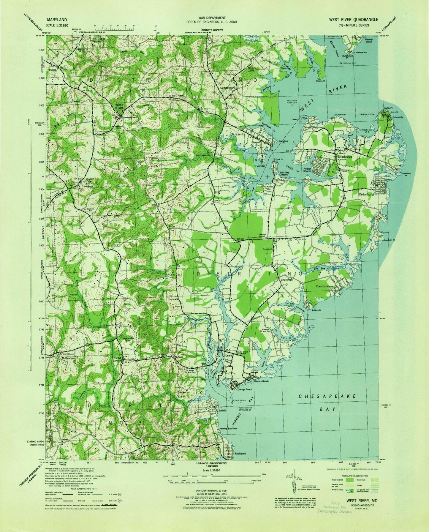
Classic USGS Deale Maryland 7.5'x7.5' Topo Map
Couldn't load pickup availability
Historical USGS topographic quad map of Deale in the state of Maryland. Map scale may vary for some years, but is generally around 1:24,000. Print size is approximately 24" x 27"
This quadrangle is in the following counties: Anne Arundel, Calvert.
The map contains contour lines, roads, rivers, towns, and lakes. Printed on high-quality waterproof paper with UV fade-resistant inks, and shipped rolled.
Contains the following named places: All Hardwoods Branch, Almar Estates, Anne Arundel County Fire Department Harwood - Lothian Station 9, Avalon Shores, Avalon Shores Volunteer Fire Department Station 41, Back Bay, Back Bay Beach, Back Creek, Bahama View, Bare Neck Shore, Battees Point, Bay Country, Baywalker Village, Baywood Farms, Beech Hollow, Big Woods Branch, Bountys View, Broadwater, Broadwater Creek, Broadwater Point, Camp Jalal, Camp Kahler, Camp Wabanna, Cape Anne, Carrie Weedon Elementary School, Carrs Creek, Castle Acres, Cedar Grove United Methodist Church, Cedar Point, Cedarhurst, Cedarlea, Chalk Point, Chapel Knoll, Cherry Point, Chesapeake Christian School, Chesapeake Yacht Club, Cheston Creek, Cheston Creek Marshes, Cheston Marsh, Cheston Point, Cheston Point Marsh, Chews Memorial United Methodist Church, Chews Memorial United Methodist Church Cemetery, Christ Episcopal Church, Church of Saint John the Evangelist, Church Run, Churchton, Churchton Post Office, Churchton Recreation Area, Columbia Beach, Councillors Point, Cox Creek, Cumberstone, Deadwood Cove, Deale, Deale Airport, Deale Beach, Deale Census Designated Place, Deale Elementary School, Deale Mission, Deale Post Office, Deale Volunteer Fire Department Station 42, Deale-Tracys Park, Deep Cove Creek, Deep Creek, Deep Creek Airpark, Development Run, District 7, District 8, Dog House Run, Drum Point, Dry Valley, Dutchman Point, Ebenezer Church, Elbow Lake, Fairhaven-on-the-Bay, Fairview, Flag Pond, Flag Pond Creek, Forbidden Run, Forest Point, Fossil Ravine, Franklin Cemetery, Franklin Manor Beach, Franklin Manor-on-the-Bay, Franklin Memorial United Methodist Church, Fresh Pond, Gales Creek, Galesville, Galesville Census Designated Place, Galesville Estates, Galesville Post Office, Galesville Volunteer Fire Department Station 1, Gross Creek, Gully Run, Hartges Boatyard, Hartges Wharf, Harwood, Harwood Hollow, Harwood Post Office, Herring Bay, Herring Bay View, Hidden Pond, Hidden Pond Branch, Highview-on-the-Bay, Holly Landing, Honeysuckle Hollow, Hopkins Cove, Hornbeam Hollow, Horseshoe Bog, Huckleberry Woods, Hunter Hollow, Inspecting Creek, Jack Creek Marsh, Jewell, Johns Creek, Leitch, Lerch Creek, Lerch Creek Marsh, Locust Branch, Lofty Heights, Long Bar, Long Marsh, Long Point, Lothian, Lothian Elementary School, Masons Beach, McKendree, McKinley Point, Meadow Pond, Mimosa Cove, Mount Zion, Neiman Point, Normans Creek, Normans Creek Marsh, North Deale, Nutwell, Nutwell School, Oakland, Owings Beach, Parish Creek, Parker Creek, Parker Island, Paulownia Branch, Pennbrooke, Period Pond, Pistol Run, Pony Branch, Popham Creek, Popham Creek Marsh, Powerline Branch, Pumphandle Branch, Rest Haven, Rhode River, Rockhold Creek, Saint James Episcopal Church, Saint Josephs School, Saint Mark's Chapel of Saint James' Parish Cemetery, Saint Marks Episcopal Church, Salt Pond, Sand Point, Sand Point Marsh, Sapling Branch, Scaffold Creek, Scaffold Creek Marsh, Scaffold Point, Scaffold Point Marsh, School Creek, Scott School, Scottown Marsh, Selassie Villa, Shady Oaks, Shady Oaks Marina, Shady Oaks Marsh, Shady Side, Shady Side Census Designated Place, Shady Side Elementary School, Shady Side Marina, Shady Side Post Office, Shadyside Airfield, Shadyside Recreation Area, Slash Run, Smith Creek, Smith Creek Marsh, Snug Harbor Marsh, Snug Harbor Park, South County Branch Library, South Creek, South Creek View, Southern High School, Southern Middle School, Spyglass, Steiners Wharf, Sudley, Sudleys Choice, Sunshine One Marina, Swans, Tabernacle, Tall Oaks, Tenthouse Creek, The Hills, The Swamp, Tiffany Woods, Town Point, Town Point Marina, Traceys Elementary School, Traceys Elementary School at Southern Middle School, Traceys Landing, Traceys Meadows, Tracys Creek, Tracys Landing, Tracys Landing Post Office, Tracys Landing School, Trotts Branch, Vanishing Run, Variable Marsh, Warners Point, Warthen Knolls, Webbs Corner, West Creek Marsh, West River, West River Plantation, West River Post Office, West Shadyside, Westelee, Whitestake Point, Willow Run, Wuthering Heights, ZIP Codes: 20733, 20751, 20764, 20765, 20776, 20778, 20779