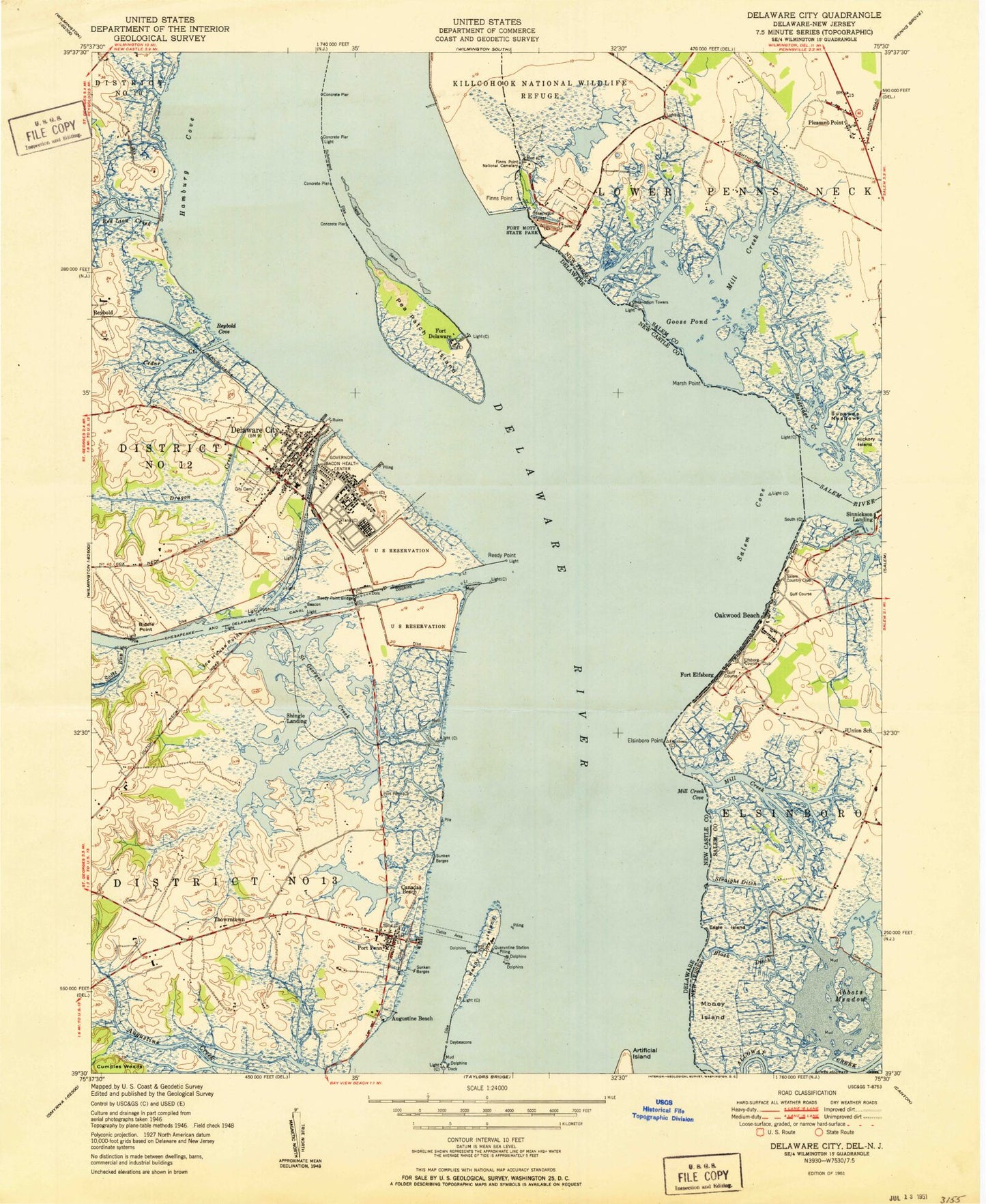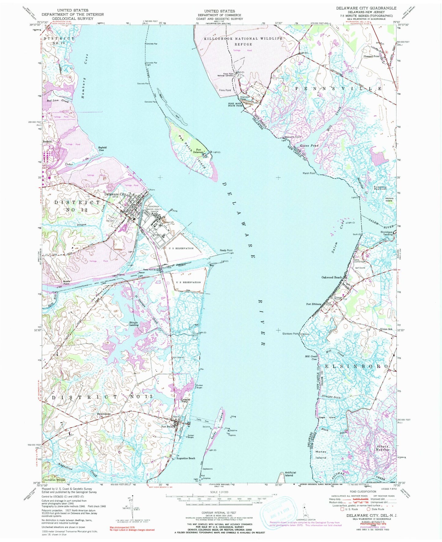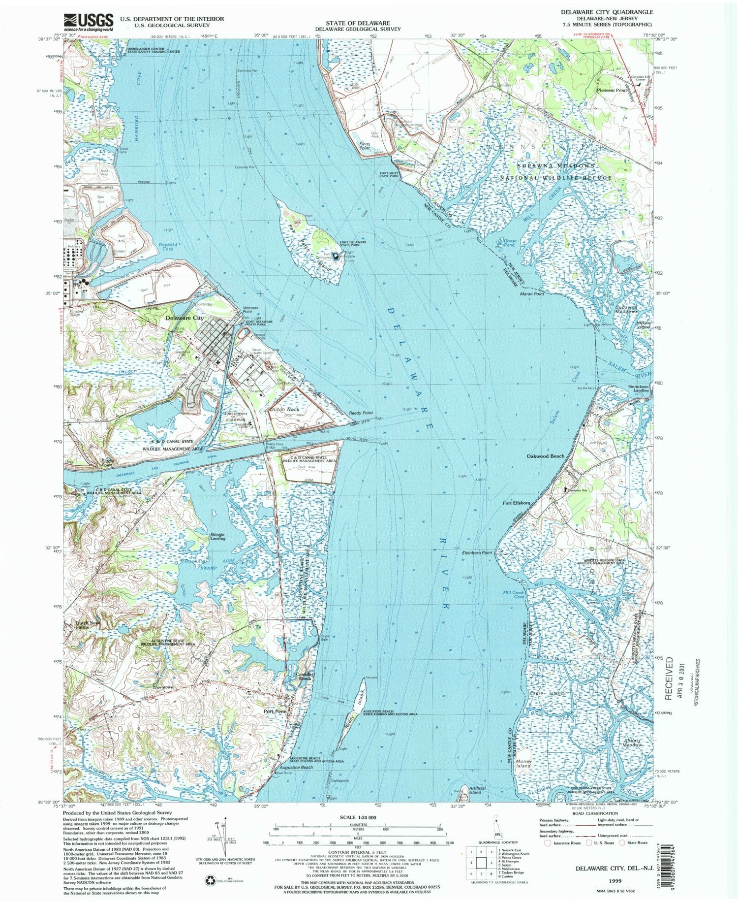
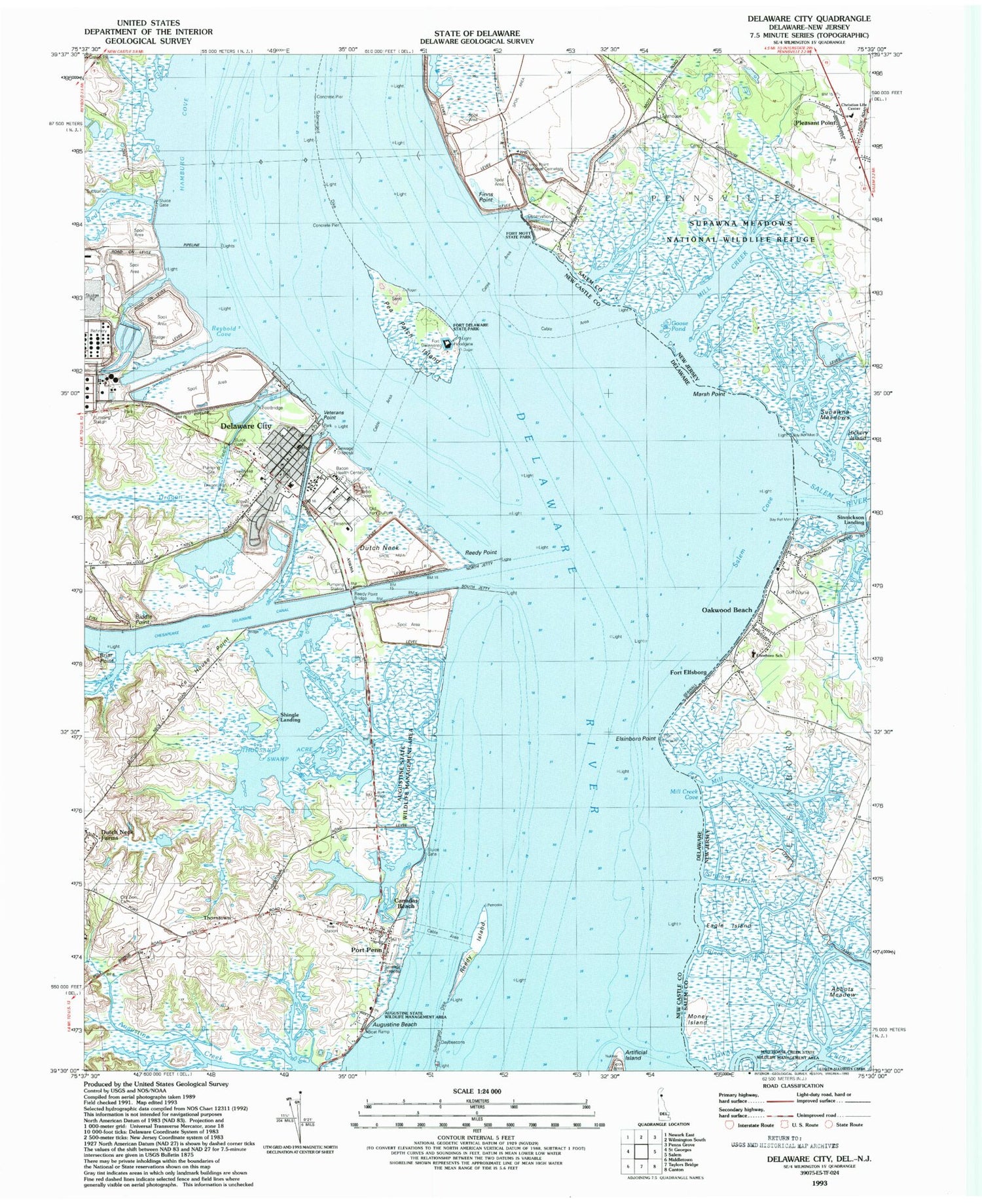

MyTopo
Classic USGS Delaware City Delaware 7.5'x7.5' Topo Map
Couldn't load pickup availability
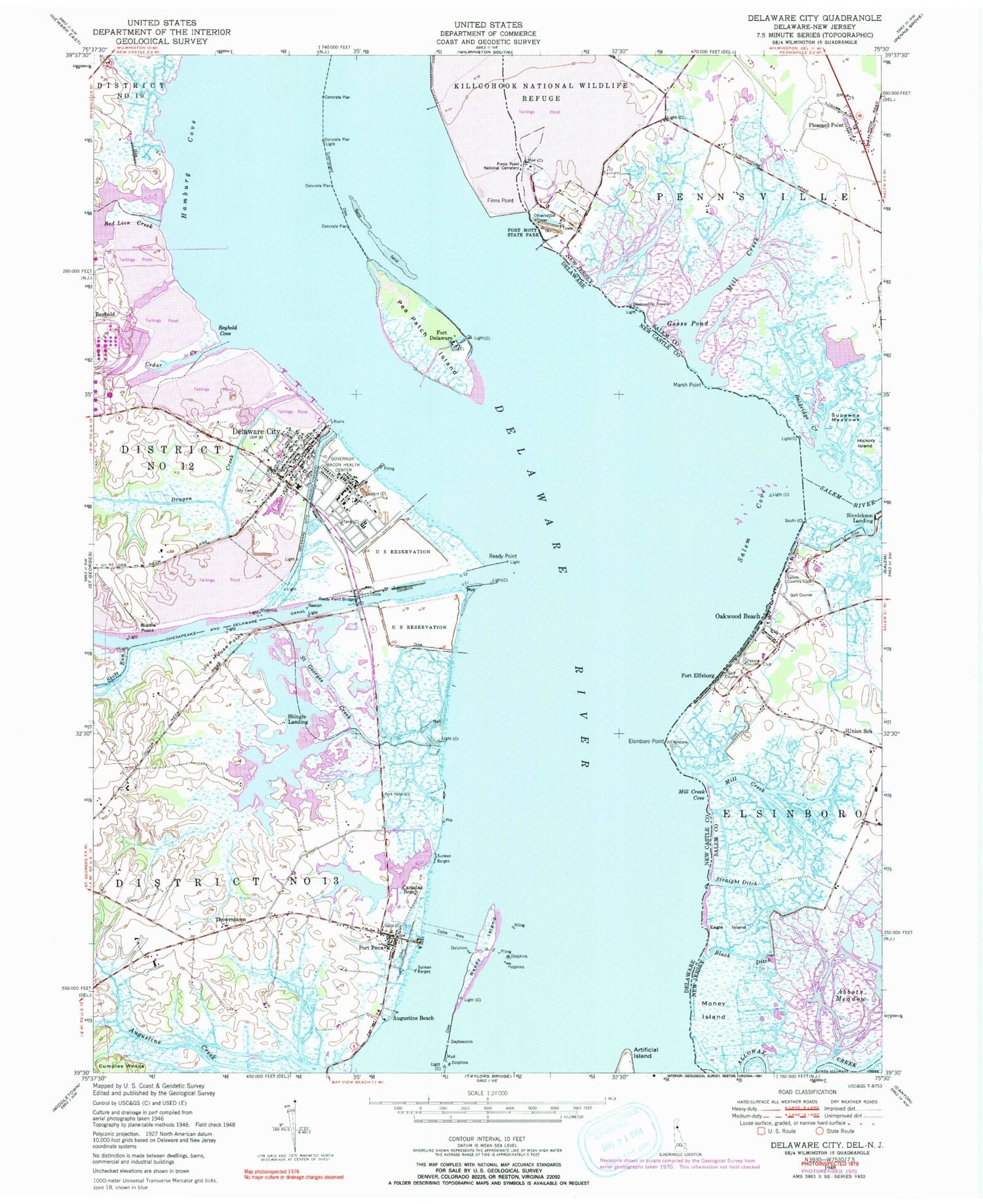
Historical USGS topographic quad map of Delaware City in the states of Delaware, New Jersey. Map scale may vary for some years, but is generally around 1:24,000. Print size is approximately 24" x 27"
This quadrangle is in the following counties: New Castle, Salem.
The map contains contour lines, roads, rivers, towns, and lakes. Printed on high-quality waterproof paper with UV fade-resistant inks, and shipped rolled.
Contains the following named places: Ackan Manangaha, Alloway Creek, Ashton House, Augustine Beach, Augustine Wildlife Area, Back Ditch, Baldridge Creek, Battery Alburtis, Battery Allen, Battery Arnold, Battery Clermont Best, Battery Dodd, Battery Edwards, Battery Gibson, Battery Gregg, Battery Harker, Battery Hentig, Battery Krayenbuhl, Battery Read, Battery Rodney, Battery Torbert, Biddle Point, Black Ditch, Black Ditch Bar, Branch Channel Bridge, Bulkhead Bar Range, Bulkhead Shoal, Canadas Beach, Cedar Creek, Christ Church, Christian Life Center, Circle R Airport, City of Delaware City, Cumples Woods, Delaware City, Delaware City Branch Channel, Delaware City Elementary School, Delaware City Fire Company Station 15, Delaware City Hall, Delaware City Library, Delaware City Police Department, Delaware City Post Office, Delaware City Presbyterian Church, Dilworth House, Dragon Creek, Dragon Run Park, Eagle Island, Ebenezer United Methodist Church, Elfsborg Country Club, Elsinboro Elementary School, Elsinboro Fire Company, Elsinboro Point, Finns Point, Finn's Point National Cemetery, First Presbyterian Church, Fort Delaware, Fort Delaware State Park, Fort Dupont, Fort Elfsborg, Fort Mott, Fort Mott State Park, Goose Island Flats, Goose Pond, Governor Bacon Health Center, Green Hill Cemetery, Hamburg Cove, Hazel Glen, Hickory Island, Higgins House, Ice Harbor, Ice House Point, Killcohook National Wildlife Refuge, Marldale, Marsh Point, Mill Creek, Mill Creek Cove, Money Island, Mount Salem Union American Methodist Episcopal Church, Mount Salem United African Methodist Episcopal Church, New Castle Range, Oakwood Beach, Pea Patch Island, Pea Patch Shoal, Penns Neck, Pleasant Point, Port Penn, Port Penn Census Designated Place, Port Penn Post Office, Port Penn Volunteer Fire Company, Red Lion Creek, Red Lion Division, Reedy Island, Reedy Island Bar, Reedy Island Range, Reedy Point, Reedy Point Bridge, Reybold Cove, Saint Georges Creek, Saint Pauls Catholic Church, Salem Country Club, Salem Cove, Salem River, Scott Run, Shingle Landing, Straight Ditch, Supawna Meadows, Supawna Meadows National Wildlife Refuge, Tailings Pond, Thorntown, Thousand Acre Swamp, Tom Creek, Union School, ZIP Codes: 08070, 19706, 19731