MyTopo
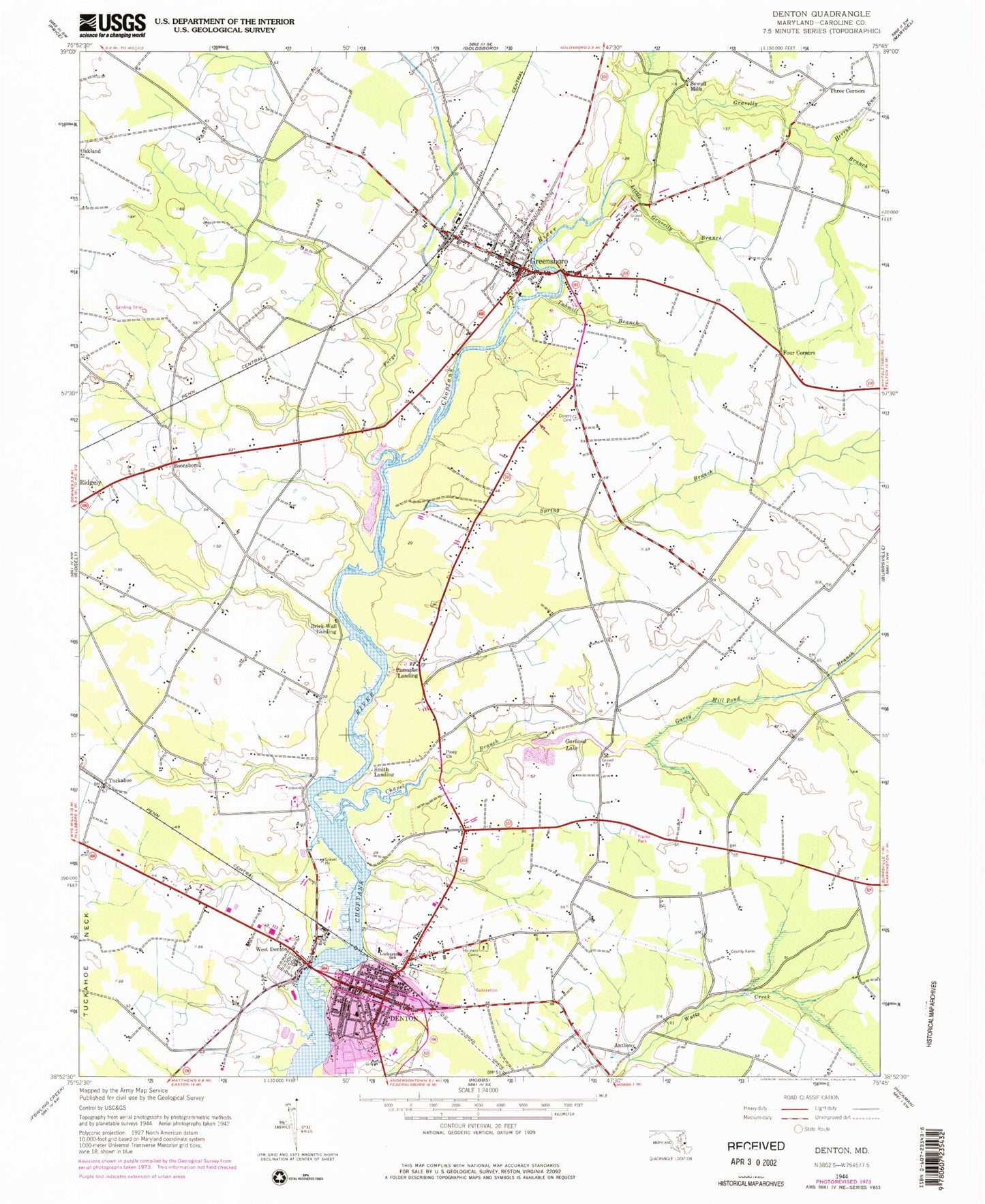
Classic USGS Denton Maryland 7.5'x7.5' Topo Map
Couldn't load pickup availability
Historical USGS topographic quad map of Denton in the state of Maryland. Map scale may vary for some years, but is generally around 1:24,000. Print size is approximately 24" x 27"
This quadrangle is in the following counties: Caroline.
The map contains contour lines, roads, rivers, towns, and lakes. Printed on high-quality waterproof paper with UV fade-resistant inks, and shipped rolled.
Contains the following named places: Adams Landing, Anthony, Bethel African Methodist Episcopal Church, Boonsboro, Brick Wall Landing, Bullocks Plaza Shopping Center, Calvert Acres, Caroline County Courthouse, Caroline County Detention Center, Caroline County Farm, Caroline County Sheriff's Office, Caroline County Vocational Center, Caroline Nursing Home, Caroline Public Library, Chapel Branch, Chapel Bridge, Choptank Overlook, Choptank Ponds, Daniel Crouse Memorial Park, Denton, Denton Bridge, Denton Cemetery, Denton Church of the Brethren, Denton Community Park, Denton Ferry, Denton Historic District, Denton Police Department, Denton Post Office, Denton Town Hall, Denton Volunteer Fire Company Station 300, District 2 Greensboro, Drivers Crossroads, First Wesleyan Church, Forge Branch, Four Corners, Foxgrape Farm, Garey Mill Pond Branch, Gareys, Garland Lake, Greensboro, Greensboro Baptist Church, Greensboro Carnival Ground, Greensboro Cemetery, Greensboro Christian Park, Greensboro City Hall, Greensboro Elementary School, Greensboro Lions Club Community Park, Greensboro Police Department, Greensboro Post Office, Greensboro Volunteer Fire Company Station 600, Holiness Camp, Holly Corner, Holly Hill Estates, Holy Cross Cemetery, Homestead Manor Assisted Living Center, Kings Apostolic Holiness Church, Lions Park, Little Gravelly Branch, Lockerman Middle School, Lor-J Estates, Maple Village, Moores Chapel, Moot Point Farm, Mount Pleasant Methodist Church, North Caroline High School, Oakland Acres, Oasis, Ober Park, Oil City, Old Saint Lukes Cemetery, Olive Branch Lodge Park, Passapae Landing, Pelot Bird Sanctuary, Pigg Point, Pilgrim Holiness Church, Piney Church, Ridgely Acres, Ridgely Airpark, Riding Acres, Riverview Gardens, Saint Elizabeths Cemetery, Saint Lukes Methodist Church, Saint Pauls Methodist Episcopal Church, Saulsbury Creek, School Number 10, School Number 2, School Number 3, School Number 4, School Number 8, Sewell Mills, Smith Landing, Spiering Airport, Spring Branch, Spring Grove Cemetery, The Gables at Caroline Assisted Living Center, Tower Mobile Home Park, Town of Denton, Town of Greensboro, Townsends Cross Roads, Tubmill Branch, Wesleyan Christian Elementary School, Wesleyan Health Care Center, West Denton, West Denton Census Designated Place, WKDI-AM (Denton), ZIP Code: 21639