MyTopo
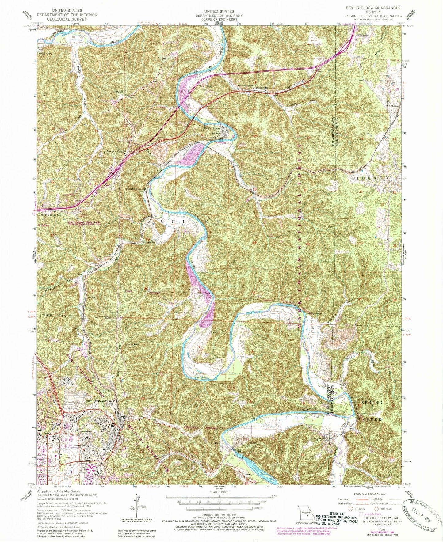
Classic USGS Devils Elbow Missouri 7.5'x7.5' Topo Map
Couldn't load pickup availability
Historical USGS topographic quad map of Devils Elbow in the state of Missouri. Typical map scale is 1:24,000, but may vary for certain years, if available. Print size: 24" x 27"
This quadrangle is in the following counties: Phelps, Pulaski.
The map contains contour lines, roads, rivers, towns, and lakes. Printed on high-quality waterproof paper with UV fade-resistant inks, and shipped rolled.
Contains the following named places: Calvary Church, Deckers Point, Deckers Ridge, Devils Elbow, Dry Creek, Dry Creek Cemetery, Hale Cemetery, Hooker, Hooker Hollow, Hooker School, Hunt Siding, Lee Siding, Lost Hill, Moab, Morgan Heights, Mossy Spring, Ousley Spring, Rockwell Cemetery, Round Pond Hollow, Shanghai Spring, Shultz Ford, Smoky Hollow, Spaulding Cemetery, Spring Creek, Spring Creek, Spring Creek Bluff, Spring Creek Cemetery, Strawstack Hollow, Ware Hollow, Weeks Hollow, Wern Siding, Spring Creek School, Low Gap School (historical), Fort Leonard Wood State Wildlife Management Area, Mossy Resort (historical), Possum Lodge, Stewart Camp (historical), Anderson School (historical), Munger Resort (historical), Hiawatha Lodge (historical), Cedar Lodge (historical), Grahams Resort (historical), Rigsby Cottages (historical), Meadow Brook Lodge, Maze School (historical), Ormsby Place, Dry Creek School (historical), Dry Creek Church (historical), Thompson Cemetery, Mayfield Cemetery, Fort Wood Lookout Tower, Decker (historical), Waynesville Rural Fire Protection District Station 3, Fort Leonard Wood Fire and Emergency Services Headquarters, Riverside (historical), General Leonard Wood Army Community Hospital, Crawford Ousley Cemetery, Ousley Cemetery, Boulware Cemetery, Devils Elbow Post Office, Fort Leonard Wood Post Office, Calvary Church, Deckers Point, Deckers Ridge, Devils Elbow, Dry Creek, Dry Creek Cemetery, Hale Cemetery, Hooker, Hooker Hollow, Hooker School, Hunt Siding, Lee Siding, Lost Hill, Moab, Morgan Heights, Mossy Spring, Ousley Spring, Rockwell Cemetery, Round Pond Hollow, Shanghai Spring, Shultz Ford, Smoky Hollow, Spaulding Cemetery, Spring Creek, Spring Creek, Spring Creek Bluff, Spring Creek Cemetery, Strawstack Hollow, Ware Hollow, Weeks Hollow, Wern Siding, Spring Creek School, Low Gap School (historical), Fort Leonard Wood State Wildlife Management Area, Mossy Resort (historical), Possum Lodge, Stewart Camp (historical), Anderson School (historical), Munger Resort (historical), Hiawatha Lodge (historical), Cedar Lodge (historical), Grahams Resort (historical), Rigsby Cottages (historical), Meadow Brook Lodge, Maze School (historical), Ormsby Place, Dry Creek School (historical), Dry Creek Church (historical), Thompson Cemetery, Mayfield Cemetery, Fort Wood Lookout Tower, Decker (historical), Waynesville Rural Fire Protection District Station 3, Fort Leonard Wood Fire and Emergency Services Headquarters, Riverside (historical), General Leonard Wood Army Community Hospital, Crawford Ousley Cemetery, Ousley Cemetery, Boulware Cemetery, Devils Elbow Post Office, Fort Leonard Wood Post Office