MyTopo
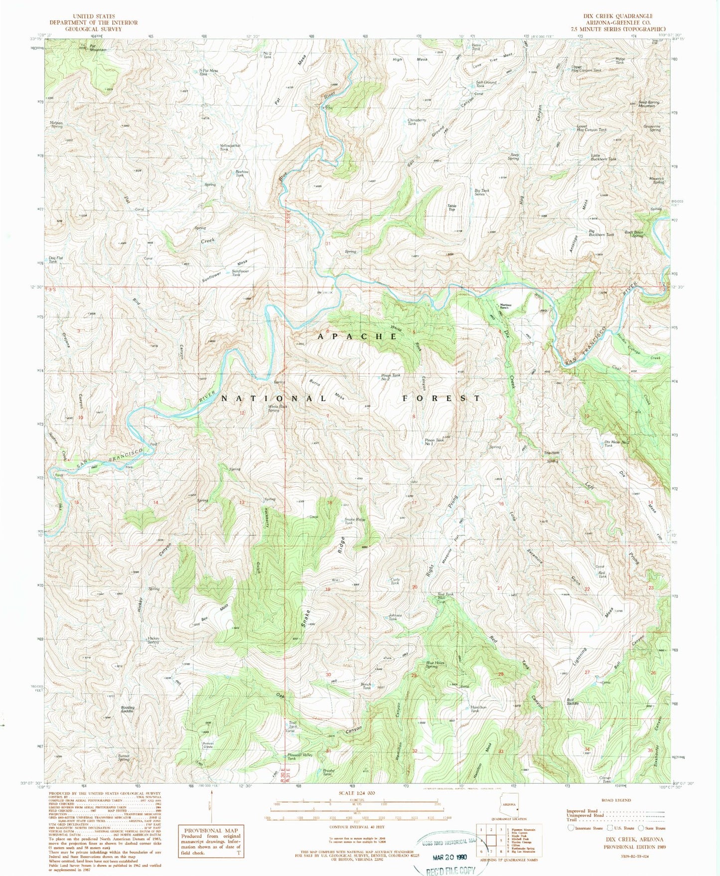
Classic USGS Dix Creek Arizona 7.5'x7.5' Topo Map
Couldn't load pickup availability
Historical USGS topographic quad map of Dix Creek in the state of Arizona. Map scale may vary for some years, but is generally around 1:24,000. Print size is approximately 24" x 27"
This quadrangle is in the following counties: Greenlee.
The map contains contour lines, roads, rivers, towns, and lakes. Printed on high-quality waterproof paper with UV fade-resistant inks, and shipped rolled.
Contains the following named places: Antelope Mesa, Basin Tank, Bee Mesa, Beehive Tank, Bench Tank, Big Buckhorn Tank, Big Tank Series, Big Tank Series Number One, Bird Canyon, Bloody Canyon Tank, Blow Out Spring, Blue Holes Spring, Blue River, Bobby Tank, Bootleg Saddle, Boulder Tank, Brushy Tank, Brushy Tanks Number One, Bull Canyon, Bull Canyon Tank, Bull Saddle, Burro Mesa, Burro Mesa Tank, Canyon Corral, Chinaberry Tank, Chuck Box Tank, Coal Creek, Corner Tank, Cottonwood Spring, Curly Tank, Dave Spring, Dix Creek, Dix Creek Corral, Dix Mesa Number One Tank, Dix Mesa Number Two Tank, Dix Mesa Tank, Draw Tank, Fence Tank, Frisco Bluff Spring, Grapevine Spring, Greenlee County, Hackberry Gulch, Hackberry Spring, Hamilton Canyon, Hamilton Mesa Corral, Hamilton Tank, Harden Cienega Creek, Hickey Canyon, Hickey Spring, High Mesa, High Mesa Tank, Hog Canyon, Hog Canyon Spring, Johnnie Tank, Layout Mesa, Left Prong Dix Creek, Lightening Mesa Corral, Lightening Mesa Tank, Lightning Mesa, Lightning Mesa Tank, Lone Sycamore Gulch, Lone Tree Mesa, Lower Buckhorn Tank, Lower Bull Tank, Lower Hog Canyon Tank, Malpais Spring, Martinez Ranch, Maverick Spring, Mesa Corral, Mesquite Flat, Mesquite Flat Tank, Mesquite Tank, Middle Tank, N Pat Corral, Narrow Spring, North Pat Mesa Tank, Number Two Tank, Oak Canyon, Oak Spring, Orejana Canyon, Panther Tank, Pat Corral, Pat Creek, Pat Mesa, Pat Mesa Tank, Pat Mountain, Pinon Tank Number One, Pleasant Valley, Pleasant Valley Tank, Pleasant Valley Tank Number Two, Point Spring, Red Flats Tank, Red Tank Canyon, Red Tank Corral, Red Tank Well, Ridge Tank, Right Prong Dix Creek, Rock Basin Spring, Ru Ranch, Salt Ground Canyon, Salt Ground Corral, Salt Ground Tank, Saltground Tank, Sardine Creek, Seep Spring, Seep Spring Mountain, Shake Spring, Snake Ridge, Snake Ridge Tank, Split Ridge Tank, Sunflower Corral, Sunflower Mesa, Sunflower Mesa Tank, Sunflower Tank, Sunset Glade, Sunset Spring, Table Top, The Hole, Trail Spring, Trail Tank, Upper Hog Canyon Tank, White Rock Canyon, White Rock Spring, Yellow Jacket Spring, Yellowjacket Tank, Yolk Spring, Zumwalt Corner Tank