MyTopo
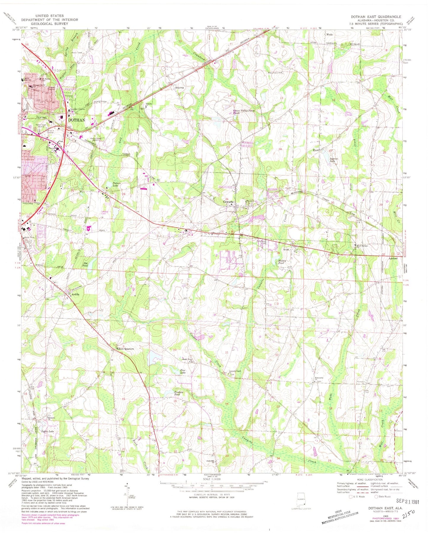
Classic USGS Dothan East Alabama 7.5'x7.5' Topo Map
Couldn't load pickup availability
Historical USGS topographic quad map of Dothan East in the state of Alabama. Map scale may vary for some years, but is generally around 1:24,000. Print size is approximately 24" x 27"
This quadrangle is in the following counties: Houston.
The map contains contour lines, roads, rivers, towns, and lakes. Printed on high-quality waterproof paper with UV fade-resistant inks, and shipped rolled.
Contains the following named places: Abundant Life Assembly of God Church, Ardilla, Ardilla School, Avon, Bethel Baptist Church, Beverlye Middle School, Blakey Pond, Bluff Springs Baptist Church, Bluff Springs Cemetery, Caroline Wilson Dam, Carver High School, Center School, Cher-O-Creek State Designated Tribal Statistical Area, City of Dothan Sanitary Landfill, Columbia Baptist Association Christian Ministry Center, Cooper Creek, Cowarts, Cowarts Baptist Church, Cowarts Cemetery, Cowarts Creek Cemetery, Cowarts Creek Freewill Baptist Church, Cowarts Post Office, Cowarts Town Hall, Cowarts Volunteer Fire Department, Creels Pond, Crestlawn Cemetery, Crippled Children Clinic, Dothan Church of God, Dothan Fire Department Station 5, Dye Pond, Dykes Lake, East Gate Estates, Emmanuel Mission Baptist Church, Encompass Health Rehabilitation Hospital of Dothan, Enon, Enon Church, Enterprise Church, Faith Baptist Church, Faith Deliverance Evangelical Church, Farm Center, First Freewill Baptist Church, First Pentecostal Church, Forest Park, Fowlers Pond, Frith Hill Church, Green Valley Farm Ponds, Houston County, Houston County Farm Center, Hurts Chapel Cemetery, Ingram Lake, Ingram Lake Dam, Jessie Forrester Dam, Jessie Forrester Lake, Kilgore's Roundabout Plantation Golf Course, Kingdom Hall of Jehovahs Witnesses, Liberty Baptist Church, Live Oaks Manor Retirement Home, Memphis Baptist Church, Memphis Cemetery, Metropolitan Church of God, Moodys Pond, Mount Pleasant Cemetery, Mount Pleasant Church, New Bethel Missionary Baptist Church, Noland Hospital Dothan, North Cowarts, Old Webb Road Baptist Church, Palms Mobile Home Park, Pecan Park Mobile Home Park, Pine Lake, Piney Grove Church, Pleasant Grove Church, Porters Lake, Saint Marys School, Saint Matthew Church, Sam Houston Industrial Park, Seventh Day Adventist Church of Dothan, Seventh Day Adventist Elementary School, Seventh United Holiness Church, Shady Grove Church, Smyrna, Smyrna Baptist Church, Southeast Alabama Medical Center Airport, Southeast Health Medical Center, Southside Acres, SpectraCare Health Systems Houston County Clinic, Stringer Street African Methodist Episcopal Church, Stringer Street Elementary School, The Christian Lighthouse Church, Town of Avon, Town of Cowarts, Trinity Missionary Baptist Church, WDHN-TV (Dothan), Weslyan Independent Methodist Church, Wet Weather Pond, Wildwood Mobile Home Park, Wilson Quarters, Wilsons Lake, Wiregrass Comprehensive Mental Health Center, WOOF-AM (Dothan), WOOF-FM (Dothan), WWNT-AM (Dothan), ZIP Code: 36321